Fare zones & calculating how much you pay Fare zones & calculating how much you pay
Auckland is divided into fourteen "fare zones". All travel is calculated based on how many zones you travel through, rather than how many trips you take.
Fares are based on the number of zones you travel through.
This means you can transfer between AT buses, trains and ferries and pay just one fare for your entire journey with your AT HOP card.
Make as many transfers as you like between buses, trains and ferries. Just make sure you tag on within 30 minutes of tagging off your previous service and complete this journey within four hours.
If you are travelling within a zone overlap area as part of a journey and paying with an AT HOP card (this means tagging on and off within the same overlap area) this may count as travelling through a new zone.
Find bus and train fares and ferry fares, or check the journey planner to work our your correct fare.
Ferry monthly passes
If you purchased a ferry monthly pass from 26 March 2020, you’re able to take advantage of the fully integrated fare system.
Customers who purchased a monthly ferry pass before 26 March 2020 will still be able to use their pass on ferries until the normal expiry date but won’t qualify or have access to the new fare inclusive connecting services until the ferry pass expires.
Example journey
Joe travels by bus and train across two zones from Otara to Greenlane. With his AT HOP card Joe's adult fare will be $4.20. If Joe paid with cash his total fare would be $10.00. A $4.00 one zone fare for the bus plus a $6.00 two zone fare for the train.
Sally travels by bus, ferry and train across two zones from Devonport to Newmarket. With her AT HOP card, Sally’s adult fare will be $5.80. If Sally paid with cash, her total fare would be $16.00. A $4.00 one zone bus fare, a $8.00 ferry fare plus $4.00 for one zone train fare. See other examples of journeys to see how fares are calculated.
Fare zones
The fourteen fare zones are:
- Warkworth, Hibiscus Coast, Upper North Shore and Lower North Shore in North Auckland,
- Helensville, Huapai and Waitakere in West Auckland,
- City, Isthmus and Waiheke in Central Auckland,
- Beachlands in East Auckland,
- Manukau North, Manukau South and Franklin in South Auckland.
Find out about where the zone boundaries are and where the zone overlaps are.

Download map of the fare zones (PDF 278KB)
Fare zone boundaries
City zone
Northern boundaries include:
- Auckland Harbour Bridge
- Coastline
Eastern boundaries include:
- Tamaki Dr by Parnell Baths
- Western Shoreline of Hobson Bay
- To the east of Intersection Shore Road / Arney Road
- Newmarket Park
- Railway line between Newmarket Park and Auckland Southern Motorway
- Auckland Southern Motorway between Railway Line and Almorah Road
- Almorah Road and Glenfell Place
- Mt Eden Reserve to Owens Road access
- Owens Road and Stokes Road between Owen Road access to Mt Eden Reserve and Mt Eden Road
Southern boundaries include:
- Valley Road from Mt Eden Rd to Dominion Rd
- Walters Road to Railway line
Western boundaries include:
- Kingsland Station
- New North Road at Kingsland Train Station access
- Central Road to North-Western Motorway
- Bond Street between North-Western Motorway and Great North Road
- Great North Road between Bond Street and Surrey Crescent
- Prime Road between Surrey Crescent and Dryden Street
- Dryden Street to Allen Road and Allen Road
- Richmond Road from Castle Street to Warnock Street
- Warnock Street to Nottingham Street and Nottingham Street
- Through Cox's Bay Reserve and Bayfield Park to the Herne Bay - Ponsonby Rackets Club
- West End Road to Cox’s Creek outlet
Zone overlaps for the City zone
If you are travelling within a zone overlap area as part of a journey and paying with an AT HOP card (this means tagging on and off at bus and train stops within the same zone overlap area), this may count as travelling through a new zone. Check the journey planner for the correct fare.
Isthmus zone
Northern boundaries include:
- Cox's Creek outlet
- West End Road from Cox's Creek to the Herne Bay - Ponsonby Rackets Club
- Herne Bay - Ponsonby Rackets Club to Nottingham Street through Bayfield Park and Cox's Bay Reserve
- Nottingham Street to Warnock Street and Warnock Street to Richmond Road
- Richmond Road to Allen Road
- Allen Road and Dryden Street between Allen Road and Prime Road
- Prime Road between Dryden Street and Selbourne Crescent
- Selbourne Crescent to Williamson Avenue and Williamson Avenue to Great North Road
- Surrey Crescent shops on Great North Road
- Grey Lynn shops to Northwestern Motorway by Arch Hill Mountain Bike Trails
- Northwestern Motorway to Bond Street
- Bond Street to Sandringham Road
- Sandringham Road to Onslow Road and Onslow Road to Dominion Road
- Dominion Road between Onslow Road and Valley Road
- Valley Road to Mt Eden Village
- Mt Eden Village shops
- Through Mt Eden Reserve from Owen Road access to Glenfell Place and Glenfell Place
- Mountain Road between Glenfell Place and Lion Place
- Seccombes Road and Crowhurst Street between Seccombes Road and Khyber Pass Road
- Khyber Pass Road between Crowhurst Street and Broadway
- Broadway to Railway Street
- Railway Street to Railway line
- Along Railway line to Newmarket Park
- Through Newmarket Park via the stream to outlet into Hobson Bay
- Western shoreline Hobson Bay
- Tamaki Dr by Parnell Baths
- Southern coastline of the Waitemata Harbour from Parnell Baths to the Tamaki River.
Eastern boundaries include:
- Western coastline of the Tamaki River to the creek on the northern boundary of the Royal Auckland Golf Club
Southern boundaries include:
- The creek on the northern boundary of the Royal Auckland Golf Club to Golf Road, Golf Road and Walmsley Road to Otahuhu Train Station
- Northern shoreline of the Manukau Harbour from railway lines to Blockhouse Bay
Western boundaries include:
- Blockhouse Bay Road, Taylor Street and Bolton Street
- Portage Road between Bolton Street and Links Road, Links Road
- Astely Road between Links Road and Clark Street
- Clark Street and New Lynn Transport Centre and Clark Street West
- Great North Road between Clark Street and Rata Street
- Rata Street and Ash Street
- Western shoreline of the Rosebank Peninsula to the Waitemata Harbour
- Southern shoreline of the Waitemata Harbour from Patiki Road to Cox's Creek
Zone overlaps for Isthmus zone
If you are travelling within a zone overlap area as part of a journey and paying with an AT HOP card (this means tagging on and off at bus and train stops within the same zone overlap area), this may count as travelling through a new zone. Check the journey planner for the correct fare.
- City zone - Isthmus zone overlaps.
- Isthmus zone - Waitakere zone overlap.
- Isthmus zone - Manukau North zone overlap.
Waitakere zone
Northern boundaries include:
- State Highway 16 at Kennedys Road
- Brigham Creek and Waitemata Harbour coastline
- Upper Harbour Bridge
Eastern boundaries include:
- Western coastline of the Waitemata Harbour from Upper Harbour Bridge to Northwestern Motorway at Whau River crossing, including the Te Atatu Peninsula
- Western shoreline of Whau River to the Ash Street Bridge
- New Lynn Transport Interchange and Clark Street
- Astley Avenue between Clark Street and Links Road
- Links Road between Astley Avenue and Portage Road
- Portage Road between Wolverton Street and Bolton Street
- Bolton Street between Portage Road and Taylor Street
- Taylor Street between Bolton Street and Blockhouse Bay Road
- Blockhouse Bay Road between Taylor Street and Gilfillan Street
Southern boundaries include:
- Northern shoreline of the Manukau Harbour from Blockhouse Bay Reserve to Lower Nihotupu Reservoir outlet at Huia
- Laingholm
Western boundaries include:
- Eastern boundary of the Waitakere Ranges to the Scenic Drive and Te Henga Road intersection
- Waitakere township
Zone overlaps for Waitakere zone
If you are travelling within a zone overlap area as part of a journey and paying with an AT HOP card (this means tagging on and off at bus and train stops within the same zone overlap area), this may count as travelling through a new zone. Check the journey planner for the correct fare.
Lower North Shore zone
Northern boundaries include:
- Sunset Bay coastline, Glendhu Road and Albany Highway to Bush Road
- Upper Harbour Highway
- Constellation Drive and East Coast Road from State Highway One (SH1) to intersection Sunrise Avenue (including Constellation Station and Rangitoto College)
- Sunrise Avenue Beach
- Beach Road between Sunrise Avenue and Montrose Terrace
Eastern boundaries include:
- Eastern shoreline of the North Shore from Mairangi Bay to North Head
Southern boundaries include:
- Auckland Harbour Bridge
- Northern coastline of the Waitemata Harbour from North Head to Sunset Bay
Zone overlaps for Lower North Shore zone
If you are travelling within a zone overlap area as part of a journey and paying with an AT HOP card (this means tagging on and off at bus and train stops within the same zone overlap area), this may count as travelling through a new zone. Check the journey planner for the correct fare.
Upper North Shore zone
Northern boundaries include:
- Dairy Flat Highway – intersection at Bawden Road
- East Coast Road – intersection at Bawden Road
- Southern coastline of the Okura River
Eastern boundaries include:
- Southern coastline of the North Shore from Long Bay to Mairangi Bay
Southern boundaries include:
- Sidmouth Street, Ramsgate Terrace, Maxwelton Drive, Constellation Drive and Constellation Busway Station
- Sunset Road between Constellation Station and Albany Highway
- Albany Highway between Sunset road and Upper Harbour Drive
Western boundaries include:
- Greenhithe
- Upper Harbour Bridge
- Southern shoreline of Lucas Creek
Zone overlaps for Upper North Shore zone
If you are travelling within a zone overlap area as part of a journey and paying with an AT HOP card (this means tagging on and off at bus and train stops within the same zone overlap area), this may count as travelling through a new zone. Check the journey planner for the correct fare.
- Upper North Shore zone - Lower North Shore zone overlaps.
- Upper North Shore zone - Hibiscus Coast zone overlaps.
Hibiscus Coast zone
Northern boundaries include:
- Southern boundary of the Waiwera River from Northern Motorway to Waiwera
Eastern boundaries include:
- Hauraki Gulf coastline to the northern coastline of the Okura River
Southern boundaries include:
- Dairy Flat Highway – at intersection Bawden Road
- East Coast Road – at intersection Bawden Road
Western boundaries include:
- State Highway 17 - Dairy Flat Highway between intersection Bawden Road and Hibiscus Coast Highway
- Northern Motorway between Dairy Flat Highway / Hibiscus Coast Highway and Waiwera River
Zone overlaps for Hibiscus Coast zone
If you are travelling within a zone overlap area as part of a journey and paying with an AT HOP card (this means tagging on and off at bus and train stops within the same zone overlap area), this may count as travelling through a new zone. Check the journey planner for the correct fare.
Manukau north zone
Northern boundaries include:
- Southern shoreline of the Manukau Harbour from Ambury Park to Manukau Harbour crossing
- Otahuhu Bus Transport Centre and all bus stops between the Manukau Harbour crossing and the Onehunga Tarnsport Centre and the bus stops on Church Street at St Josephs Primary
- Southern shoreline of the Manukau Harbour from Manukau Harbour crossing to the railway lines
- Otahuhu Station and Station Road to Great South Road
- Great South Road to Princes Street and along Princes Street to Atkinson Avenue
- Atkinson Avenue to Luke Street
- Seaside Park
- Eastern coastline of the Tamaki River from State Highway One to the Panmure Bridge
- Lagoon Drive, Church Crescent, Queens Road and Panmure bus station stops
- Eastern coastline of the Tamaki River from Panmure Bridge to Music Point
- Western coastline of Howick and Whitford to the Tauranga Creak
Eastern boundaries include:
- Whitford Village, Sandstone Road, Ormiston Road
- Sheppards Lane, Regis Lane and Resoubt Road to Southern Motorway
Southern boundaries include:
- Southern Motorway from Redoubt Road to Southwestern Motorway
- Southwestern Motorway between Southern Motorway and Wiri Station Road
- Wiri Station Road between Southwestern Motorway and Plunket Avenue
- Plunket Avenue between Wiri Station Road and Southwestern Motorway
- Southwestern Motorway, Puhinui Road between Southwestern Motorway and Airport
Western boundaries include:
- Airport
- Coastline of the Manukau Harbour between the Airport and Ambury Farm, including Puketutu Island
Zone overlaps for Manukau North zone
If you are travelling within a zone overlap area as part of a journey and paying with an AT HOP card (this means tagging on and off at bus and train stops within the same zone overlap area), this may count as travelling through a new zone. Check the journey planner for the correct fare.
- Isthmus zone - Manukau North zone overlaps.
- Manukau North zone - Beachlands zone overlaps.
- Manukau North zone - Manukau South zone overlaps.
Manukau South zone
Northern boundaries include:
- Puhinui Road east of bridge to the Airport and Reagan Road to the southern Motorway
- Southern Motorway between Reagan Road and Redoubt Road
- Redoubt Road between Southern Motorway and Murphys Road
Eastern boundaries include:
- Mill Road, Hamlin Road and Red Hill
- Opaheke
Southern boundaries include:
- Waihoehoe Rd (Drury), rail line and Ngakoroa Stream
- Ngakoroa Stream, Drury Creek and Pahurehure Inlet
Western boundaries include:
- Manukau Harbour coastline from Pahurehure to Puhinui Reserve
Zone overlaps for Manukau South zone
If you are travelling within a zone overlap area as part of a journey and paying with an AT HOP card (this means tagging on and off at bus and train stops within the same zone overlap area), this may count as travelling through a new zone. Check the journey planner for the correct fare.
Beachlands zone
Beachlands and Maraetai with zone boundary at Turanga Creek on Whitford-Maraetai Rd east of Whitford
Northern boundaries include:
- Whitford village
- Coastline with the Hauraki Gulf between Turanga Creek and eastern end of Maraetai Beach
- Maraetai, including Maraetai School Road and Beachlands
Eastern boundaries include:
- Whitford to Maraetai Road
Western boundaries include:
- Whitford Village
Zone overlaps for Beachlands zone
If you are travelling within a zone overlap area as part of a journey and paying with an AT HOP card (this means tagging on and off at bus and train stops within the same zone overlap area), this may count as travelling through a new zone. Check the journey planner for the correct fare.
Franklin zone
Northern boundaries include:
- Waiuku
- Eastern coastline of the Waiuku River and southern Manukau Harbour to Drury Creek
- Drury Creek from Hingaia Bridge to Ngakoroa Stream
- Great South Road from Ngakoroa Stream to Drury Domain
- Waihoehoe Road (Drury)
Eastern boundaries include:
- Drury Hills Road between Waihoehoe Road and Fitzgerald Road
- Fitzgerald Road, Quarry Road and Ramarama Road from Drury Hills Road to Ararimu Road
- Ararimu Road from Ramarama Road to Southern Motorway
- Southern Motorway to the southern boundary of the Auckland Council area
Southern boundaries include:
- Southern boundary of the Auckland Council area between the Southern Motorway and Waiuku
- Buckland, Harrisville, Tuakau and Port Waikato
Western boundaries include:
- Waiuku
- Eastern coastline of the Waiuku River
Zone overlaps for Franklin zone
If you are travelling within a zone overlap area as part of a journey and paying with an AT HOP card (this means tagging on and off at bus and train stops within the same zone overlap area), this may count as travelling through a new zone. Check the journey planner for the correct fare.
Helensville zone
Northern boundaries include:
- Kaipara Harbour and Kaukapakapa River
- Kaukapakapa
Eastern boundaries include:
- Peak Road
- Old North road between Peak Road and Kiwitahi Road
Southern boundaries include:
- State Highway 16 south of Ohirangi Road
Western boundaries include:
- State highway 16
- Parkhurst Road and Parakai
Zone overlaps for Helensville zone
If you are travelling within a zone overlap area as part of a journey and paying with an AT HOP card (this means tagging on and off at bus and train stops within the same zone overlap area), this may count as travelling through a new zone. Check the journey planner for the correct fare.
Huapai zone
- Stops along State Highway 16 (SH16) between Wharepapa Road and Brigham Creek Road including Kumeu, Huapai, Waimauku, Reweti and Woodhill
- The townships of Waimaukau, Huapai and Kumeu, Riverhead
- Coatesville-Riverhead Highway between SH16 and Rangitopuni Stream
- All the area between Fred Taylor Drive and Northwestern Motorway roundabout and Westgate Transport Centre between Don Buck Road and Main Street
- Westgate Transport Centre
Zone overlaps for Huapai zone
If you are travelling within a zone overlap area as part of a journey and paying with an AT HOP card (this means tagging on and off at bus and train stops within the same zone overlap area), this may count as travelling through a new zone. Check the journey planner for the correct fare.
Waiheke zone
All of Waiheke Island.
Where zones overlap
Zone overlap areas at some zone boundaries allow you to travel to the edge of the zone border without crossing into another zone. When paying with an AT HOP card, if you are travelling within a zone overlap area (this means tagging on and off within the same zone overlap area) this may count as travelling through a new zone. Refer to the journey planner for the correct fare.
City / Isthmus zone overlap
Full list of the bus stops and train stations in this zone overlap area:
- Stop 929 at 19 Remuera Rd Rail Bus
- Stop 930 at 16 Remuera Rd Rail Bus
- Stop 951 at 434 New North Rd Rail Bus
- Stop 956 at 437 New North Rd Rail Bus
- Stop 1043 at 111 Valley Rd
- Stop 1071 at Balm St near Nuffield Lane
- Stop 1302 at 26 Valley Rd
- Stop 1404 opposite 111 Valley Rd
- Stop 1443 at Mountain Rd outside St Peters College
- Stop 1450 at 74 Valley Rd
- Stop 7180 at 440 Khyber Pass Rd
- Stop 7199 at Broadway near Olympic Pools
- Stop 7200 at 114 Broadway
- Stop 7201 at 129 Broadway
- Stop 7202 at 322 Broadway
- Stop 7203 at 277 Broadway
- Stop 7204 opposite 277 Broadway
- Stop 7205 at 359 Broadway
- Stop 7206 at 332 Broadway
- Stop 7208 at 410 Broadway
- Stop 7240 at Nuffield St near Remuera Rd
- Stop 7241 at Nuffield St and Remuera Rd
- Stop 7288 at 2 Sandringham Rd
- Stop 7306 at Tamaki Dr opp Parnell Pools
- Stop 7309 at Tamaki Dr near Parnell Baths
- Stop 7400 at 16 Remuera Rd
- Stop 7401 at 19 Remuera Rd
- Stop 7633 at 9 Shore Rd
- Stop 7664 opposite 15 Shore Rd
- Stop 7671 at 19 Shore Rd
- Stop 8089 at 481 Richmond Rd
- Stop 8092 at 486 Richmond Rd
- Stop 8114 at 566 Great North Rd
- Stop 8115 at 523 Great North Rd
- Stop 8116 at 602 Great North Rd Grey Lynn
- Stop 8210 at 434 New North Rd
- Stop 8211 at 437 New North Rd
- Stop 8300 at 34 Sandringham Rd
- Stop 8301 at 27 Sandringham Rd
- Stop 8407 at 215 Dominion Rd
- Stop 8410 at 270 Dominion Rd
- Stop 8497 at 23 West End Rd
- Stop 8498 at 28 West End Rd
- Stop 8510 at 444 Mt Eden Rd
- Stop 8513 at 415 Mt Eden Rd
- Stop 8600 at Gillies Ave near Morrow St
- Stop 8601 at 5 Gillies Ave
- Stop 8602 at 40 Gilles Ave
- Stop 8612 at Mountain Rd near Lion Pl
- Stop 8614 at 54 Mountain Rd
- Stop 8616 at 84 Mountain Rd
- Stop 8617 opposite 54 Mountain Rd
- Stop 8618 opposite 103 Mountain Rd
- Stop 8619 at 87 Mountain Rd
- Stop 8621 at 103 Mountain Rd
- Stop 8857 at 2 Stokes Rd
- Stop 8897 at 135 Williamson Ave
- Stop 8976 at 21 Valley Rd
- Stop 8978 at 77 Valley Rd
- Stop 9100 at Newmarket Train Station 1
- Stop 9102 at Newmarket Train Station 2
- Stop 9103 at Newmarket Train Station 3
- Stop 9104 at Newmarket Train Station 4
- Stop 9304 at Kingsland Train Station 1
- Stop 9305 at Kingsland Train Station 2
Download a map of the City zone - Isthmus zone overlap area (PDF 215KB)
Upper North Shore / Lower North Shore zone overlap
Full list of bus stops in this zone overlap area:
- Stop 3137 at 471 Beach Rd
- Stop 3139 at 435 Beach Rd
- Stop 3143 at 351 East Coast Rd
- Stop 3145 at 391 East Coast Rd
- Stop 3147 at 445 East Coast Rd
- Stop 3156 at 422 Beach Rd
- Stop 3158 at 370 Beach Rd
- Stop 3162 at 468 East Coast Rd
- Stop 3164 at 508 East Coast Rd
- Stop 3165 opposite 14 Ramsgate Tce
- Stop 3166 opposite 459 East Coast Rd
- Stop 3167 at 51 Maxwelton Dr
- Stop 3169 at 7 Maxwelton Dr
- Stop 3171 at 17 Constellation Dr
- Stop 3173 at 33 Constellation Dr
- Stop 3175 at Constellation Dr opp Vega Pl
- Stop 3190 at 18 Ramsgate Tce
- Stop 3192 at 48 Maxwelton Dr
- Stop 3194 at 6 Maxwelton Dr
- Stop 3196 at Constellation Dr and Centorian Dr
- Stop 3198 opposite 33 Constellation Dr
- Stop 3200 at 36 Constellation Dr
- Stop 3208 opposite Murrays Bay Intermediate
- Stop 3275 at 144 Sunset Rd
- Stop 3336 at 89 Penzance Rd
- Stop 3597 opposite 156 Albany Hwy
- Stop 3632 at St Johns School Upper
- Stop 3637 opposite 60 Meadowood Dr
- Stop 3639 at 29 Meadowood Dr
- Stop 3641 at 5 Devonshire Rd
- Stop 3643 at 29 Devonshire Rd
- Stop 3647 at 57 Caribbean Dr
- Stop 3649 at 81 Caribbean Dr
- Stop 3651 at 95 Caribbean Dr
- Stop 3653 at 25 Barbados Dr
- Stop 3655 at 65 Barbados Dr
- Stop 3657 opposite 92 Barbados Dr
- Stop 3659 at 91 Unsworth Dr
- Stop 3661 at 37 Unsworth Dr
- Stop 3663 at 1 Unsworth Dr
- Stop 3665 at 15 Sunset Rd
- Stop 3667 at 51 Sunset Rd
- Stop 3669 at 57 Sunset Rd
- Stop 3671 at 93 Sunset Rd
- Stop 3673 at 127 Sunset Rd
- Stop 3697 at Albany Hwy and Unsworth Dr
- Stop 3699 at 89 Albany Hwy
- Stop 3703 at 9 Rothwell Ave
- Stop 3705 at 109 Albany Hwy
- Stop 3796 at 64 Meadowood Dr
- Stop 3798 at 44 Meadowood Dr
- Stop 3802 opposite 3 Devonshire Rd
- Stop 3804 at 22 Devonshire Rd
- Stop 3806 at 44 Caribbean Dr
- Stop 3808 at 72 Caribbean Dr
- Stop 3810 at 84 Caribbean Dr
- Stop 3812 at 20 Barbados Dr
- Stop 3814 at 54 Barbados Dr
- Stop 3816 at 76 Barbados Dr
- Stop 3820 at 54 Unsworth Dr
- Stop 3822 at 34 Unsworth Dr
- Stop 3824 at 8 Unsworth Dr
- Stop 3826 at 34 Sunset Rd
- Stop 3828 at 74 Sunset Rd
- Stop 3830 at 114 Sunset Rd
- Stop 3860 at 2 Albany Hwy
- Stop 3862 at 84 Albany Hwy
- Stop 4081 at 174 Albany Hwy
- Stop 4222 at Constellation Bus Station Stop A
- Stop 4224 at Constellation Bus Station Stop B
- Stop 4225 at Constellation Bus Station Stop C
- Stop 4223 at Constellation Bus Station Stop D
- Stop 4220 at Constellation Bus Station Stop E
- Stop 4221 at Constellation Bus Station Stop F
- Stop 4309 at 25 Goldfinch Rise
- Stop 4318 at 40 Goldfinch Rise
- Stop 4426 at Rangitoto College Bus Bay
- Stop 4437 at Murrays Bay Intermediate Bus Bay
Download a map of the Upper North Shore zone - Lower North Shore zone overlap (PDF 112KB)
Upper North Shore / Hibiscus Coast zone overlap
- Stop 4507 at 1541 East Coast Rd
- Stop 4842 at 956 Dairy Flat Hwy
- Stop 4863 at 957 Dairy Flat Hwy
- Stop 4918 at East Coast Rd near Bawden Rd
Download a map of the Upper North Shore zone - Hibiscus Coast zone overlap (PDF 108KB)
Isthmus / Waitakere zone overlap
Full list of bus stops and train stations in this zone overlap area:
- Stop 946 at Platform 4b New Lynn Rail Bus
- Stop 964 at Platform 5 New Lynn Rail Bus
- Stop 5906 at Platform 3a New Lynn
- Stop 5908 at Platform 3b New Lynn
- Stop 5910 at Platform 4a New Lynn
- Stop 5912 at Platform 4b New Lynn
- Stop 5914 at Platform 5 New Lynn
- Stop 5964 at 56 Portage Rd
- Stop 5968 at 118 Bolton St
- Stop 5987 at 105 Bolton St
- Stop 7033 at 179 Taylor St
- Stop 8353 at 495 Blockhouse Bay Rd
- Stop 8355 at 565 Blockhouse Bay Rd
- Stop 8356 at 524 Blockhouse Bay Rd
- Stop 8465 at 91 Portage Rd
- Stop 8466 at 72 Bolton St
- Stop 8467 at 19 Bolton St
- Stop 8469 at 65 Bolton St
- Stop 8471 at 92 Portage Rd
- Stop 8584 at Blockhouse Bay Rd opp Gilfillan St
- Stop 9314 at New Lynn Train Station 1
- Stop 9315 at New Lynn Train Station 2
Download a map of the Isthmus zone - Waitakere zone overlap (PDF 136KB)
Isthmus / Manukau north zone overlap
Full list of bus stops and train stations in this zone overlap area:
- Stop 971 at Otahuhu Rail Replacement Stop Inbound
- Stop 972 at Otahuhu Rail Replacement Stop Outbound
- Stop 1015 at 69 Avenue Rd
- Stop 1037 at 13 Frank Grey Pl
- Stop 1039 at 109 Onehunga Mall
- Stop 1040 at 116 Onehunga Mall
- Stop 1093 at 19 Church Cres
- Stop 1099 opposite 37 Atkinson Ave
- Stop 1318 at Otahuhu College Bus Bay
- Stop 1322 at Luke St for Otahuhu Intermediate
- Stop 1327 at 19 Princes St
- Stop 1350 at 16 Princess St
- Stop 1355 at 7 Avenue Rd
- Stop 1356 at 12 Avenue Rd
- Stop 1402 opposite 107 Church St
- Stop 1405 at 103 Church St
- Stop 1428 at 72 Onehunga Mall
- Stop 1431 at 59 Princes St
- Stop 1454 at 116 Church St for Mcauley High
- Stop 1458 at 120 Church St by St Josephs Primary
- Stop 1461 at 29 High St for St Josephs
- Stop 1463 at 27 Fairburn Rd for Fairburn Primary
- Stop 1467 at 41 Station Rd
- Stop 1483 at Queens Rd for St Patricks Primary
- Stop 1485 at 133 Princes St
- Stop 1492 at 36 Fairburn Rd for Fairburn Primary
- Stop 1494 at 26 High St For St Jospehs
- Stop 1725 at 145 Station Rd
- Stop 1741 at Otahuhu Station Bus Stop
- Stop 1759 at Panmure Interchange Platform 3
- Stop 1760 at Panmure Interchange Platform 4
- Stop 1761 at Panmure Interchange Platform 5
- Stop 2319 at 43 Mangere Rd
- Stop 2462 at 32 Mangere Rd
- Stop 4453 at 49 Avenue Rd
- Stop 6565 at 507 Great South Rd Otahuhu
- Stop 6568 at 610 Great South Rd Otahuhu
- Stop 6569 at 673 Great South Rd Otahuhu
- Stop 6570 at Mangere Rd outside Otahuhu College
- Stop 6571 at 79 Mangere Rd
- Stop 7025 at 18 Mason Ave
- Stop 7525 at 15 Queens Rd
- Stop 7527 at 121 Queens Rd
- Stop 7528 at 42 Queens Rd
- Stop 7530 at 148 Queens Rd
- Stop 7642 at 424 Great South Rd Otahuhu
- Stop 7649 at 561 Great South Rd Otahuhu
- Stop 7785 at 125 Church St
- Stop 7797 at 167 Princes St
- Stop 7799 at 195 Princes St
- Stop 7800 at 47 Atkinson Ave
- Stop 7847 at 219 Princes St
- Stop 7849 at 21 Water St
- Stop 7885 at 41 Princes St
- Stop 7897 at 59 Frank Grey Pl
- Stop 7917 at 69 Frank Grey Pl
- Stop 7952 at 23 Mason Ave
- Stop 7970 opposite 87 Station Rd
- Stop 7993 at 83 Princes St
- Stop 8091 at Platform 4a Otahuhu
- Stop 8093 at Platform 3b Otahuhu
- Stop 8094 at Platform 3a Otahuhu
- Stop 8095 at Platform 2b Otahuhu
- Stop 8096 at Platform 2a Otahuhu
- Stop 8097 at Platform 1b Otahuhu
- Stop 8098 at Platform 1a Otahuhu
- Stop 8099 at Platform 4b Otahuhu
- Stop 8304 at 64 Princes St
- Stop 8570 at 108 Princes St
- Stop 8576 at 152 Princes St
- Stop 8578 at 222 Princes St
- Stop 8580 at 52 Princes St
- Stop 8581 at Platform 1a Onehunga
- Stop 8582 at 74 Princes St
- Stop 8585 at Platform 1b Onehunga
- Stop 8587 at Platform 1c Onehunga
- Stop 8589 at Platform 2a Onehunga
- Stop 8591 at Platform 2b Onehunga
- Stop 8593 at Platform 2c Onehunga
- Stop 8661 at 14 Church Cres
- Stop 9210 at Otahuhu Train Station 1
- Stop 9211 at Otahuhu Train Station 2
Download a map of the Isthmus zone - Manukau North zone overlap at Onehunga (PDF 149KB)
Download a map of the Isthmus zone - Manukau North zone overlap at Otahuhu (PDF 424KB)
Download a map of the Isthmus zone - Manukau North zone overlap at Panmure (PDF 173KB)
Manukau north / Manukau south zone overlap
Full list of bus stops and train stations in the zone overlap area:
- Stop 977 at Manukau Station Stop Davies Ave Rail Bus
- Stop 981 at 213 Puhinui Rd Rail Bus
- Stop 982 at 222 Puhinui Rd Rail Bus
- Stop 2099 at 115 Plunket Ave
- Stop 2127 at Davies Ave near Putney Way
- Stop 2179 at Manukau Station Stop Davies Ave
- Stop 2182 at 8 Lambie Dr
- Stop 2187 at 95 Wiri Station Rd
- Stop 2188 at 18 Ronwood Ave
- Stop 2231 at 49 Plunket Ave
- Stop 2246 at Ronwood Ave outside Hayman Park
- Stop 2252 at 122 Wiri Station Rd
- Stop 2255 at 31 Puhinui Rd
- Stop 2268 at 86 Plunket Ave
- Stop 2269 at Puhinui Rd and Great South Rd
- Stop 2304 at 58 Plunket Ave
- Stop 2338 at Waka Pacific Wiri Depot
- Stop 2344 at 30 Puhinui Rd
- Stop 2383 at Manukau Station Stop C - effective from 10 December 2017
- Stop 2385 at Manukau Station Stop D - effective from 10 December 2017
- Stop 2422 at 28 Lambie Dr
- Stop 2425 at 25 Lambie Dr
- Stop 6025 at 573 Great South Rd Manukau
- Stop 6368 at 24 Redoubt Rd
- Stop 6383 at 41 Redoubt Rd
- Stop 6538 at 36 Cavendish Dr
- Stop 6540 at 4 Norman Spencer Dr
- Stop 6541 at 13 Lambie Dr
- Stop 6543 at 39 Cavendish Dr
- Stop 6546 at 26 Plunket Ave
- Stop 6547 at 23 Plunket Ave
- Stop 6557 at 95 Puhinui Rd
- Stop 6558 at 116 Puhinui Rd
- Stop 6559 at 125 Puhinui Rd
- Stop 6560 at 130 Puhinui Rd
- Stop 6561 at 175 Puhinui Rd
- Stop 6562 at 174 Puhinui Rd
- Stop 6563 at 27 Reagan Rd
- Stop 6564 at 20 Reagan Rd
- Stop 6624 at 742 Great South Rd Manukau
- Stop 6625 at 61 Cavendish Dr
- Stop 6748 opposite 607 Great South Rd Manukau
- Stop 6771 at 609 Great South Rd Manukau
- Stop 6800 at 14 Redoubt Rd
- Stop 6904 at 74 Wiri Station Rd
- Stop 6906 at 38 Lambie Dr
- Stop 6910 at 172 Plunket Ave
- Stop 6917 at 75 Wiri Station Rd
- Stop 6919 at Opp 38 Lambie Dr
- Stop 6920 at Manukau City Centre
- Stop 6921 at Manukau City Centre
- Stop 6922 at Manukau City Centre
- Stop 6923 at 5 Ronwood Ave
- Stop 6925 at 15 Ronwood Ave
- Stop 6927 at 72 Cavendish Dr
- Stop 6929 at 77 Plunket Ave
- Stop 6933 at 35 Redoubt Rd
- Stop 6963 at 56 Cavendish Dr
- Stop 6990 at 239 Cavendish Dr
- Stop 6992 at 219 Cavendish Dr
- Stop 6994 at Cavendish Dr outside Puhinui Domain
- Stop 6995 at 150 Cavendish Dr
- Stop 6996 at 77 Cavendish Dr
- Stop 6997 opposite 239 Cavendish Dr
- Stop 6999 opposite 219 Cavendish Dr
- Stop 9216 at Puhinui Train Station 1
- Stop 9217 at Puhinui Train Station 2
- Stop 9240 at Wiri Train Depot
- Stop 9507 at Manukau Train Station 1
- Stop 9508 at Manukau Train Station 2
- Stop 9914 at Ronwood Ave
- Stop 6480 at Papatoetoe Station Stop A
- Stop 2381 at Papatoetoe Station Stop B
- Stop 2313 at Papatoetoe Station Stop C
- Stop 6491 at 23 Coronation Rd
- Stop 6482 at 24 Coronation Rd
- Stop 6519 at Station Rd near Papatoetoe Train Station
- Stop 6514 at Station Rd Opp Papatoetoe Train Station
- Stop 6552 at 80 Wallace Rd
- Stop 6553 at 81 Wallace Rd
- Stop 2247 at 51 Milan Rd
- Stop 2398 at 58 Milan Rd by Papatoetoe South School
- Stop 2198 at Milan Rd for Papatoetoe South School
- Stop 6555 at 129 Wallace Rd
- Stop 6554 at 116 Wallace Rd
Download a map of the Manukau North zone - Manukau South zone ovelap (PDF 227KB)
Manukau North / Beachlands zone overlap
- Stop 1988 at 8 Whitford Maraetai Rd - effective from 10 December 2017
- Stop 6884 at Whitford Maraetai Rd by Whitford Park Rd
Download a map of the Manukau North zone - Beachlands zone overlap (PDF 84KB)
Manukau South / Franklin zone overlap
- Stop 2500 at 222 Great South Rd Drury
- Stop 2505 at 237 Great South Rd Drury
Download a map of the Manukau South zone - Franklin zone overlap (PDF 165KB)
Huapai / Helensville zone overlap
Download a map of the Huapai zone - Helensville zone overlap (PDF 135KB)
Huapai / Waitakere zone overlap
- Stop 5711 at 109 Fred Taylor Dr
- Stop 5713 at 129 Fred Taylor Dr
- Stop 5715 at 155 Fred Taylor Dr
- Stop 5717 at 179 SH 16
- Stop 5738 at 156 Fred Taylor Dr
- Stop 5740 at 172 Fred Taylor Dr
- Stop 5742 at 186 Fred Taylor Dr
- Stop 5744 at SH 16 opp Kennedys Rd
- Stop 5746 opposite 3 Northside Dr
- Stop 5710 at 16 Northside Dr
- Stop 5733 at 57 Maki St
- Stop 1592 at Westgate Stop C
- Stop 1599 at Westgate Stop B
- Stop 1555 at Westgate Stop A
- Stop 5728 opposite 57 Maki St
- Stop 5708 opposite 16 Northside Dr
- Stop 5729 at 3 Northside Dr
Download a map of the Huapai zone - Waitakere zone overlap (PDF 174KB)
Example journeys to see how fares are calculated
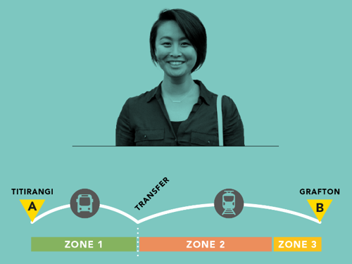
Cathy travels by bus and train across three zones from Titirangi to Grafton
Cathy travels by bus and train across three zones from Titirangi to Grafton. With her AT HOP card Cathy's adult fare will be $5.80. If she paid with cash Cathy's fare would be $10.00.
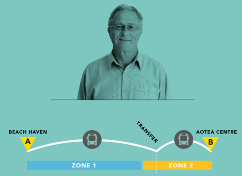
Patrick travels by bus across two zones from Beach Haven to the Aotea Centre
Patrick travels by bus across two zones from Beach Haven to the Aotea Centre. With his AT HOP card Patrick's adult fare will be $4.20. If he paid with cash Patrick's fare would be $10.00.
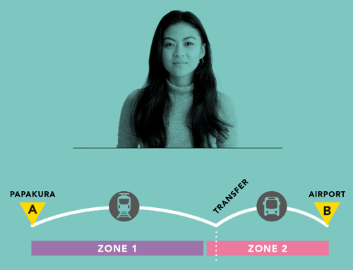
Kim travels by bus and train across two zones from Papakura to Auckland Airport
Kim travels by bus and train across two zones from Papakura to Auckland Airport. With her AT HOP card Kim's adult fare will be $4.20. If she paid with cash Kim's fare would be $10.00.