Safe Speeds Accelerate Programme Safe Speeds Accelerate Programme
As part of our commitment to make Auckland’s roads safer, Auckland Transport (AT) is implementing new speed limits in a number of areas. These areas include rural roads, newly built roads, areas where development is already happening, or areas where we are being proactive and preparing for future development, and around schools.
- Find out the outcome and next steps for this programme.
- Find out which roads were included in the Safe Speeds Accelerate Programme.
Project status: Partially complete / Consultation
Project zone: Region wide
Project overview
Speed limits have to match the conditions of the road and environment.
For example, rural roads are often unsealed, have unsegregated lanes, can be windy and narrow, and even experienced drivers can make mistakes. We have taken into account the layout and geometry of the roads and the surrounding land use to make an informed decision to reduce the speed limit. We consider the new speed limits to be safe and appropriate speeds.
In urban areas, or where development is taking place, we have to prepare for an increase in traffic numbers and vulnerable road users, or improve safety for the road users already there. More houses and shops mean more people. If the circumstances (such as land use) change, we have to change the speed limit to suit the change and create a safe environment.
It will take time and investment to upgrade or engineer the road network to a standard where the impact of a crash is minimised. In addition to being a critical component of road safety, reducing speed is a cost effective, efficient and immediate way we can reduce the chances of accidents, and improve the outcome for people involved in a crash.
As part of the Safe Speeds Accelerate Programme in 2018, we proposed new speed limits for certain roads in the areas below.
Speed limit changes
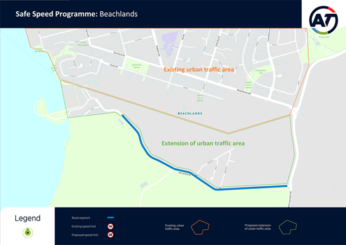
Beachlands
- Jack Lachlan Drive, the existing 100km/h section will be lowered to 60km/h.
At the same time, the Beachlands urban traffic speed zone of 50km/h will extend to cover the land between Beachlands and Jack Lachlan Drive in response to the development occurring in this area.
Dairy Flat
- Dairy Flat Highway (from 160 metres west of Silverdale Offramp Northbound (SH1) to 250 metres north of Kahikatea Road will be reduced from 100km/h to 80km/h).
- Dairy Flat Highway (from 250 metres north of Kahikatea Flat Road to 130 metres south of Horseshoe Bush Road will be reduced from 100km/h to 60km/h).
- Pine Valley Road (from Dairy Flat Highway to Old Pine Valley Road will be reduced from 100km/h to 80km/h).
- Kahikatea Flat Road (from 1300 metres west of Dairy Flat Highway to 300 metres west of Dairy Flat Highway will be increased from 70km/h to 80km/h)
- Kahikatea Flat Road (from 300 metres west of Dairy Flat Highway to Dairy Flat Highway will be reduced from 70km/h to 60km/h).
- Horseshoe Bush Road (from 60 metres west of Dairy Flat Highway to Dairy Flat Highway will be reduced from 70km/h to 60km/h).
- Dairy Flat Highway (from 130 metres south of Horseshoe Bush Road to 130 metres south of Foley Quarry Road will be reduced from 100km/h to 80km/h.
The crash study confirmed speeds as a contributing factor to the severity of crashes. The reduced visibility and high speed impact forces of crashes along this section of road has contributed to the seriousness of injuries.
The new speed limits will help improve safety and consistency with the posted speed limit and the safe and appropriate speeds.

Flat Bush
- Murphys Road - the existing 80km/h section between Ormiston Road and just south of Flat Bush School Road will be lowered to 60km/h.
- Flat Bush School Road - the existing 100km/h section east of Murphys Road will be lowered to 50km/h.
- Mcquoids Road - the existing 100km/h section east of Murphys Road will be lowered to 50km/h.
- All new subdivision roads connected to the above sections of road will also be set at 50km/h.
The land use in the area is changing from rural to urban, so we have to implement speed limits that take into account development and an increase in traffic volume and vulnerable road users.

Freemans Bay
To complement upgrades to Franklin Road and create a friendlier environment for people:
- Franklin Road, for the full length of the road, will be lowered from 50km/h to 40km/h.
- Adjacent side roads in the area around Franklin Road will also be lowered from 50km/h to 40km/h.

Golfland Drive
We are implementing a school zone speed limit/outside Elim Christian College Junior Campus on Golfland Drive.
A speed limit of 40km/h will apply to parts of:
- Golfland Drive.
- Corta Bella Place.
The 40km/h speed limit will apply during drop-off and pick-up times on days when the school is open. The operating times of the school zone are based on the scheduled start and finish times of the school.
In the morning, the speed limit applies from 35 minutes before the start of school until the start of school. In the afternoon, it applies from 5 minutes before the end of school until 15 minutes after the end of the school day.
At all other times the existing 50km/h speed limit will apply.

Kauri Flats
- Walters Road, the existing 70km/h section will be lowered to 50km/h.
- Grove Road, the existing 70km/h section will be lowered to 50km/h.
The speed limit change will accommodate development taking place, and the expected increase in traffic volume and vulnerable road users.

Mahurangi West
As these roads are very narrow, we intend to set a 40km/h speed limit in the residential area:
- Part of Mahurangi West Road.
- Jamieson Road.
- Barr Road.
- Opahi Bay Road.
- Rangi Road.

Māngere
- Ascot Road - the entire length of the road will be lowered to 50km/h.
- Montgomerie Road - the entire length of the road will be lowered to 50km/h.
The new speed limit is more suited to an urban environment, and will make the area safer for vulnerable road users.

Massey West
- Birdwood Road (From Red Hills Road will be reduced from 100km/h to 60km/h).
- Chamberlain Road (From Birdwood Road to 28 Chamberlain Road will be reduced from 100km/h to 60km/h and from 28 Chamberlain Road to 50 metres west of Tiwara Drive will be reduced from 100km/h to 50km/h).
- Mudgeways Road (entire length of the road will be reduced from 100km/h to 60km/h).
- Yelash Road (entire length of the road will be reduced from 100km/h to 40km/h).
The new speed limits will help improve safety on these rural roads.

Matakana North
- Matakana Valley Road (From 216 Matakana Valley Road to 960 Matakana Valley Road, will be reduced from 100km/h to 80km/h).
- Matakana Valley Road (From Smith Road to 960 Matakana Valley Road, will be reduced from 100km/h to 60km/h).
- Smith Road (entire length of the road, will be reduced from 100km/h to 40km/h).
- Ward Road (entire length of the road, will be reduced from 100km/h to 40km/h).
- Govan Wilson Road (entire length of the road, will be reduced from 100km/h to 40km/h).
The new speed limits will help improve safety on these rural roads.

Ōtāhuhu
To complement planned town centre improvements:
- Great South Road, between Princes Street and Park Avenue, will be lowered from 50km/h to 30km/h.
- Parts of Hall Avenue, Mason Avenue, Station Road, Gordon Road, King Street, Avenue Road, and Criterion Street, extending from the sides of Great South Road will also be included in the 30km/h zone.

Parau
- Huia Road - the existing 70km/h section at the southern end of Parau will be lowered to 50km/h.
- Shirley Road - the entire length of the road will be lowered to 50km/h.
The change will improve safety for drivers and pedestrians.

Pukekohe South
Reducing speed limits on the following roads in the area between the southern edge of Pukekohe and the Waikato District boundary.
- Upper Queen Street - between Woodlands Road and the Pukekohe urban 50km/h area, the existing 100km/h section will be lowered to 50km/h.
- Upper Queen Street - between Woodlands Road and the Waikato District boundary, the existing 100km/h section will be lowered to 80km/h.
- Tuakau Road - between Ray Wright Road and the Pukekohe urban 50km/h area, the existing 100km/h section will be lowered to 80km/h.
- Bayly Road, Ray Wright Road and Tuakau Road - along the sections that sit on the boundary of Auckland Council and Waikato District Council, a speed limit of 80km/h will be set to match the speed limit set by Waikato District for these roads.
- Woodlands Road - for the entire length of the road, the existing 100km/h section will be lowered to 60km/h.
- Webb Street - for the entire length of the road, the existing 100km/h section will be lowered to 60km/h.
- Quarry Road - for the entire length of the road, the existing 100km/h section will be lowered to 60km/h.
Urban speed limits will extend to the northern section of Upper Queen Street in response to the development occurring in this area. The changes to the other roads between the urban edge and the Waikato District boundary are to better match the speed limits to the layout, geometry and function of these roads and take account of the adjacent land use. It will also bring the speed limits in this area in line with those set by the Waikato District Council on the adjacent roads to the south.

Silverdale
- East Coast Road (From Hibiscus Coast Highway to 2181 East Coast Road from 80km/h to 60km/h).
The new speed limit will accommodate the area’s growing subdivision, and the related increase in traffic volumes and vulnerable road users.

South-East Warkworth
- Hepburn Creek Road (entire length of the road, will be reduced from 100km/h to 40km/h).
- Wilson Road (From Hepburn Creek Road to the eastern end of Wilson Road, will be reduced from 100km/h to 40km/h).
- Edwards Road (entire length, will be reduced from 100km/h to 40km/h).
- Hodgart Road (entire length, will be reduced from 100km/h to 40km/h).
The new speed limits will help improve safety on these rural roads.

South-West Pukekohe
- Puni Road - the existing 70km/h section will be lowered to 60km/h.
- Puni Road - the existing 100km/h section north of Rowles Road will be lowered to 60km/h.
The urban traffic area each side of Puni Road will also be extended. All existing roads within the extension of the urban traffic area will be lowered to 50km/h and a speed limit of 50km/h will be confirmed for all new roads built as part of subdivisions.
The planned change to Puni Road is an interim measure and it is likely that this will be lowered further to 50km/h once development of the adjacent land has progressed.

Swanson South
- O’Neills Road (From Pooks Road to Drower Road, will be reduced from 70km/h to 50km/h).
- O’Neills Road (From Drower Road to Christian Road, will be reduced from 100km/h to 60km/h).
- Christian Road (From Swanson Road to 10 Christian Road, will be reduced from 80km/h to 50km/h).
- Christian Road (From 10 Christian Road to the northwest end of Christian Road, from 80km/h to 60km/h).
- Welsh Hills Road (entire length, will be reduced from 80km/h to 60km/h).
- Tram Valley Road (entire length, will be reduced from 100km/h to 60km/h).
- Pooks Road (From O’Neills Road to 140 Pooks Road, will be reduced from 70km/h to 50km/h).
The new speed limits will help improve safety on these rural roads.

Tawharanui Peninsula
- Takatu Road (From Leigh Road intersection to 2km east of Baddeleys Beach Road, will be reduced from 100km/h to 80km/h).
- Takatu Road (From 2km east of Baddeleys Beach Road to Tawharanui Regional Park, will be reduced from 100km/h to 60km/h).
- Baddeleys Beach Road (From 55 Baddeleys Beach Road to the southern end of Baddeleys Beach Road, will be reduced from 100km/h to 40km/h).
- Baddeleys Beach Road (From 55 Baddeleys Beach Road to Takatu Road, will be reduced from 100km/h to 80km/h).
- Buckleton Road (entire length of the road, will be reduced from 60km/h to 40km/h).
- Bishop Lane (entire length of the road, will be reduced from 100km/h to 40km/h).
- Clinton Road, Kookaburra Drive, Pigeon Place and Campbell Road (entire length will be reduced from 50km/h to 40km/h).
- Haywood Lane (entire length of the road, will be reduced from 100km/h to 40km/h).
- Whitmore Road (from Takatu Road to 1.3km north of Bishop Lane, will be reduced from 100km/h to 60km/h).
- Whitmore Road (from 1.2km north of Bishop Lane to Buckleton Road, will be reduced from 100km/h to 40km/h)
The new speed limits will help improve safety on these rural roads.

West Tāmaki Road
Implementing a school zone speed limit outside Sacred Heart College on West Tāmaki Road.
A speed limit of 40km/h will apply to parts of:
- West Tamaki Road.
- Crossfield Road.
- Aragon Avenue.
- Courtland Avenue.
The 40km/h speed limit will apply during drop-off and pick-up times on days when the school is open. The operating times of the school zone are based on the scheduled start and finish times of the school.
In the morning, the speed limit applies from 35 minutes before the start of school until the start of school. In the afternoon, it applies from 5 minutes before the end of school until 15 minutes after the end of the school day.
At all other times the existing 50km/h speed limit will apply.

Project outcome
Most of the roads that we previously consulted on under our Safe Speeds Accelerate Programme have already had their speed limits reduced. Many of which were implemented on 30 June 2020 as part of the roll out of the Speed Limits Bylaw 2019. For information on the implementation of new speed limits on the roads from the Safe Speeds Accelerate Programme:
Download the Safe Speeds Accelerate Programme 2018 outcome (PDF 225KB, 10 pages).
However, there are 26 roads that were part of the 2018 Safe Speeds Accelerate Programme that we have had to review the speed limits for afresh under the Land Transport Rule: Setting of Speed Limits 2017. We are currently seeking public feedback on the proposed speed limit changes for these roads which are spread across the following areas:
- Swanson
- Massey
- Warkworth
- Matakana
- Tāwharanui Peninsula
Find out more information about these proposed changes.