Wellesley Street bus improvements - stage 2
We’re proposing changes to Wellesley Street between Albert Street, Victoria Park, and Beaumont Street to improve bus connections, journey times and safety.
On this page
Project details
Start date
2025End date
2030Location
CBD, Victoria Quarter – Wellesley St West and Beaumont StTransport involved
Walking, driving, bus and trainOverview
Wellesley Street is set to become the primary east-west public transport link through mid-town.
Approximately 1,300 buses currently travel along Wellesley Street every day, including 120 to 140 buses per hour during peak times.
That number is expected to increase to more than 2,200 buses per day by 2032 including 200 buses per hour during peak.
We’re proposing changes to Wellesley and Beaumont Streets to enhance bus and train integration and provide for large numbers of buses and pedestrians.
We are proposing to:
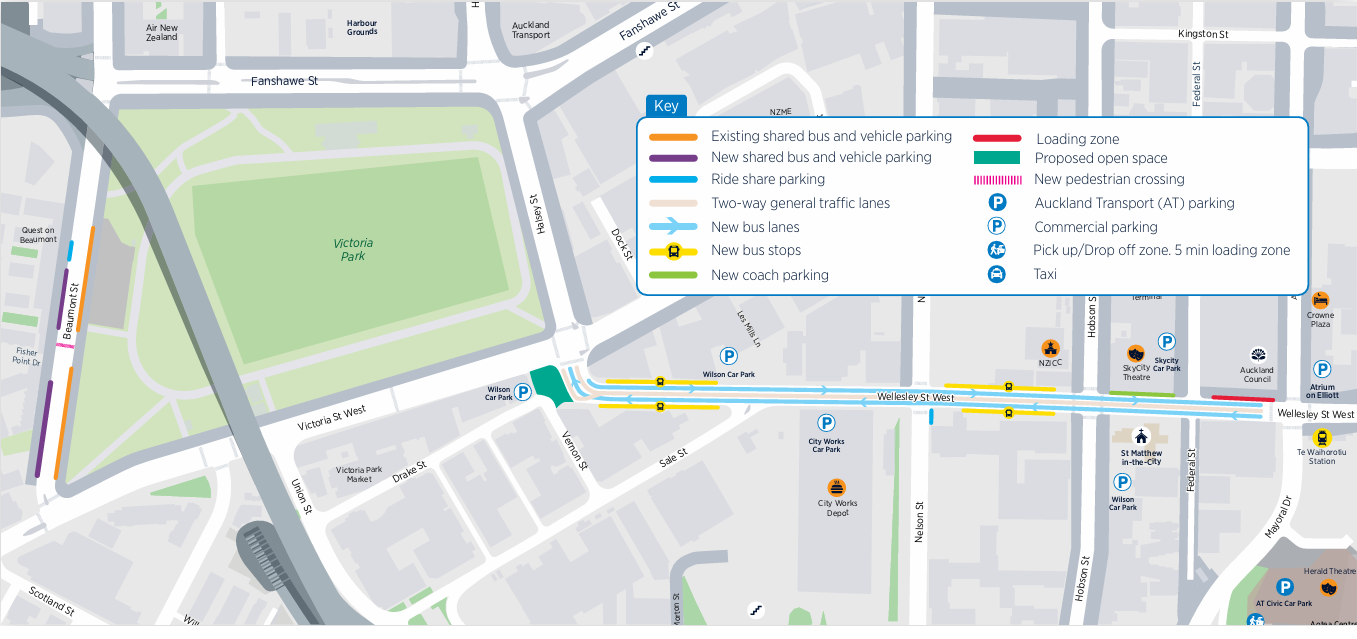
- introduce one bus lane in each direction along Wellesley Street between Albert Street and Victoria Park to improve journey times
- have one general traffic lane in each direction
- consolidate the bus stops and install new bus shelters along Wellesley Street for a better customer experience
- change the road layout at the bottom of Wellesley Street to make bus trips faster and more reliable and to improve safety
- extend the bus layover on Beaumont Street and install a signalised pedestrian crossing to make it safer to get to and from Victoria Park
- remove the right-hand turn from Wellesley Street into Federal Street South to improve safety and network efficiency.
Feedback closed
Project benefits

Faster, more reliable journeys

A safer experience

A better experience

Bus rail connection
Project background
With thousands of people expected to use Te Waihorotiu Station daily, Wellesley Street needs to be safe, efficient, and welcoming—whether you're walking, catching public transport, or spending time in the area.
The City Centre Masterplan 2020 identifies Wellesley Street as a key east-west bus route.
It connects the Learning Quarter, key city centre destinations, and Victoria Quarter, making it a vital part of Auckland’s transport network.
These improvements will:
- improve public transport connections, speed and reliability
- make it easier to access the Queen Street Valley, Aotea Arts Precinct, and Learning Quarter
- support economic growth and keep the city centre connected and accessible.
The City Centre Masterplan (CCMP) is Auckland Council’s unifying strategy, a 20-year vision that sets the direction for all city centre and waterfront projects.
Its purpose is to ensure that our city is shaped into a better-connected, greener, and more people-focused city we can be proud of.
A key concept of the CCMP is Access for Everyone (A4E). This new way of using our streets will allow pedestrians, cyclists, and buses to move freely while preserving access for vehicle trips needed to support the city centre, such as deliveries, construction, and emergency services.
It will open up new public spaces, create pedestrian-friendly links, and improve deliveries to businesses and residents.