Previous Harbour Crossing investigations Previous Harbour Crossing investigations
The Waitematā Harbour Connections project has been in planning and process for years. As it will provide a multitude of options of travel across the Waitematā Harbour, there has been many investigations and discussions on the best course of action for such a large project.
On this page
The latest thinking on another major crossing of the Waitematā Harbour proposes extending the suburban electric rail network and State Highway 1 beneath the seabed in tunnels to connect the North Shore with the Auckland CBD and beyond.
The Waitemata Crossing Study team have released the consultants report recommending a preferred route, having narrowed a long-list of 159 options to a short-list of three.
Waitemata Harbour Crossing Consultants Report (PDF 1.3MB)
The recommended option comprises four tunnels - two for trains and two for the motorway - east of Auckland Harbour Bridge. The Central Motorway Junction on the isthmus would link to the Northern Motorway, while the suburban rail network could in future be extended northward from the Auckland Central Business District to the North Shore.
The study was commissioned in 2007, so steps could be taken to safeguard a future transport corridor, if necessary, before the Wynyard Quarter was redeveloped.
It concluded that the use of driven tunnels gives the region flexibility as to the route and timing of project components, and future-proofs links with major transport infrastructural projects such as the CBD loop rail tunnel.
The rail connection from the north would run in deep tunnels east-west under the Wynyard Quarter, which would be served by an underground rail station. The motorway tunnels would largely bypass the precinct on its south-western corner.
The study did not canvas when a crossing might be built, or how it would be funded.
Project options
Recommended option
The cross-harbour tunnels would run underground just south of the Onewa Road interchange on the North Shore and reach the isthmus at depth under Westhaven Marina.
The rail tunnels (one track northbound, one southbound) would then travel eastward under Gaunt Street to link with a future CBD loop rail tunnel. There would be an underground station in Gaunt Street, between Daldy and Halsey Streets, to serve the Wynyard Quarter.
The twin motorway tunnels would form a new section of State Highway 1, with six lanes of general traffic (three northbound, three southbound). From Westhaven, the motorway would pass under Victoria Park before surfacing to link to the Southern and Northwestern motorways within the Central Motorway Junction.
Pedestrians and cyclists would be accommodated on the existing harbour bridge, which would continue to carry general traffic to Ponsonby and the CBD, but would cease to connect with the Southern Motorway. The Victoria Park flyover would be demolished.
Waitemata Harbour Crossing Map - Recommended Option 2c (PDF 222KB)
The estimated cost of the package is $3.7 billion to $4.1 billion.
A new crossing creates greater capacity, resilience and flexibility within the transport network.
The study says that an 80 per cent increase in person trips across the harbour is forecast by 2041. Currently about 26,000 people cross the harbour southbound in the morning two-hour peak period.
The study identifies passenger transport as having the most potential for increasing capacity. By 2041, passenger transport would cater for about 30 per cent of trips, up from the present 15 per cent.
An additional crossing on its own does not markedly diminish forecast road congestion levels. There would still be delays and queues at peak travel times.
The creation of a new route to carry the bulk of SH1 traffic offers flexibility for the transport system to evolve over time and maximise benefits of infrastructural investment. The existing harbour bridge, for example, could be used to extend the Northern Busway into the CBD, or the bridge ‘clip on' lanes could be removed altogether if that ever became necessary.
Rail and road components could be built at different times, if required.
Northern approaches in a nutshell
Both rail and road approach the harbour from the north on reclaimed land or on a structure at approximately the same level as the existing carriageway of the Northern Motorway (between Esmonde and Onewa Roads).
The cross-harbour driven tunnels (four separate bores) begin south of Onewa Road. There could be road connections to the new crossing at Akoranga Drive, Fred Thomas Drive and Onewa Road.
Cityside connections in a nutshell
Rail tunnels travel under Gaunt Street to link with a future CBD loop rail tunnel, and therefore through to the suburban rail network (existing and future extensions).
Motorway tunnels reach ‘cut and cover' tunnels under Victoria Park, bringing motorway traffic to the surface, with tunnel portals south of Cook Street (within the existing motorway corridor).
Southbound traffic from the harbour bridge exits at Ponsonby, and Fanshawe and Cook Streets.
The already proposed Victoria Park Tunnel links northbound traffic from the Wellington Street on-ramp to the bridge.
A new ‘cut and cover' tunnel under Victoria Park links southbound traffic from the bridge to Cook Street.
Changes in thinking
The recommended route is a variation on the Esmonde Rd-Wynyard Point route short-listed late in 2007. The main developments in thinking since then are:
- Driven tunnels are much less disruptive than a bridge or ‘cut and cover' tunnels.
- The ability for the suburban electric rail to cross the harbour in future should be preserved because it provides greater regional connectivity, and greater capacity than buses.
- Disruption at Wynyard Point, which is about to be redeveloped, can largely be avoided (though the rail tunnel alignment and station site would need to be protected for future construction).
- A vehicular crossing provides more regional connections and economic benefits than a crossing dedicated only to buses or trains.
A Grafton Gully connection
After the Westhaven-Onewa alignment, the next best performing option is a series of long tunnels (two motorway, two rail), with vehicular traffic linking to the Southern and North-western motorway at Grafton Gully (east of the CBD).
The rail tunnels would diverge from the more eastern road alignment under the harbour at a point east of Princes Wharf, and reach the isthmus at depth under Albert Street and link to a future CBD loop rail tunnel.
This option is more expensive and complex to build. The estimated cost is $4.7 to $5.1 billion.
However, the study notes that even if the motorway went to Grafton Gully, rail could take the Onewa-Westhaven route in order to provide the economic and transport benefits associated with a rail station at Wynyard.
The Grafton Gully option is the best place to bring north and southbound traffic into the motorway network, as it would connect with the Southern Motorway south of the Central Motorway Junction. It may also offer opportunities for urban renewal in the Beach Road area, where there would need to be extensive demolition during construction.
Bridge not recommended
The study says a wide-decked bridge could carry general traffic, trains and pedestrians/cyclists on the Onewa-Westhaven route.
A bridge would technically be the easiest to build, and less expensive, but is not a recommended option as it would be the most socially and environmentally disruptive to the CBD waterfront and St Mary's Bay. The main loss would be the Westhaven marine precinct, at least in the form it is known today.
Why the study was undertaken
The former Auckland Regional Council and NZ Transport Agency (formerly Transit New Zealand ) announced that the region was embarking on a study to determine a preferred transport corridor for another major Waitemata crossing.
It is widely recognised that bringing such a major infrastructure project to fruition in future requires a high level of regional co-operation.
Urban renewal on the waterfront makes it prudent and timely for the region to progress plans for a further harbour crossing, although it is not expected to be required until at least 2020.
Both the former Auckland City Council and the ARC had proposed district plan and coastal plan changes providing for the redevelopment of Wynyard Quarter.
NZTA's work to date, building on earlier studies adopted by the Regional Land Transport Committee, had concluded that a tunnel carrying rapid transit as a priority, running parallel to the east of the harbour bridge, could enter the CBD beneath Wynyard Point.
The study will help determine whether there is regional support for the NZTA board's conclusions that such a corridor should be protected by formal designation.
If the Wynyard corridor is preferred by the region, NZTA will be able to safeguard the site by lodging a Notice of Requirement to designate the necessary land.
At a practical level, this would be lodged early 2008 so hearings on the plan changes and designation could be held at the same time.
Phase One of the study
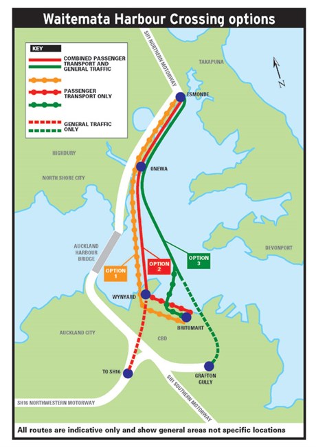
Phase one of the study, concluding in November 2007, proposed a short-list of priorities for further investigation. These include variations on three options:
- A crossing for only passenger transport between State Highway 1 (at Esmonde Rd) on the North Shore and the western CBD.
- A crossing for vehicles and passenger transport between SH1 (at Esmonde Rd) on the North Shore to the western CBD
- A tunnel linking SH1 (at Esmonde Rd) on the North Shore to the eastern CBD
The second phase of the study aims to narrow the short-list to a single-preferred option by early 2008.
Unused options and confirmation
Options that didn't make the short-list
-
Crossings west of the existing bridge did not create a strong public transport connection with the CBD. This helped eliminate Te Atatu, Rosebank, Waterview, Pt Chevalier, Meola and Western Springs.
-
Bayswater/Stanley Point, and the wider Devonport peninsula, are not identified as growth nodes in the Regional Growth Strategy and any crossing connecting to those locations would have major adverse social effects.
-
A route through the middle of Shoal Bay, Northcote Point had the most adverse environmental impacts.
-
A crossing to Resolution Point (near the Parnell Baths) would create severance issues between the CBD and Tamaki Drive and be a more expensive, longer crossing option.
-
Tunnelling a connection through to Panmure /Glen Innes would have significant adverse environmental effects and the highest cost.
-
A crossing to Highbury (Glenfield Road) had high adverse social effects and cost .
-
A bridge to the east of the CBD is unrealistic because of the required height clearance for ships.
-
Simply crossing the harbour from edge to edge isn't enough - connections to the wider road network were stronger at Esmonde, Wynyard and Grafton than from crossings to Onewa, Westhaven, Queens Wharf or Tamaki Drive.
Confirm and future-proof
The ARC's Transport Policy Committee in September 2007 recognised and supported the urgent need to undertake the study to confirm and ‘future proof' a preferred alignment and provide certainty for communities on both sides of the Waitemata Harbour.
Resolutions at that meeting included:
- That crossing options affecting the Western Reclamation including Victoria Park must not compromise the ability to achieve a high quality, sustainable urban form.
- That crossing options must be consistent with the vision and goals set out in the regionally agreed ‘Auckland Waterfront Vision 2040'.
- That the positive and negative effects of an additional harbour crossing on the economic well-being of the region be part of the study, and that timing considerations and the ‘shadow effect' of prolonged delay be part of the economic aspect of the study.
- That tunnel crossing options to the Eastern side of the Central Business District in the Stanley / Plummer Street area be one of the priorities for further study.
Background: 1997 to 2004
Current ARC policy has been informed by research carried out for the 1999 Regional Land Transport Strategy (RLTS), which concluded that the SH1 southern motorway could not be improved to the match the increased capacity from a new crossing - hence, a new motorway corridor across the isthmus would be required.
This implied that developing appropriate connections for new crossing would likely be more challenging than the crossing itself.
Two options for a new corridor were identified:
- A western alignment (via SH16 and SH20)
- A route roughly following the alignment of the former Eastern Transport Corridor, connecting with SH1 at Mt Wellington.
Based on this research, both the 1999 and 2003 Regional Land Transport strategies said a new crossing, should it be required in future, would be located in the vicinity of the existing bridge and connected by way of tunnel to SH16 north-western motorway, and from there to the future western corridor via SH20 (which is now under construction).
Subsequent investigations by Transit (now NZTA) in 2003 identified two preferred alignment options, both meeting the requirements of the RLTS:
- a bridge via Northcote Point west of the existing bridge
- a tunnel option via Wynyard Quarter from south of Onewa Road on the North Shore
The Regional Land Transport Committee (RLTC) considered the Transit study and resolved in March 2004 that Transit undertake further investigations to the point where a Notice of Requirement could be lodged. A key motivation for the RLTC in wishing to progress investigations was concern that the tunnel option via Wynyard Quarter might no longer be possible once the area was developed.
Around the same time, it was confirmed that the Regional Land Transport Strategy would have to be reviewed as a result of legislative changes. Amongst other matters, the new legislation meant that RLTS no longer specifies particular projects.
Thus, the current 2005 RLTS refers only to the need to "protect the ability to construct roading infrastructure that may be required beyond the term of the RLTS".
The option via Wynyard Quarter was considered by the ARC's Regional Strategy and Policy (RSP) committee at the meeting 20 March 2006 in the context of proposals for the future development of Quarter and changes required to the District Plan. At that meeting the RSP committee resolved that any new option of a new crossing in the Western Reclamation should not compromise the ability to achieve a high quality, sustainable urban form.