Asquith Avenue, Rossgrove Terrace and Baldwin Avenue Station rail level crossings
We’re making plans to replace western rail level crossings with safer connections.

On this page
Project details
Start date
March 2026End date
TBCLocation
Mt AlbertTransport involved
Walking, driving and cyclingOverview
To find safer, smoother ways to keep you moving as the city grows and more trains are needed, we’re planning for the future of the Asquith Avenue, Rossgrove Terrace, and Baldwin Avenue rail crossings.
It is part of the Western Rail Crossings Programme, to allow more frequent trains while keeping traffic moving, improving safety and supporting urban development.
This group of rail crossings are close together in a mostly residential area. They provide important access to Baldwin Avenue Station, and connect the local community to destinations like schools, cafes, malls and workplaces.
The crossings are used by both local traffic and people travelling longer distances. However, there are alternative routes nearby for longer trips. This means any changes need to focus on maintaining easy local access, rather than prioritising through traffic.
Latest updates
Feedback closed on 28 September 2026
We engaged with the community on potential options being considered at the rail crossings at:
- Asquith Avenue
- Rossgrove Terrace
- Baldwin Avenue Station.
Across the project area, we:
- dropped posters and brochures
- posted letters to nearby property owners
- door-knocked local businesses
- held 5 community engagement events and 4 focus group sessions.
Thank you to everyone who shared their thoughts in person or online. The engagement report will be available soon.
The options we are considering for replacing the rail crossings
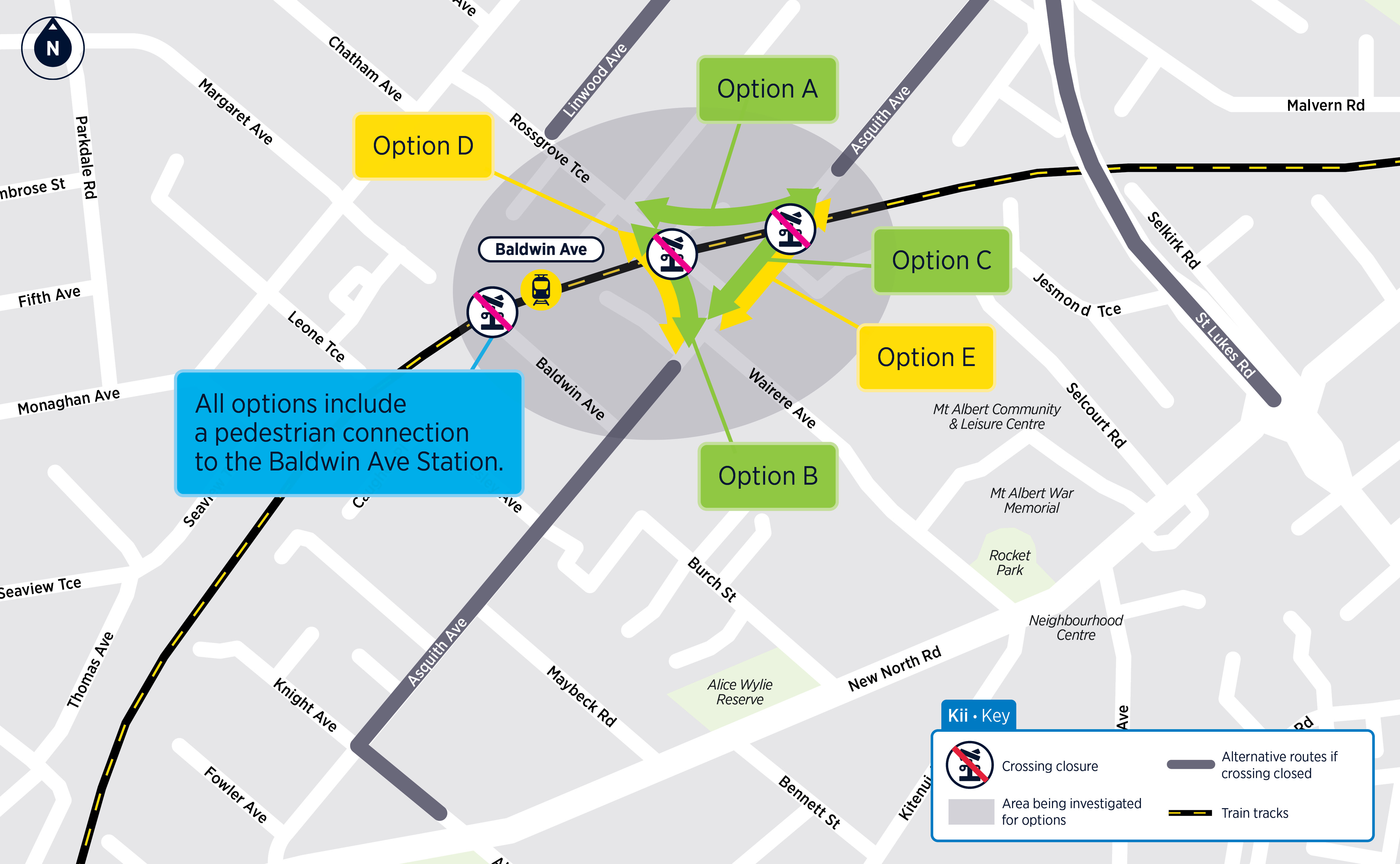
Option A: Local road to the north of the rail line connecting Rossgrove Terrace and and Asquith Avenue, plus a pedestrian bridge to access Baldwin Avenue Station (no vehicle crossing)
- Traffic will need to use alternative routes (St Lukes Road and New North Road) to cross rail line and reach Mt Albert.
- Relatively small construction “footprint” compared with other options.
- Estimated construction timeframe of 12 to 18 months.
- Likely to be the cheapest option.
Option B: Road bridge over rail line between Rossgrove Terrace and Asquith Avenue with connection to Baldwin Avenue Station
- Complex build in a residential area with large construction footprint and big structure.
- Estimated construction timeframe of 2 to 3 years.
- Road bridge options likely to be similar levels of cost.
Option C: Road bridge over rail line at Asquith Avenue plus separate pedestrian bridge to access Baldwin Avenue Station
- Traffic to use St Lukes Road and New North Road to get to Mount Albert.
- Complex build in a residential area with large construction footprint and big structure.
- Estimated construction timeframe of 2 to 3 years.
- Road bridge options likely to be similar levels of cost.
Options with more significant trade-offs to consider
Option D: Underpass between Rossgrove Terrace and Asquith Avenue for people and vehicles, plus pedestrian access to Baldwin Avenue Station
- Significantly complex build in a residential area with large construction footprint.
- Estimated construction timeframe of around 3 to 4 years.
- An underpass is likely to be more expensive than a road bridge option.
Option E: Underpass under the rail line at Asquith Avenue for people and vehicles, plus pedestrian access to Baldwin Avenue Station.
- Significantly complex build in a residential area with large construction footprint.
- Opportunity to maintain access to Rossgrove Terrace.
- Estimated construction timeframe of around 3 to 4 years.
- An underpass is likely to be more expensive than a road bridge option.
Options that we investigated and decided not to progress
Full closure of all crossings
Why we will not progress this option: Loss of connectivity, and the ability of Baldwin Avenue Station to function.
Closure with active mode (walking and cycling) connection
Why we will not progress this option: Loss of vehicle connections and cutting off the nearby residential area.
Rail overbridge or underpass
Why we will not progress this option: Much higher cost and disruption with limited additional benefit. Poor value for money.
Underpass at Knight Avenue
Why we will not progress this option: Unsuitable topography and flooding issues.
Timeline
Investment case
During the next two years, we’ll identify the preferred approach to replace western rail level crossings with safer connections, and how to prioritise when they’re built. This is key to developing an investment case to seek funding for future phases.
This stage includes:
- Technical assessments: such as traffic and pedestrian counts, safety audits, ground investigations, environmental and flood analysis, and urban design studies. We’ll consider past trends, current conditions and future needs.
- Community input: we’ll engage mana whenua, local boards, elected members, schools, businesses and communities to understand how crossings are used today and what’s needed for the future.
We’ll share what we find to support discussions about potential options, including key constraints and trade-offs. Community feedback will help shape the preferred approach for each crossing.
Statutory approvals
After an approved investment case, the next step will be to seek funding for statutory approvals. These are needed to consent or protect the land required for a future crossing.
Protecting land now means that projects can be constructed in stages as funding is available.
It also provides property owners, businesses and the community with certainty on where transport routes will be in the future. This can help people make informed decisions about their own land and the development of that land.
During this phase, we will:
- Engage one-to-one with directly affected landowners.
- Continue working with elected members, mana whenua and stakeholders.
Detailed design and construction
Designs will continue to be refined through targeted engagement in this phase.
Construction will be staged according to network needs. While we expect to start replacing some rail crossings in the Inner West from early to mid-2030s, timeframes are dependent on funding.
During this phase, we will:
- Engage one-to-one with directly affected landowners.
- Continue working with elected members, mana whenua, and key stakeholders.
- Communicate clearly with communities about construction timing, disruption, and how we'll manage the impacts of construction.
Feedback closed
Project background
The next 20 to 30 years will see more people living, working and studying close to the rail corridor, especially train stations. That means more people taking trains, walking and cycling to stations and more activity around the rail corridor.
Replacing rail crossings with safer connections is key to unlocking the full City Rail Link benefits of allowing even more trains to run in the future while making it safer and easier to get around your local area. It also supports urban development.
If we don’t replace level crossings people may take more risks as barrier arms are down more often and there will be increased congestion, impacting the economy.
From March 2026, we engaged with our partners, stakeholders, businesses and local communities. We shared information about the Rail Level Crossings Programme and heard initial feedback. Groups we talked to included:
- local government representatives, like local boards and councillors
- mana whenua representatives
- transport advocacy organisations
- community stakeholders, like schools and business associations
- residents and commuters, who regularly use rail crossings.
What we've heard from the community
Across the Mount Albert Cluster, we received 1098 survey responses. We heard that:
- these crossings are seen as a connected group that supports daily travel, especially for walking and cycling. Crossings need to be considered together, not individually
- recent growth and development are increasing pressure on the area
- people want changes considered carefully to maintain access, consider issues on surrounding roads and plan for future growth.
Asquith Ave
We received 444 survey responses for Asquith Avenue.
We heard that this route is an important and well-used local connector, but high levels of through traffic place pressure on an otherwise narrow residential street.
We also heard that it is important to:
- maintain convenient and direct access for local trips
- improve road layout, visibility, and safety to reduce conflicts between users
- provide safe, clear, and accessible walking and cycling facilities that can handle high use
- ensure surrounding roads and intersections continue to operate well without added congestion
- build and open any new connection before closing the existing crossing.
Rossgrove Terrace
We received 384 survey responses for Rossgrove Terrace.
We heard that this is an essential and valued local connection, providing a key route across the rail line, but its importance means it is heavily relied on for daily travel.
We also heard that it is important to:
- maintain strong east–west access across the rail line for everyday travel
- improve safety, visibility and crossing conditions, especially during school and station peak times
- ensure surrounding roads and intersections continue to work well and avoid added congestion
- provide a smooth and well-connected link to Baldwin Station, with easy movement on both sides of the rail line
- safely manage high volumes of people, particularly during school and commuter peaks
- deliver clear, safe and high-quality walking and cycling facilities that can handle heavy use
- build and open any new connection before closing the existing crossing.
Baldwin Ave
We received 270 survey responses for Baldwin Avenue.
There was strong support to retain connection in this location. Feedback suggested Baldwin Ave is the safest and most trusted pedestrian crossing in the area, providing a key connection to the station and local destinations, but its importance has increased following nearby closures.
We also heard that it is important to:
- keep a pedestrian connection in this location (or close by) to maintain access across the rail line.
- make sure the new connection is just as direct and easy to use for everyone, including wheelchairs, prams and bikes.
- keep good access to Baldwin Station, with easy movement between both sides of the platform.
- provide a safe, high-quality path for walking, cycling and other small, wheeled users, designed to handle lots of people.
- build and open the new connection before closing the existing crossing.
We know from HOP card data that a high proportion of station users at Baldwin are children, secondary or tertiary students (around 45%), highlighting the importance of safe and reliable walking access for everyday school travel.
These crossings are close together, meaning any change at one crossing would affect traffic, access and safety at the others.
The surrounding area is mostly residential, so large changes to the road or rail environment could result in visual, noise and property impacts.
Raising road levels in this area could affect natural flood paths, potentially displacing flood water and creating wider impacts beyond the immediate site.
Maintaining safe access to Baldwin Station, including for high volumes of people walking and cycling, is an important consideration, as the station plays a key role in local travel.