Links to Glen Innes
The Links to Glen Innes project is about creating more options for people to travel safely and sustainably in our growing communities.
On this page
Project details
Start date
October 2015End date
Mid 2026Location
Glen InnesTransport involved
Walking, driving, bus, train and cyclingOverview
Around 5,100 new homes are expected to be built in Glen Innes over the next decade. This growth is supported by major investment into new community facilities, stormwater systems, underground utilities, and the road network.
AT is supporting this growth by giving people more options to travel sustainably and safely, whether by car, bike, bus, train or on foot. The new cycleway connects to:
- neighbouring suburbs
- Te Ara ki Uta ki Tai / Glen Innes to Tāmaki Drive Shared Path
- the public transport network.
To minimise disruption, we're coordinating construction with routine road and footpath maintenance.
We'll also be collaborating and coordinating with other organisations doing works in Glen Innes including:
- utility providers
- Watercare
- housing developers
- Kāinga Ora
We will maintain access for residents and businesses throughout the works. Follow the detour route signage carefully and plan ahead for any travel delay times.
Latest updates
We need to do repair works at the Taniwha Street and Line Road roundabout, as well as widen the Bradley Lane kerb to make it easier for trucks to turn to Taniwha Street from Bradley Lane.
We’ll start working from Friday 3 April 2026.
It will take about 2 weeks to complete this work. However, unforeseen weather conditions may delay the start or end of the works.
To minimise disruption, we’ll be working in two stages:
- Stage 1: Taniwha Street and Line Road roundabout (Western side) and Bradley Lane.
- Stage 2: Taniwha Street and Line Road roundabout (Eastern side).
After completing works at the Taniwha Street and Line Round roundabout, we need to resurface Line Road, including the Line/Taniwha roundabout surrounding areas.
We’ll be in touch with impacted residents and businesses once the further details about this work has been confirmed.
For more information, download:
Timeline
Merton West Cycleway
In September 2025, we informed the community that we are taking time to review parts of the Merton Road design, between College Road and Morrin Road.
We have completed the review and are now planning to start construction around mid-2026.
We will build the cycleway based on the design that was previously consulted on. This design provides the best overall safety and cycling network benefits for the community.
The changes include:
- installing a unidirectional cycle lane on both sides of Merton Road, between College Road and Morrin Road
- reducing parking on the northern side of Merton Road to accommodate the cycleway - parking will be retained on the southern, Colin Maiden Park side of the road.
For more information, see Merton West Cycleway map (PDF,2.4MB).
To minimise disruption, we also will complete routine maintenance, and renewal works at the same time.
This will include:
- kerb and footpath upgrades on the northern side of the road (residential side)
- renewed road surface.
Why are we making these changes?
The section of cycleway on Merton Road, between College Road and Morrin Road, is the last 5% of the Links to Glen Innes project.
Completing this section will unlock opportunities for people of all ages and abilities to ride to the shops, sports facilities, and the Glen Innes Train Station.
For you and your family, this brings:
- more safe transport choices
- the ability to cycle from east to west, as well as between Stonefields and Glen Innes
- in the long term, improved mental and physical wellbeing of the community builds resilience, eases traffic and pollution, and supports mode shift.
We understand that changes like these can be challenging and we are committed to undertaking cycling events and activities in the area to encourage cycling uptake.
Once more information is available, we be in touch with residents, businesses and people travelling through the area.
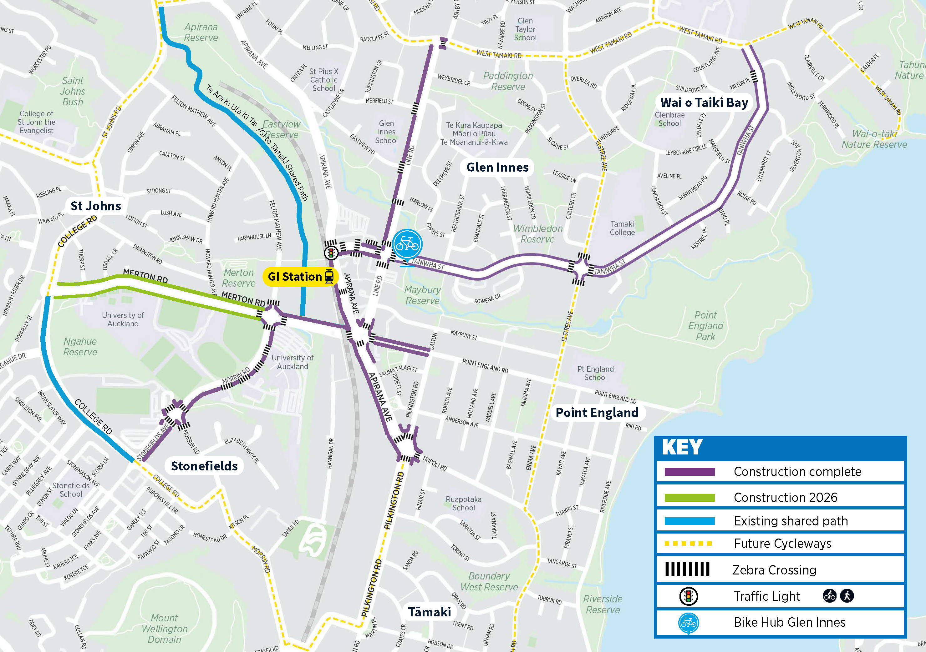
Section by section progress
- Taniwha Street between Line Road and West Tāmaki Road
Completed in November 2023.
Watch a video about the construction at Taniwha Street. - Taniwha Street between Apirana Avenue and Line Road
Completed in December 2024. - Apirana Avenue between Taniwha Street and Pilkington Road
Completed in July 2024. - Point England Road between Line Road and Dalton Street
Completed in November 2024. - Stonefields Avenue
Completed in March 2025. - Morrin Road
Completed in March 2025. - Pilkington Road, Apirana Avenue and Tripoli Road roundabout
Completed in August 2025. - West Tamaki Road
Completed in August 2025. - Line Road
Completed in November 2025. - Merton East Cycleway
Completed in December 2025. - Merton Road, Point England Road, Apirana Avenue roundabout
Completed February 2026.
Project designs
Project benefits

Cycling network improvements

Bus stop improvements

Pedestrian improvements

Supporting growth in cycling
Project background
Public consultation was undertaken in 2015, 2017, and 2022 to ensure the design of the new cycleways was in partnership with the community.
Feedback has helped us identify key routes and ways we can improve outcomes for future users.
Where to place your bins if your street has a new cycleway
Put your bins out on your grass berm. If your berm is steep or there's no grass berm, put them between the concrete islands alongside the cycleway.
Getting a bike to use the cycleway
If you need to learn how to safely ride and maintain your bike, check out our cycling & walking resources for free courses and events.
If you need a bike, visit the local Glen Innes Bike Hub at 204 Taniwha Street. You can buy a safety-checked second-hand bike, and bike parts and accessories. The Glen Innes Bike hub also offers free access to tools and advice on basic bike maintenance.