Getting around the City Centre in Tāmaki Makaurau / Auckland
The city centre is becoming greener, safer and well-connected. Explore bus, train and ferry options, driving & parking, and walking & cycling routes.
There will be key changes to the City Centre transport network as major projects are under construction.
The estimated timelines are shown below. All dates are subject to change, and may be dependent on project consultation, funding and approval.
| Date | Change |
| Current |
Temporary traffic management will change frequently to suit the changing needs of construction sites and businesses nearby. There may be occasional delays or lane diversions in addition to those listed on this page. Construction teams will be on hand to help you move safely around construction sites.
|
| Early 2025 |
Albert Street reopens to general traffic. Western buses move to Albert Street. |
These changes are to support the delivery of the City Centre Masterplan and Access for Everyone.
The City Centre is served by several different bus routes. If you are planning to bus into the City Centre, the following bus route changes may be useful for you to know.
New WX1 service
From November 2023 the new Western Express (WX1) service will connect Westgate, Lincoln Road and Te Atatū to the City Centre. It will run every 10 minutes during peak hours until 7pm, and then every 15 minutes until 11:30pm.
In the City Centre, the WX1 will stop at Karangahape Road, then head along Queen Street where the services will terminate. All outbound services will commence from the Lower Albert Street interchange. Find out more about the WX1 service.
Western and north-western bus changes
Once the City Rail Link overground construction finishes in early 2025, western and north-western buses, including the WX1, will return to Albert Street, terminating at the Lower Albert Street interchange.
The Waitematā (Britomart) train station connects the City Centre to West, East and South Auckand.
Planned maintenance and the Rail Network Rebuild
If you are planning to travel to the City Centre by train, the Rail Network Rebuild may impact your journey. KiwiRail is currently rebuilding the ageing foundations across Auckland's rail network. This work is being done one section at a time, over the next 3 years.
Eastern Line: Until January 2024, the Eastern Line is closed between Waitematā Station (Britomart) and Ōtāhuhu. We're providing alternatives such as rail replacement buses and express services.
Find out more about the Rail Network Rebuild.
To view planned maintenance on the rail network, check the Planned Rail Closures page.
To view the status of your train in real-time, view Train Line Status in AT Mobile.
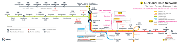
Download a map of Auckland's current train network (PDF 2MB)
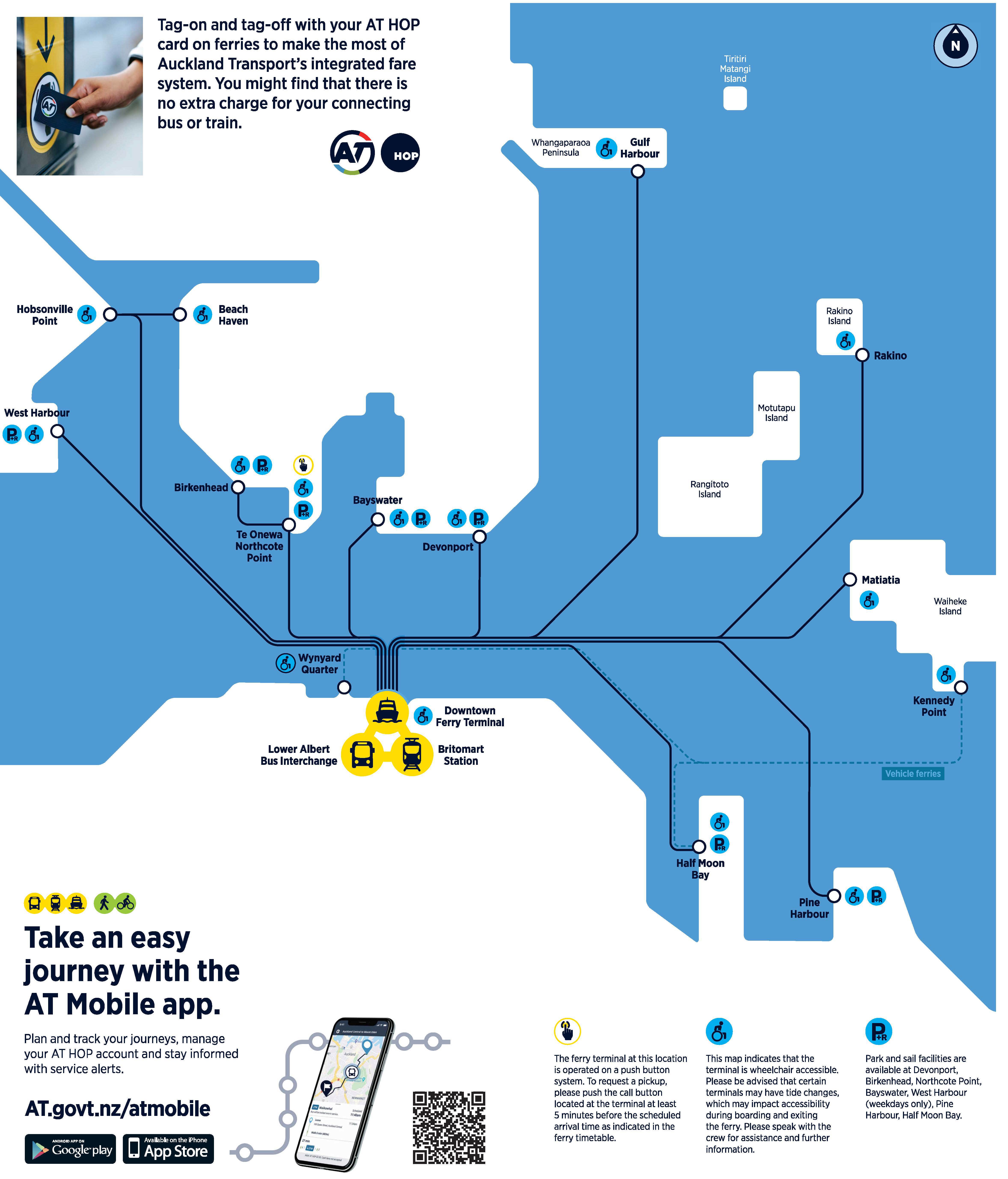
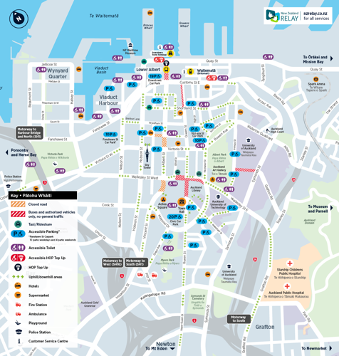
The Downtown Ferry Terminal on Quay Street connects the City Centre by ferry to many locations around Auckland.
From 1 October 2023, the Gulf Harbour and Half Moon Bay ferry services will be operating on reduced timetables. Find out more about the changes to Auckland's ferry services.
The map below shows Auckland's current ferry network.
We're shifting the City Centre from a place people 'go through' to a place people 'go to', by changing the way City Centre streets are used.
Local traffic zones will help prioritise business, residents and visitors to the area. Unless necessary, private vehicles will be encouraged to enter and exit the City Centre from its edges and avoid going through the city.
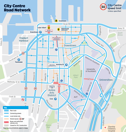
Download the City Centre road network map (PDF 230KB)
Recommended driving routes to the City Centre
- Driving from the North map (PDF 280KB)
- Driving from the South map (PDF 278KB)
- Driving from the East map (PDF 280KB)
- Driving from West map (PDF 280KB)
Queen Street
Queen Street between Wellesley Street and Wakefield Street has become an Authorised Vehicles Only (AVO) area.
Only public transport buses, goods and emergency vehicles are allowed to drive on this section of Queen Street. The section is closed to private vehicles, taxis and car share services.
The AVO applies 24 hours a day, 7 days a week. If you enter the AVO with an unauthorised vehicle, you'll receive a $150 infringement fee.
Learn more about the Queen Street changes.
Wellesley Street
From 15 April 2024, Wellesley Street between Elliot Street and Queen Street will only be open to buses between 7am and 7pm. Outside of those hours, it will be ‘authorised vehicles only’ meaning goods vehicles will be able to use the road.
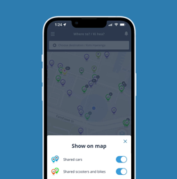
Shared cars
You can now find and book shared cars, scooters and bikes in the AT Mobile app. Just select the toggle icon in the bottom right corner of the home screen and select your preferred mode.
If you are planning to drive and park in the City Centre, check the City Centre carparks page for parking options before you leave.
Download the AT Park app for up-to-date information, parking availability and payments.
The Civic Carpark has a new pickup/drop off zone located on level 1 as you enter the carpark from either Greys Avenue or Mayoral Drive. The pickup/drop off zone is clearly marked to make it easy for passengers and drivers to locate.
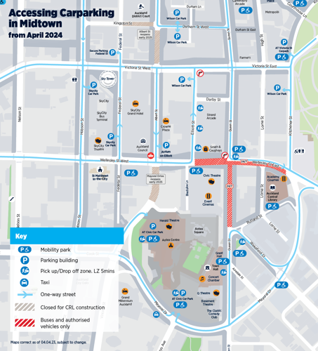
From Mid-December 2023, temporary road layouts and traffic management changes will be in the Midtown area due to City Rail Link construction. All neighbouring parking buildings remain open and accessible, but access to Wilson Parking Elliott Street will be from Elliott Street only (the service lane entrance will be temporarily closed).
Download the Accessing Midtown Parking map (PDF 179KB) to help you navigate the area to your parking location.
Victoria Street Carpark trade/service parking
Trade and service vehicles are able to access nine reserved spaces located on the ground floor of the Victoria Street carpark. These are available at hourly rates.
Loading and servicing
The AT Park app has up-to-date information on City Centre Loading Zones, parking availability and payments.
Download the Loading and Servicing Zones in Midtown map (PDF 158KB) to show Loading Zones available in the area.
Please note: From mid-December 2023, loading zones in Midtown may move temporarily due to City Rail Link and other construction projects. Follow the roadside signs to the marked locations.
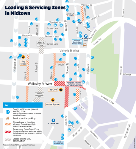
As part of a wider AT plan to ensure there is enough parking for loading & servicing in the City Centre, several new loading and servicing zones are being implemented.
Find out more about the Loading and Servicing Management Plan.
We are transforming the City Centre to create more space for pedestrians and people on wheels.
Roadworks across the City Centre may temporarily impact the quality of walking and cycling routes, but access will always be maintained.
Queen Street
The Wai Horotiu project is converting traffic lanes to an expanded space for people to walk, cycle and scooter safely. This is part of the Wai Horotiu Queen Street Project.
Albert Street
Between 2023 to 2025, construction between Wellesley Street and Wyndham Street may cause diversions. Access to all shops, businesses and residences will be maintained.
Safe cycle routes
If you are planning to bike in the City Centre, download the City Centre Cycle Loop map to see the shared paths, cycle lanes and bike parking available.
Shared scooters and bikes
You can now find and book shared cars, scooters and bikes in the AT Mobile app. Just select the toggle icon in the bottom right corner of the home screen and select your preferred mode.
Public transport accessibility
Visit the Accessible Travel page for more information about travelling on public transport in Auckland if you have access needs or limited mobility.
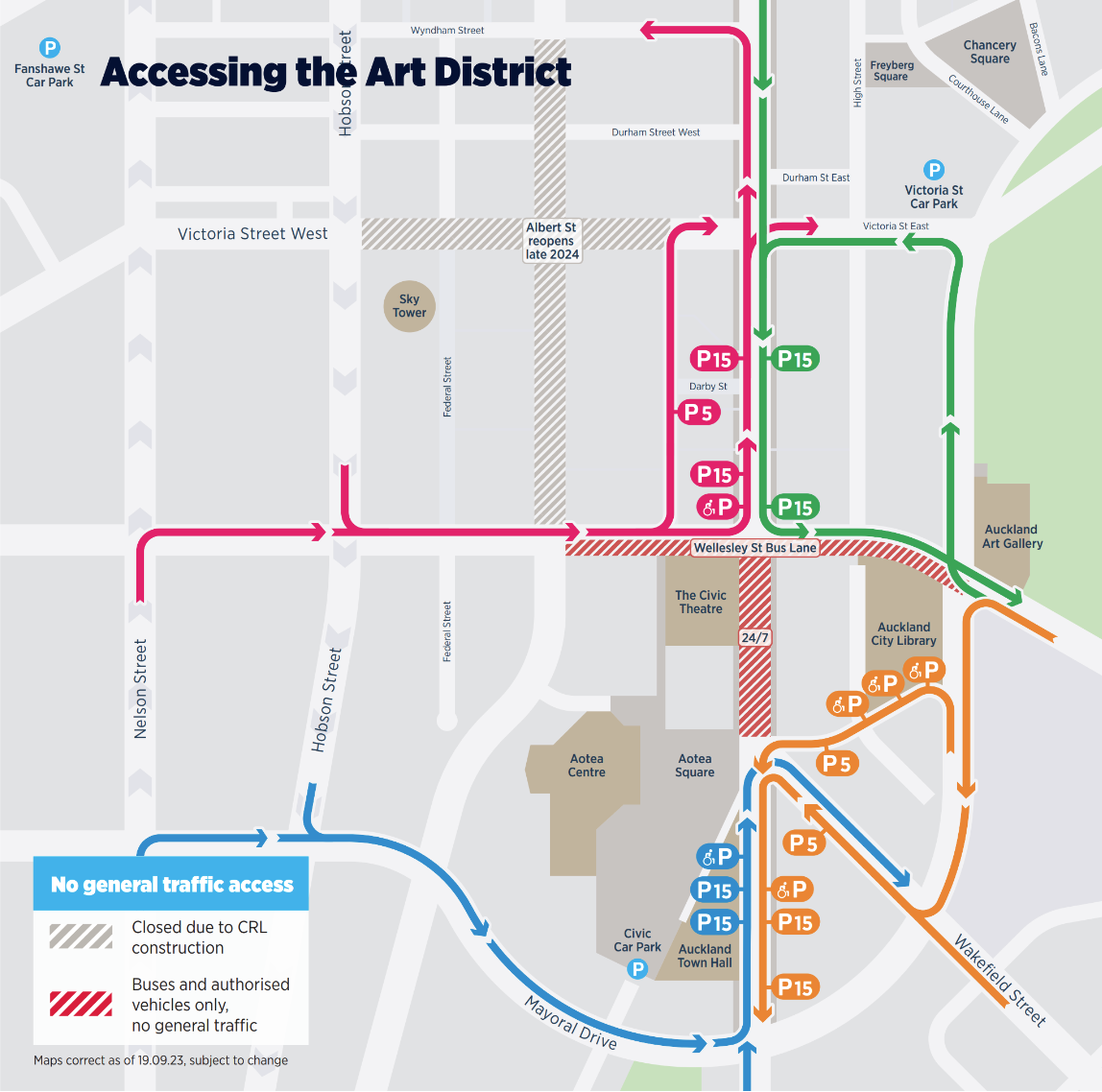
City Centre accessible areas map
This map shows how to reach mobility spaces and key areas in the City Centre if you have access challenges or limited mobility.
Download the City Centre accessible areas map (PDF 179KB)
Civic Carpark drop off/pickup zones
The Civic Carpark has a new pickup/drop off zone located on level 1 as you enter the carpark from either via Greys Avenue or Mayoral Drive. The pickup/drop off zone is clearly marked to make it easy for passengers and drivers to locate.
The map below shows the locations of other mobility parking and pickup/drop off areas around the art district.
Download the AT Mobile app
Add AT Mobile to your device to plan your journey to and around the City Centre.