Wellesley Street Bus Improvements Wellesley Street Bus Improvements
The new Te Waihorotiu Station will transform Wellesley Street into a major transport interchange. This project is part of Auckland Transport’s work to create a greener, safer and better-connected city centre for everyone.
- Project overview
- The Wellesley Street Bus Improvements project
- Public feedback
- Loading zones and servicing
- Next steps
- Reference material
Project overview
When the City Rail Link opens in 2026, Te Waihorotiu Station at Aotea Square will be one of 2 new train stations in the city centre. Wellesley Street will become a thriving pedestrian and entertainment destination and new gateway to the city. Thousands of people will arrive by train and high-frequency bus routes, making Wellesley Street an important transport interchange, just like Lower Albert Street and Britomart in the downtown area.
Over the next decade, improvements to Wellesley Street will be delivered in 3 stages:
- Stage 1 – Queen Street to Albert Street (Construction starts 15 April 2024 and will be completed by late 2025)
- Stage 2 – Albert Street to Victoria Park
- Stage 3 – Queen Street to the Learning Quarter.
Background
Aucklanders want to access and move around the city centre safely and with ease, whether they’re living there, working there or visiting the area. Auckland Transport (AT) will improve bus reliability, frequency and access with an upgraded interchange, Te Waihorotiu Station.
The new train station will make Wellesley Street a main route for buses travelling east–west and an arrival point for thousands of people coming into the city by train.
The Wellesley Street Bus Improvements project will include upgrading the underground utilities and rebuilding the road and footpaths. AT will build 4 new bus shelters, widen the footpaths, improve pedestrian crossings, improve loading zones, and create seating and amenities in public spaces around the new station.
Stage 1
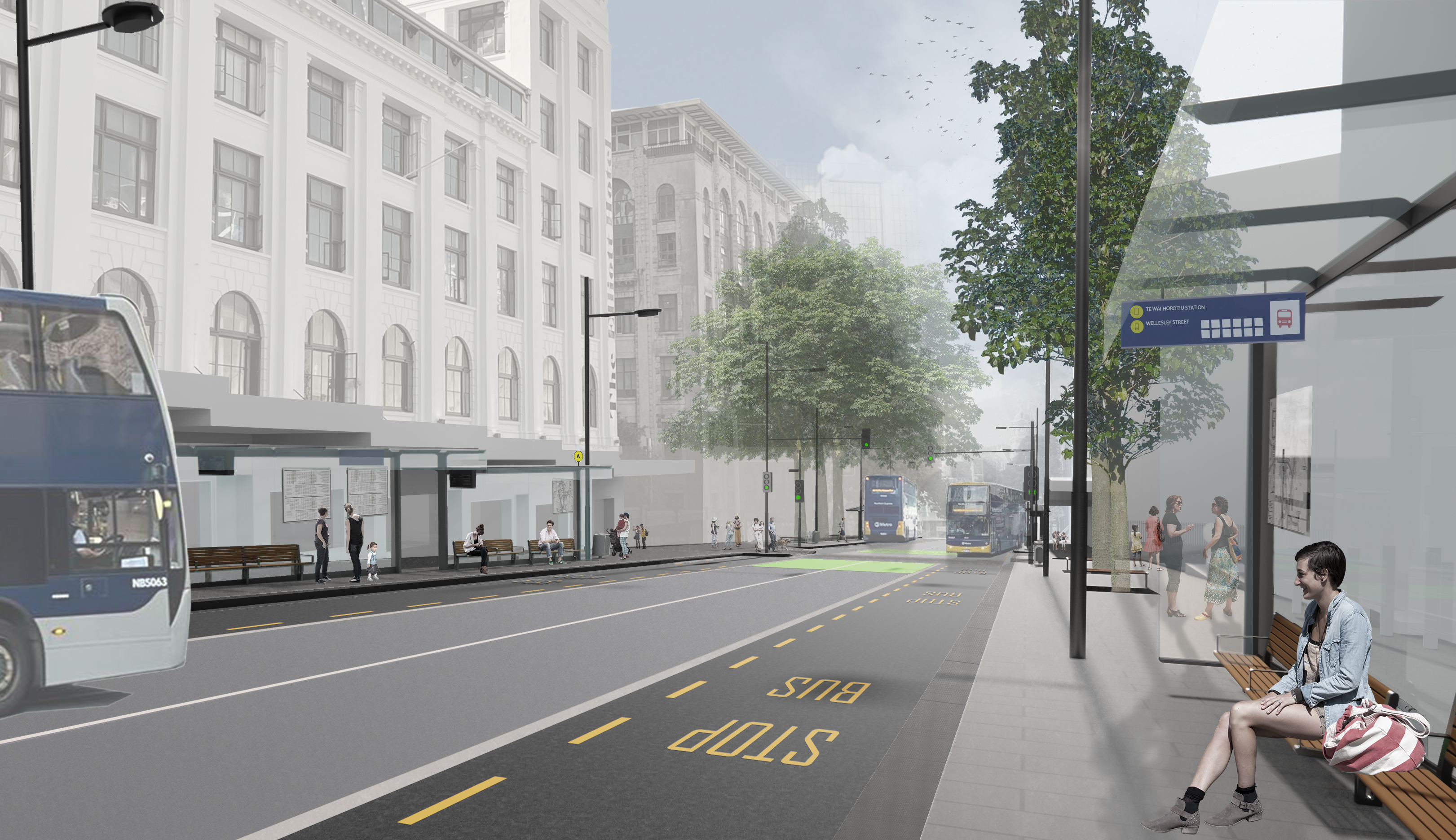
AT will upgrade Wellesley Street between Albert Street and Queen Street. As passengers board their bus or exit Te Waihorotiu Station, they’ll see a significantly improved Wellesley Street, with wide open pavements for ease of movement, large bus shelters, public seating and established trees. The new-look Wellesley Street will recognise the diverse needs of its citizens while acknowledging its past, reflected in new artwork.

Artist’s render of Wellesley Street South
Artist’s render of Wellesley Street West from the corner of Mayoral Drive
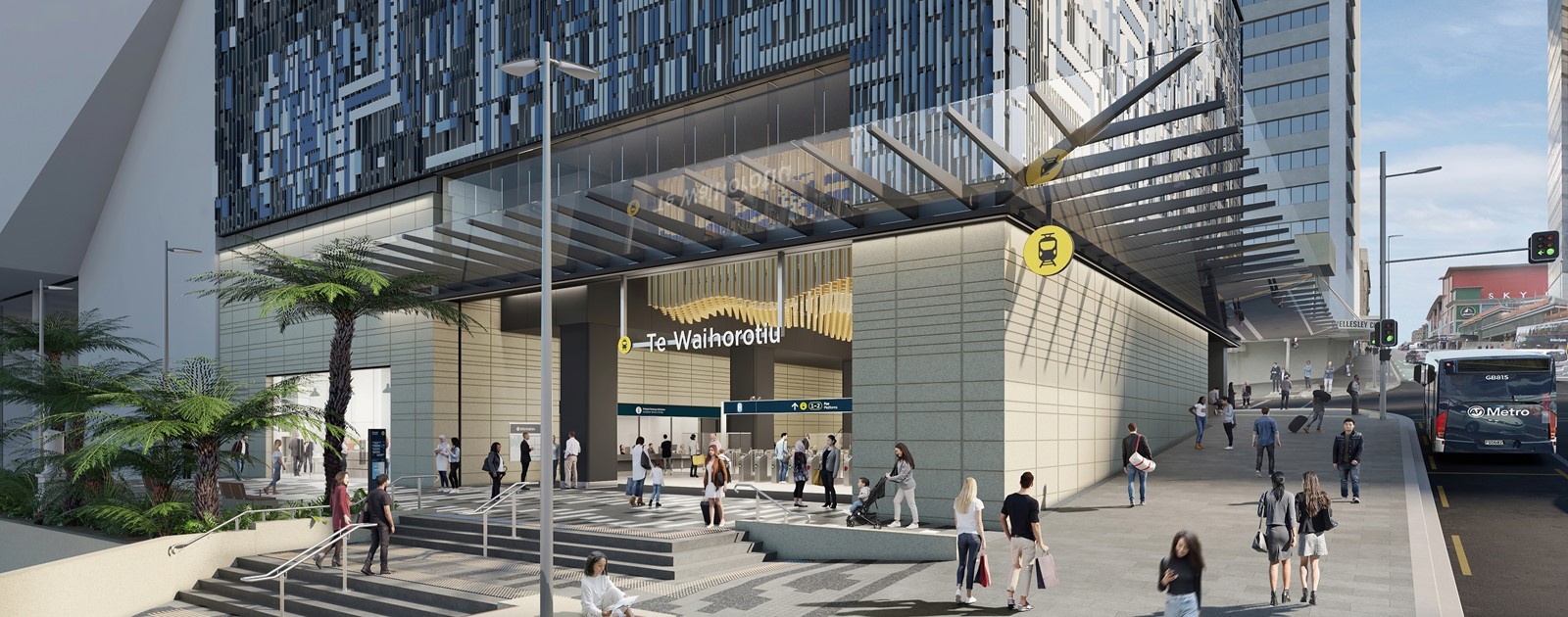
Progress of Te Waihorotiu Station, which will have an entrance on the corner of Albert Street and Wellesley Street, is well under way, with street-level works soon to be completed. Stage 1 of the Wellesley Street Bus Improvements project will provide seamless links between the station, bus network and midtown area.
The design for stage 1 includes:
- improved bus facilities for a high volume of passengers
- wider footpaths for the expected increase in foot traffic with the opening of Te Waihorotiu Station, bus operations, and future business and residential development
- an improved mid-block crossing between Bledisloe Lane and Elliot Street
- a new road layout for a faster, more efficient public transport network
- underground utility upgrades
- new seating and quiet spaces
- improvements to Queen Street loading zone
- new water fountain
- additional tree protection
- new paving and road surfacing.
Stages 2 and 3
Stages 2 and 3 have yet to be designed but will progress when funding has been confirmed.
Construction plan
Work for Stage 1 (between Queen Street and Albert Street) is starting on 15 April. To enable these works, from 4 June 2024, the road will be closed to cars and will be bus only between 7am and 7pm, 7 days a week.
Outside of these hours, authorised vehicles only (for example, commercial or emergency vehicles) may use the road. Pedestrian and business access will be maintained.
Please note: Temporary traffic management will change frequently to suit the changing needs of construction sites and nearby businesses. There may be occasional delays or diversions on footpaths or lanes. Construction teams will be on hand to help you move safely around construction sites. Visit Getting around the city centre for the latest updates and advice.
Four bus stops outside the Civic will be temporarily moved to stops nearby. These stops, on Wellesley Street between Queen Street and Albert Street, will be well signposted. For details, see service announcements related to Wellesley Street Bus Improvements.
During the estimated 18-month construction period, vehicle access to Elliott Street and the Bledisloe House carpark will always be available.

Artist’s render of Wellesley Street North

Artist’s render of Te Waihorotiu Station
The Wellesley Street Bus Improvements project
The WSBI project responds to the City Centre Masterplan (CCMP) by removing buses from Victoria Street to allow for the Te Hā Noa Victoria Street linear park (Te Hā Noa). It’s also part of the proposed City Centre Bus Plan, which includes Wellesley Street becoming the east-west bus route through midtown. (Consultation on the City Centre Bus Plan closed on 24 October 2021.)
Ultimately, WSBI will deliver significant upgrades to bus infrastructure, the streetscape, and the pedestrian environment along the length of Wellesley Street between Victoria Park and Grafton Gully. These improvements will be implemented in stages over the next decade.
Consultations carried out as part of the CCMP and the project’s Indicative Business Case supported this central area of Wellesley Street becoming a bus-only section, and we are currently investigating how we can prioritise buses here while limiting other vehicle movement to local access and essential vehicles only.
Construction for Stage 1 (between Queen Street and Albert Street) is starting in April 2024 and will be complete in time for the opening of Te Waihorotiu Station. Streets will remain open while the works are completed, and the project team will work hard to minimise disruption in the area.
Auckland Council is building Te Hā Noa Victoria St Linear Park, which will be implemented in stages.
Find out more about Te Hā Noa Victora Street linear park.
Find out more about other central city projects.
Public feedback
From 6 October to 9 November 2021, AT and Auckland Council engaged with the public on Wellesley Street Bus Improvements and Te Hā Noa – Victoria Street. Currently under way, the Te Hā Noa – Victoria Street project will transform Victoria Street into a more pleasant environment, with more greenery and a safer road layout for walking and cycling.
Both projects are essential to the midtown regeneration programme. Engagement focused on how each project will help transform the midtown area and integrate with the space around Te Waihorotiu Station. We also looked at the road layout and operational issues.
Your feedback
Thank you for providing your feedback. Overall, there was a good level of support for both projects, and a number of themes came through in the submissions, summarised below. The full WSBI and Te Hā Noa – Victoria Street public feedback report (PDF 1.6MB) and demographic data (PDF 640KB) are now available.
We will continue to engage with key stakeholders as we commence construction.
Loading zones and servicing
Loading and servicing for local businesses and residents are critical elements of the day-to-day operation of the city centre.
We are working with local businesses and property owners on short-term support and long-term solutions, which will be consulted later in 2024 under the Room to Move in the City Centre parking strategy.
Next steps
Stage 1 construction is starting in April 2024 and is expected to be complete by late 2025. The project team will work closely with the Auckland Council Development Response Team to do everything possible to minimise the impact to businesses during construction.
Keeping in touch
To subscribe for project updates, email ATengagement@at.govt.nz and include ‘Wellesley Street Bus Improvements’ in the subject line.
For up-to-date information on all projects currently under way as part of the midtown regeneration programme, subscribe to Auckland Council’s regular newsletter using the QR code below. You can also visit Progress AKL: Midtown neighbourhood.

Reference material
The City Centre Masterplan
The City Centre Masterplan (CCMP) is Auckland Council’s unifying strategy, a 20-year vision that sets the direction for all city centre and waterfront projects. Its purpose is to ensure that our city is shaped into a better-connected, greener, and more people-focused city we can be proud of.
A key concept of the CCMP is Access for Everyone (A4E). This new way of using our streets will allow pedestrians, cyclists, and buses to move freely while preserving access for vehicle trips needed to support the city centre, such as deliveries, construction, and emergency services. It will open up new public spaces, create pedestrian-friendly links, and improve deliveries to businesses and residents.
City Centre Bus Plan
The proposed City Centre Bus Plan sets out the approach that Auckland Transport aims to take in planning for buses in Auckland’s city centre, to help deliver the outcomes of the CCMP.
Find more about the City Centre Bus Plan.