Te Ara ki Uta Ki Tai (Glen Innes to Tāmaki Drive shared path)
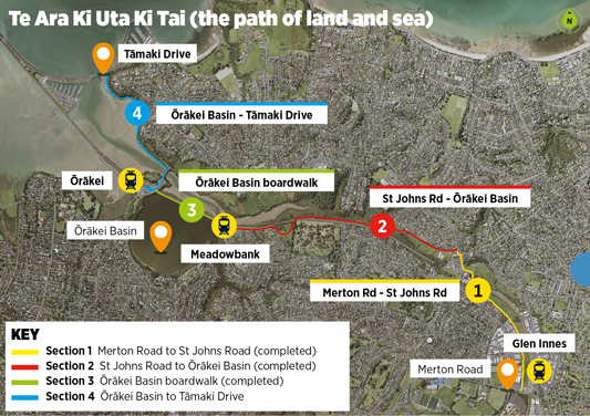
Te Ara Ki Uta Ki Tai – the path of land to sea – is a 7km long shared path from Merton Road near Glen Innes Station to Tāmaki Drive.
On this page
Project details
Start date
2016End date
End of 2026Location
Merton Road (Glen Innes) to Tamaki Drive (Orakei)Transport involved
Walking and cyclingOverview
‘Te Ara Ki Uta Ki Tai’ (the path of land and sea) is a 7km-long path that connects Auckland’s eastern suburbs to the Waitemata Harbour.
With 6km already completed from Glen Innes to Ōrākei Basin, the path has proved hugely popular. Alongside the more than 1,300 average daily users, the path has become a treasured community asset, connecting people to shops, schools and train stations along the way.
It’s also a recreational destination visited by families, running clubs and cycling enthusiasts from across Auckland.
The project has been delivered in 4 stages. The longest of the 4 sections, stretching 2.65km from St Johns Road to Ōrākei Basin (Section 2), was completed in May 2022. The final stage (Section 4) will provide the final link from Ōrākei Road to Tāmaki Drive, where it connects with other pathways around the bays and into the city centre.
Key features include:
- a wide 4m path, safely separated from road traffic
- low gradients and accessibility-friendly design to enable a wide range of users to enjoy it
- surface materials chosen to reduce the risk of slipping
- CCTV and lighting for safety and extended hours of access
- the path connects communities with public transport along the route.
Latest updates
We have appointed a contractor to work with us to plan the delivery of the pile replacement work. We will carry out further pile testing and survey investigations to help inform this. As part of the planning, we will be considering recycling or refurbishing parts of the existing structure — such as the deck and balustrades — to help manage costs and support sustainable outcomes. We will also carefully consider how best to maintain a connection for people walking and biking across the basin. A further update will be provided once we know more and ahead of work starting.
We installed the first decking beams at the Onepu Whakatakataka Reserve end of the shared path late last year. This is a major milestone.
Construction is happening from both ends — the reserve and Purewa Bridge, where the boardwalk connects to land. In this video, Fatima Leung-Wai, AT’s Construction Delivery Manager – Central and HEB site engineer, Mitva Patel talk about piling work.
We expect to finish the 870m concrete boardwalk by the end of this year. That will complete the full 7km path.
We have completed investigation and options assessment to address pile deterioration along a 230m section of the Orakei Basin Boardwalk.
This affects an original section of boardwalk where the piles are approximately 15 years old. We have now started planning and procurement to get work underway to replace the piles.
The preferred solution involves replacing all wooden piles along the boardwalk with steel piles to provide a long life and resilience (against toredo worm) well into the future.
To optimise costs and support sustainable outcomes, the intention is to recycle and refurbish structural elements where practicable, including the deck structure and balustrades.
Our goal is to complete the work in time for the Hobson Bay boardwalk opening at the end of next year (Section 4).
The speed we can deliver the work will depend on factors such as availability of materials and specialist contractors, any consenting requirements and weather and site conditions during construction.
We will provide an update when the construction timeline and details are confirmed. A key part of the planning for this phase is considering all options to retain access to this important community link during the replacement work.
Timeline
Section 4 — Hobson Bay Boardwalk construction
We are constructing an 870m-long boardwalk in Hobson Bay, connecting Orakei Road (near Purewa Bridge) to Onepu Whakatakataka Reserve (Ngapipi Road).
Delivering this boardwalk will complete the 7km long path.
Section 3 (Ōrākei Basin Boardwalk) maintenance
We have identified that some piles on a section of the boardwalk are deteriorated. As a safety precaution and to prevent damage to the underlying structure the affected section of boardwalk has been closed.
AT has completed a series of investigations and is now planning to replace the piles. Our focus is to identify a solution that is cost effective, resilient and will last well into the future.
Key documents
Project benefits

Safety and convenience

Accessibility friendly

Connected communities

Community input
Project background
Section 1 - Merton Road to St Johns Road
Completed.

Section 2 - St Johns Road to Ōrākei Basin
Completed.

A series of mahi toi (artworks) were unveiled in May 2024 along Section 2 of the path between Kohimarama Road and Ōrākei Basin. This includes 2 sets of pou (cultural markers) at the end of each path acting as waharoa (entranceways), and carved handrails at both ends of the 2 bridges.
All artworks relate to the central design theme ‘Te Ara Ki Uta Ki Tai’ (from the land to the sea). The 4.5m tall green and red waka pou at Ōrākei Basin are named Ki Uta and Ki Tai respectively. They mark the point between sections 2 and 3.
The pou at Kohimarama Road represent the inhabitants of the Pourewa Valley below, specifically the piwakawaka (fantail) and tuna (eel). Designs along the carved handrails show the connectivity of the path sections and te maunga (the mountain) and nga wai (the waters).


Section 3 - Ōrākei Basin boardwalk

Work is underway to complete Section 4, a spectacular 870m long boardwalk following the Hobson Bay coastline. The boardwalk will be constructed with concrete piles and decks with steel balustrades.
Starting next to Ōrākei Road (beside Purewa Bridge) it will follow the coastline to Onepu Whakatakataka Reserve to connect with the shared path we’ve already built on Ngapipi Road running through to Tāmaki Drive.
Completing the project will provide a continuous, safe and fully separated walking and cycling connection all the way from Glen Innes to Tāmaki Drive, enabling more people to use and enjoy the path.
The design was carefully developed, responding to our Mana Whenua project partner, stakeholder and community feedback.
The design:
- features concrete piles and deck, with a 1.2m steel balustrade
- ensures recreational water access is retained at the reserve
- complements the natural environment
- incorporates unobtrusive lighting (while still illuminating the path safely)
- provides views from the path to the surrounding area and natural environment
- has safe surfaces that minimise the risk of slipping
- has curves that are smooth for cyclists
- includes a rest area.
Boardwalk lighting and materials
The bridge and boardwalk will comprise a concrete deck and timber and steel balustrades with LED downlighting in the handrail.
To determine the alignment of the boardwalk in Hobson Bay, we have considered user comfort, the potential impact on neighbours, marine traffic, water access and use, environmental impact and sea-level rise.
Subtle materials, finishes and design details have been selected to naturally complement the coastal landscape and its curved form.
The main impacts of construction will be from:
- temporary traffic management beside Purewa Bridge on Ōrākei Road
- construction vehicle movements to and from our worksites on Ōrākei Road and Ngapipi Road.
Our work is carefully planned to minimise disruption on these busy commuter routes. Our temporary traffic management will include:
- stop and go or traffic lights when large machinery or plant is entering or exiting the worksites
- lane reduction and shoulder closures when working next to Purewa Bridge, maintaining two-way traffic flow
- a lower posted speed limit past work areas for everyone’s safety.
Disruption
There may be some noise or vibration felt from construction. We will have control measures on-site and will monitor this closely.
Our site compound in Ōrākei Train Station car park will impact the number of available car parks, but train services will run as normal.
Integral to the project at every stage is care to reduce the impact of construction and design the path in a way to complement the environment.
On Section 4, careful design has reduced the number and size of piles needed for the bridge and boardwalk, and a textured finish on the piles will encourage marine growth and a darkening appearance over time. This means the boardwalk will blend with the local environment and treads lightly. Where planting is removed because of construction, it will be replaced with natives to enhance the quality and diversity of habitat and support native wildlife.
As part of enabling works in September 2024 we have removed privet from near Purewa Bridge and she-oaks from Onepu Whakatakataka Reserve (Ngapipi Road), which we will replace with representative native species. The shared path alignment through Onepu Whakatakataka Reserve and planting will complement Ōrākei Local Board future aspirations to restore the reserve.
With many more people travelling through the area, the interim facility on Ngapipi Road is much needed until the boardwalk in Hobson Bay is constructed, creating an alternative route.
The 4.5m wide boardwalk will have smooth surfacing and low gradients making it a faster, more comfortable, and accessible route to take to and from Tāmaki Drive.
Ngapipi Road is a challenging location due to its topography, high traffic volumes, importance as a freight and bus route and lack of available space for new facilities. Space allows for a one-way cycle facility only, and the footpath has been widened as much as possible within the available space and other constraints.
If travelling north (toward Tāmaki Drive) people on a scooter or bike can use the uni-directional cycleway. If heading south, travelling on the outside edge of the shared path (further from vehicles exits) is encouraged.
Please travel safely at appropriate speeds for a shared space while using the route, be prepared to stop at driveways and bus stops and if walking, keep dogs on a short lead.