Speed limit changes in Auckland’s west and north Speed limit changes in Auckland’s west and north
Auckland Transport (AT) has set new safe and appropriate permanent speed limits for 26 roads in Auckland’s west and north. These changes were made as part of the Speed Limits Amendment Bylaw 2021 and came into force on 31 May 2021.
- Download the Statement of Proposal (PDF 343KB, 10 pages).
- Speed Limits Amendment Bylaw 2021 (PDF 3.12KB, 18 pages).
- Read the Speed Limits Bylaw 2019 (PDF 13.5 MB, 168 pages).
- Read the public feedback report
Project status: New speed limits on these roads came into force on 31 May 2021.
Project zone: North / West
Project overview
AT controls over 7,300km of road network and we are responsible for ensuring all roads under our control have speed limits that are safe and appropriate for their function, design, safety and use.
We identified 26 roads in the following areas that needed new safe and appropriate speed limits:
The AT Board decided to approve the Speed Limits Amendment Bylaw 2021 and as a result, speed limit changes on these 26 roads came into force on 31 May 2021.
Background
The speed limit changes on these 26 roads form part of our Safe Speeds Programme. We are currently working through a programme to review speed limits on all roads across our network to identify where changes are needed. These 26 roads were prioritised based on a number of criteria. Speed limit changes on other roads around Auckland will be considered in the future.
The Speed Limits Bylaw 2019 was made by Auckland Transport in 2019. New permanent speed limits came into force on a number of roads around Auckland on 30 June 2020. Find out more about the Speed Limits Bylaw 2019.
Timeline
- 9 November 2020 until 17 January 2021 - Seek public feedback
- 4 February 2021 - Hearings for those who requested to provide feedback in person or via an audio/visual link.
- February/March 2021 - AT road safety team considers public feedback and submits final proposal to AT Board.
- 29 April 2021 – The AT Board approved the Speed Limits Amendment Bylaw 2021
- 31 May 2021 – New speed limits on these 26 roads came into force
Roads we proposed changing the speed limits for
We proposed to set new permanent speed limits for the following roads in Auckland’s west and north, as part of an amendment to the Speed Limits Bylaw 2019.
Swanson
| Road name | Suburb | Section of road | Current speed limit (km/h) | Proposed speed limit (km/h) |
| Local Board: Waitākere Ranges | ||||
| Christian Road | Swanson | Between 140m south of Swanson Road and 65m southwest of Mettam Drive (UTA boundary*) | 80km/h | 50km/h |
| Christian Road | Swanson | Between 65m southwest of Mettam Drive (UTA boundary) and the southwest end of Christian Road | 80km/h | 60km/h |
| O’Neills Road | Swanson | Between the urban traffic area (UTA)* boundary (being approx. 475m south of Pooks Road) and Drower Road | 70km/h | 50km/h |
| O’Neills Road | Swanson | between Drower Road and Christian Road | 100km/h | 60km/h |
| Tram Valley Road | Swanson | Between Christian Road and 430m southwest of Christian Road (UTA boundary*) | 50km/h | 60km/h |
| Tram Valley Road | Swanson | Between 430m southwest of Christian Road (UTA boundary) and southwest end of Tram Valley Road | 100km/h | 60km/h |
| Welsh Hills Road | Swanson | Entire length of the road | 80km/h | 60km/h |
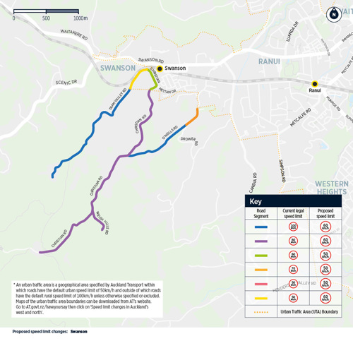
Massey
| Road name | Suburb | Section of road | Current speed limit (km/h) | Proposed speed limit (km/h) |
| Local Board(s): Waitākere Ranges and Henderson-Massey | ||||
| Birdwood Road | Massey | Between Red Hills Road and 190m northwest of Crows Road | 100km/h | 60km/h |
| Local Board: Henderson-Massey | ||||
| Chamberlain Road | Massey | Between Birdwood Road and 950m southwest of Tiriwa Drive | 100km/h | 60km/h |
| Local Board: Waitākere Ranges | ||||
| Mudgeways Road | Massey | Entire length of the road | 100km/h | 40km/h |
| Yelash Road | Massey | Entire length of the road | 100km/h | 40km/h |
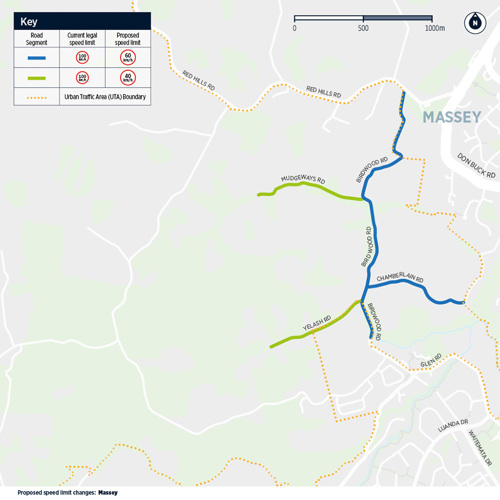
Warkworth
| Road name | Suburb | Section of road | Current speed limit (km/h) | Proposed speed limit (km/h) |
| Local Board: Rodney | ||||
| Edwards Road | Warkworth | Entire length of the road | 100km/h | 40km/h |
| Hepburn Creek Road | Warkworth | Between 540m south of Wilson Road (UTA boundary*) 610m south of Wilson Road (50m east of UTA boundary) | 100km/h | 50km/h |
| Hepburn Creek Road | Warkworth | Between 610m south of Wilson Road (50m east of UTA boundary*) and Edwards Road | 100km/h | 40km/h |
| Hodgart Road | Warkworth | Entire length of the road | 100km/h | 40km/h |
| Wilson Road (Warkworth) | Warkworth | Between Hepburn Creek Road and the eastern end of Wilson Road | 50km/h | 40km/h |
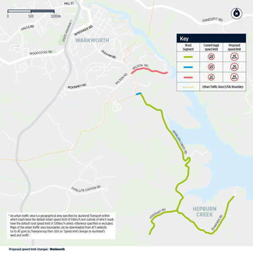
Matakana
| Road name | Suburb | Section of road | Current speed limit (km/h) | Proposed speed limit (km/h) |
| Local Board: Rodney | ||||
| Govan Wilson Road | Matakana | Entire length of the road | 100km/h | 40km/h |
| Matakana Valley Road | Matakana | Between 950m northwest of Leigh Road (UTA boundary) and 20m south of Smith Road | 100km/h | 80km/h |
| Matakana Valley Road | Matakana | Between 20m south of Smith Road and 2,720m south of Pakiri Road | 100km/h | 60km/h |
| Matakana Valley Road | Matakana | Between 2,720m south of Pakiri Road and Pakiri Road | 100km/h | 80km/h |
| Smith Road (Matakana) | Matakana | Entire length of the road | 100km/h | 40km/h |
| Ward Road | Matakana | Entire length of the road | 100km/h | 40km/h |
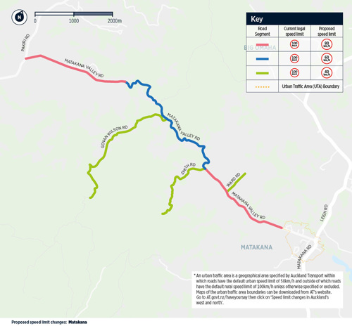
Tāwharanui Peninsula
| Road name | Suburb | Section of road | Current speed limit (km/h) | Proposed speed limit (km/h) |
| Local Board: Rodney | ||||
| Baddeleys Beach Road | Tawharanui | Between Takatu Road and 730m north of Clinton Road | 100km/h | 80km/h |
| Baddeleys Beach Road | Tawharanui | Between 730m north of Clinton Road and the southern end of Baddeleys Beach Road | 50km/h | 40km/h |
| Bishop Lane | Tawharanui | Entire length of the road | 100km/h | 40km/h |
| Buckleton Road | Tawharanui | Entire length of the road | 50km/h | 40km/h |
| Campbell Road | Tawharanui | Entire length of the road | 50km/h | 40km/h |
| Clinton Road | Tawharanui | Entire length of the road | 50km/h | 40km/h |
| Haywood Lane | Tawharanui | Entire length of the road | 100km/h | 60km/h |
| Kookaburra Drive | Tawharanui | Entire length of the road | 50km/h | 40km/h |
| Pigeon Place | Tawharanui | Entire length of the road | 50km/h | 40km/h |
| Takatu Road | Tawharanui | Between Leigh Road and 2000m east of Baddeleys Beach Road | 100km/h | 80km/h |
| Takatu Road | Tawharanui | Between 2,000m east of Baddeleys Beach Road and Tawharanui Regional Park entrance | 100km/h | 60km/h |
| Whitmore Road | Tawharanui | Between Takatu Road and 1,200m north of Bishop Lane | 100 km/h | 60km/h |
| Whitmore Road | Tawharanui | Between 1,200m north of Bishop Lane and 1,040m north of Buckleton Road** | 50km/h | 60km/h |
| Whitmore Road | Tawharanui | Between 1,040m north of Buckleton Road and Buckleton Road | 50km/h | 40km/h |
** Through the review process, AT recently discovered a 50km/h speed limit sign on Whitmore Road in the incorrect location. It was 350m north of Buckleton Road, whereas it should have been located 1200m north of Bishop Lane, as per the current Bylaw 2019. This has now been corrected.
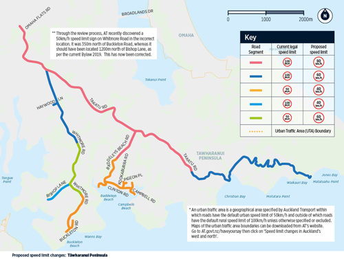
* An urban traffic area is a geographical area specified by Auckland Transport within which roads have the default urban speed limit of 50km/h and outside of which roads have the default rural speed limit of 100km/h unless otherwise specified or excluded. Maps of the urban traffic area boundaries can be downloaded from AT’s website. Go to AT.govt.nz/haveyoursay then click on ‘Speed limit changes in Auckland’s west and north’.
Download maps of the urban traffic area boundaries that are relevant to this proposal (874KB).
For further information on urban traffic areas, please refer to the Speed Limits Bylaw 2019 amendment (PDF 13.5MB, 168 pages).
The criteria for reviewing speed limits
When reviewing speed limits, there are a number of things we have to consider. The Land Transport Rule: Setting of Speed Limits 2017 requires AT to review speed limits to ensure they are safe and appropriate with regard to all of the following:
- The characteristics of the road and roadsides – e.g. Are there sharp bends? Are there blind corners? Is there a central median strip to provide a buffer zone between oncoming traffic?
- The crash risk for all road users
- The number of deaths and serious injuries
- The function and use of the road – this includes things like who uses the road and the speed vehicles travel at
- Traffic volumes
- Nearby land use
- The number of intersections and property accessways
- Planned modifications to the road – things like raised tables, median strips or barriers to separate oncoming vehicles
- The views of interested people and groups
- Information and guidance on speed management from Waka Kotahi NZ Transport Agency
Why these roads were selected
The current speed limits on some of Auckland’s roads are not suitable for the existing conditions. Many of our rural roads are twisting, have sharp bends and are hilly with narrow unforgiving lanes that pose challenges to even the most experienced drivers. The consequences of small driver errors on such roads can be fatal.
These types of road conditions can result in drivers travelling slower than the speed limits.
All 26 of the roads we proposed speed limit changes on are ‘self-explaining roads’. This means drivers already travel at a lower speed due to the road conditions. In rural areas, this could be due to the road being narrow, windy or hilly. And in urban areas it could be due to the residential environment and things like speed bumps.
These 26 roads are classified as being at a high-risk of deaths or serious injuries occurring, or they are close to high-risk roads. We are introducing safe and appropriate speeds across areas rather than individual roads.
Some of the reasons we proposed new speed limits on these roads are provided below:
Unsealed roads
Common features of unsealed roads include:
- Narrow road with no road markings
- Poor surface conditions
- Inconsistent driving conditions for motorists
Typically, the types of crashes which occur on unsealed roads tend to be loss of control crashes on bends and head-on collisions.
Driving at a slower speed on unsealed roads helps motorists to maintain control of their vehicle and improve their stopping distance when braking.
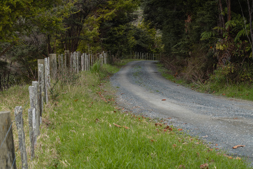
ABOVE: Smith Road in Matakana currently has a speed limit of 100km/h. Our assessment found this is not a safe and appropriate speed limit. The average speed vehicles travel at on this road is less than 30km/h. We propose changing the speed limit to 40km/h.
Narrow roads and no road markings
Narrow roads without any road markings require drivers to be more cautious which typically results in vehicles driving at slower speeds.
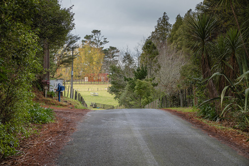
ABOVE: Welsh Hills Road in Swanson is narrow and does not have any road markings. We propose changing the speed limit from 80km/h to 60km/h.
No centreline
Road markings can significantly improve the safety of roads by giving drivers a better understanding of the road alignment. Centrelines, the lines which run down the centre of the road to divide oncoming traffic, are used where a road is greater than 5 metres wide. If a road is less than that, it does not have a centreline, but often has edge lines to show the road alignment. The lack of a centreline typically results in vehicles driving at a slower speed.
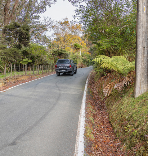
ABOVE: Mudgeways Road in Massey, which is narrow and does not have a centreline, currently has a speed limit of 100km/h. The average speed vehicles travel at on this road is currently 35-39km/h. We propose that a speed limit of 40km/h is safe and appropriate.
The number of twists and turns
Many of the roads we propose setting new safe and appropriate speed limits for are winding with lots of twists and turns for drivers to negotiate. Some roads have signage advising drivers of the speed they should travel the bend at (i.e. 25 km/h as pictured).
The twisting nature of these roads contributes to the current speed limits not being safe and appropriate.
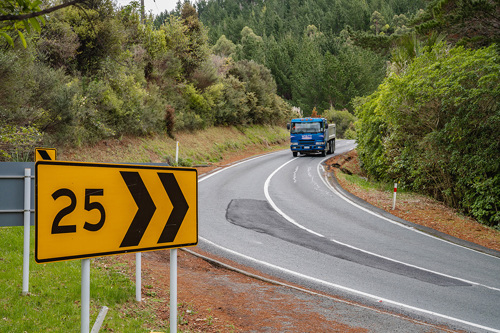
ABOVE: Matakana Valley Road in Matakana currently has a speed limit of 100km/h which our assessment has found is not safe and appropriate. We propose changing the speed limit to 80km/h and 60km/h on specified sections of the road.
Narrow roads with narrow shoulder widths
Narrow roads with narrow shoulder widths (the strip of road running along the outside of each lane) offer very little forgiveness if a driver makes a mistake when taking a corner.
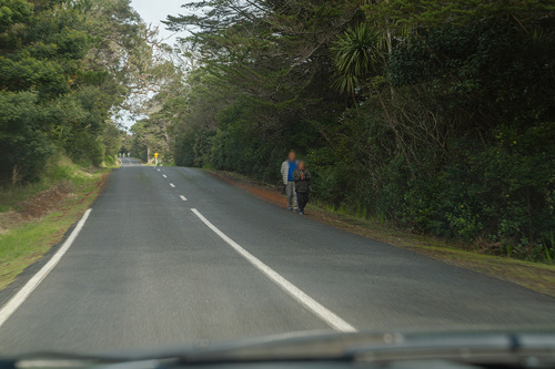
ABOVE: O’Neills Road in Swanson currently has speed limits of 100km/h and 70km/h. The average speed vehicles travel at is 45-54km/h. We propose changing the speed limits to 60km/h and 50km/h respectively.
Previous engagement about these roads
We previously sought community feedback concerning the speed limits on these roads back in 2018 as part of our Safe Speeds Accelerate Programme. We were exploring speed limit changes at that time however they were not progressed. From 9 November 2020 – 17 January 2021, we consulted on a fresh proposal to change speed limits on these roads following review under the Land Transport Rule: Setting of Speed Limits.
Safe speeds save lives
Auckland Transport is taking a Vision Zero approach to road safety. That means we are striving to have zero deaths or serious injuries on our transport system by 2050.
To achieve this, we are putting people first. Human life and safety come above all else. And, sometimes, that means our journeys might take a fraction longer. But, most of the time, the increase will only be a matter of seconds.
We understand that speed is also critical to the effectiveness and efficiency of our network. We are committed to ensuring the road network supports overall economic productivity. At the same time, we have a responsibility to ensure people and goods can move around the region safely, as well as efficiently.
Setting safe and appropriate speed limits is important because speed affects both the likelihood of a crash occurring and how badly someone gets hurt.
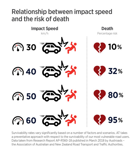
Public consultation
From 9 November 2020 – 17 January 2021, we sought public feedback on the proposed speed limit changes to 26 roads in Auckland’s west and north. In total 337 submissions were received. Thank you to everyone who took the time to provide feedback. You played an important role in shaping the future of our region and we appreciate it.
The feedback provided has been summarised and responded to in the:
How we're moving forward
After taking all of the feedback into consideration, the AT Board decided to approve the Speed Limits Amendment Bylaw 2021. This means we implemented the proposed speed limit changes above with the exception of the following alterations:
Road |
Original Proposal |
Decision |
|
Tram Valley Road Between Christian Road and 430m southwest of Christian Road (UTA boundary*) |
Increase speed limit from 50km/h to 60km/h
|
After considering new information related to subdivision activity happening on the land adjacent to the southern side of Tram Valley Road at its eastern end, we have changed our recommendation for this section to retaining the 50km/h speed limit rather than changing it to match the proposed rural 60km/h speed limit on the western part of Tram Valley Road. |
|
Whitmore Road Between 1,200m north of Bishop Lane and 1,200m north of Buckleton Road |
Increase speed limit from 50km/h to 60km/h between 1,200m north of Bishop Lane and 1,040m north of Buckleton Road
|
After considering consultation feedback and meeting with the Buckleton Beach Residents and Ratepayers Association, to improve speed limit signage visibility we have changed our recommendation for the speed limit boundary on Whitmore Road to be 1,200m north of Buckleton Road instead of 1,040m north of Buckleton Road (i.e. a change of 160m). |
|
Whitmore Road Between 1,200m north of Buckleton Road and Buckleton Road |
Reduce speed limit from 50km/h to 40km/h between 1,040m north of BuckletonRoad and Buckleton Road
|
After considering consultation feedback and meeting with the Buckleton Beach Residents and Ratepayers Association, to improve speed limit signage visibility we have changed our recommendation for the speed limit boundary on Whitmore Road to be 1,200m north of Buckleton Road instead of 1,040m north of Buckleton Road (i.e. a change of 160m). |
Click here to download the Speed Limits Amendment Bylaw 2021.
Once again, thank you for helping us make better decisions for your neighbourhood, informed by your local knowledge.
What happens next
The new safe and appropriate speed limits on these 26 roads in Auckland’s west and north came into force on 31 May 2021.