Routes 1 & 2: Surrey Crescent to Garnet Road & Richmond Road Routes 1 & 2: Surrey Crescent to Garnet Road & Richmond Road
Auckland Transport (AT) is in the process of reviewing feedback and making recommendations for design and consideration for further work to AT's senior management team.
Project status: On hold - pending outcome of the 2020 Emergency budget.
Project zone: Central
Project overview
We had proposed improvements in Grey Lynn and Westmere which involve creating protected cycleways, new pedestrian crossings, bus stops, raised speed tables at intersections to promote safety and changes to road markings.
These works are the continuation and improvement of the works that were halted in February 2018 on Surrey Crescent and Richmond Road.
Routes
The cycleways and associated improvements are being proposed across two routes:

Benefits
- Safer streets for everyone.
- Encourage more people to walk and cycle.
- Improved retail centres with better urban design.
- Fix the stormwater issues.
- Improve the locations of bus stops and pedestrian crossings.
- Add more trees and green space.
Background
As Auckland's population soars and traffic congestion gets worse, we need to find ways to make it easier and safer for people to walk and cycle. At the same time, we're also working to create a more 'forgiving' road network that recognises people sometimes make mistakes, but the consequences don’t have to be devastating.
This involves reducing vehicle speeds in residential areas and making streets safer for everyone - particularly vulnerable road users like children and people on bikes.
Learn more about the project history of Route 1: Surrey Crescent to Garnet Road and Route 2: Richmond Road.
Route 1: Surrey Crescent to Garnet Road
We are proposing for Route 1 - Surrey Crescent to Garnet Road:
- Raised tables at side streets and at pedestrian crossings to calm vehicle speeds.
- New pedestrian crossings.
- A mix of on-road cycleways and raised to level of footpath cycleway.
- A mix of bus stop layouts.
- A raised separator between parked cars and on-road cycleway.
- Significant planting to reflect history of place.
Typical cross section from Surrey Crescent to Garnet Road

Typical cross section in Old Mill village

Surrey Crescent and Richmond Road intersection
There are a large number of school children in the area and, at present, this intersection is very difficult to cross.
We propose installing some form of pedestrian crossing and other measures which will make it safer for people to cross here. We are currently investigating the best way to do that and would welcome your feedback on what you would like to see or the issues you currently face at this intersection.
Improved intersections
On each side street on both routes, we propose raised tables. A raised table is a raised section of the road, with ramps on each side, that aims to slow vehicles to a safe speed. These will also be used for pedestrian crossings to make it safer for people to cross.

Artist's impression of the Cumberland Avenue and Garnet Road intersection
Old Mill village
Proposed changes for Old Mill village:
- Quality materials and increased landscaping to promote a village feel.
- Keeping the existing Pohutakawa tree and adding other landscaping elements in the Old Mill traffic island to make it a better place to stay and enjoy.
- Providing a protected space for people on bikes and making it easier for pedestrians to cross the road.

Artist's impression of Old Mill village
Westmere School and Grey Lynn School
An overview of the proposed improvements outside Westmere School, similar changes are planned for outside Grey Lynn School:
- Creating an area where buses can park/children can get on and off buses safely.
- Cycleway outside the school is raised to the level of the footpath.
- Restricted parking zones at peak drop-off and pick-up times.

Artist's impression outside of Westmere School
Detailed plans for Route 1
Download the detailed design plans for route 1 to learn more about the proposed changes at specific locations (i.e. address or intersecting road).
Garnet Road
- 110 to 126 and 131 to 153 Garnet Road, includes Nottingham Street and Richard Street (PDF 4.43MB)
- 76 to 108 and 105 to 127 Garnet Road, includes Notley Street, Dorset Street and Cumberland Avenue (PDF 4.57MB)
- 52 to 78 and 83 to 103 Garnet Road, includes Westmere School, Warwick Avenue and Chester Avenue (PDF 4.63MB)
- 35 to 81 and 50 to 67 Garnet Road, includes Westmere School and Larchwood Avenue (PDF 4.40MB)
- 6 to 78 and 35 to 57 Garnet Road, includes Well Park Avenue, West View Road and Old Mill Road (PDF 4.56MB)
Old Mill Road
- 37 to 57 and 40 to 66 Old Mill Road, includes Francis Street and West View Road (PDF 4.33MB)
- 10 to 38 and 5 to 33 Old Mill Road (PDF 4.49MB)
Surrey Crescent
- 3 to 7, 53 to 69 and 156 to 184 Surrey Crescent, includes Sherwood Avenue and Bullock Track (PDF 4.33MB)
- 35 to 51 and 108 to 152 Surrey Crescent, includes Gilbert Avenue and Stanmore Road (PDF 4.38MB)
- 13 to 33 and 54 to 108 Surrey Crescent, includes Browning Street and St Columba Anglican Church (PDF 4.22MB)
- 1 to 13 and 44 to 54 Surrey Crescent, includes Firth Road, Selbourne Street and Grey Lynn School (PDF 4.45MB)
- 24 to 34 Surrey Crescent, includes Prime Road, Selbourne Street and Surrey Medical Centre (PDF 4.53MB)
Concept plans for Route 1
Download the detailed concept plans for Route 1 (PDF 1.34MB).
Route 2: Richmond Road
Careful consideration has been given to the proposed changes to Richmond Road and West Lynn village to ensure the character, history and charm of the village and streetscape is kept.
Proposed features include:
- Fixing the stormwater and ponding issues.
- Re-positioned and in-line bus stops.
- New and re-positioned pedestrian crossings - with better grades.
- Measures to slow vehicle speeds – like raised tables on all side streets.
- Safe, separated and connected cycleways.
- Enhance the sense of a green, vegetated streetscape.
Surrey Crescent to the village
We are proposing a cycleway on both sides of the road with raised tables at intersections.

Artist's impression of cycleway and raised table on Richmond Road.
Peel Street roundabout
We will finish what we started and make a better intersection for vehicles, pedestrians and people on bikes.
For more details, see concept plans for Route 2 (includes Peel Street roundabout).

West Lynn village
Concept plan for West Lynn village

For more details, see concept plans for Route 2 (includes West Lynn village).
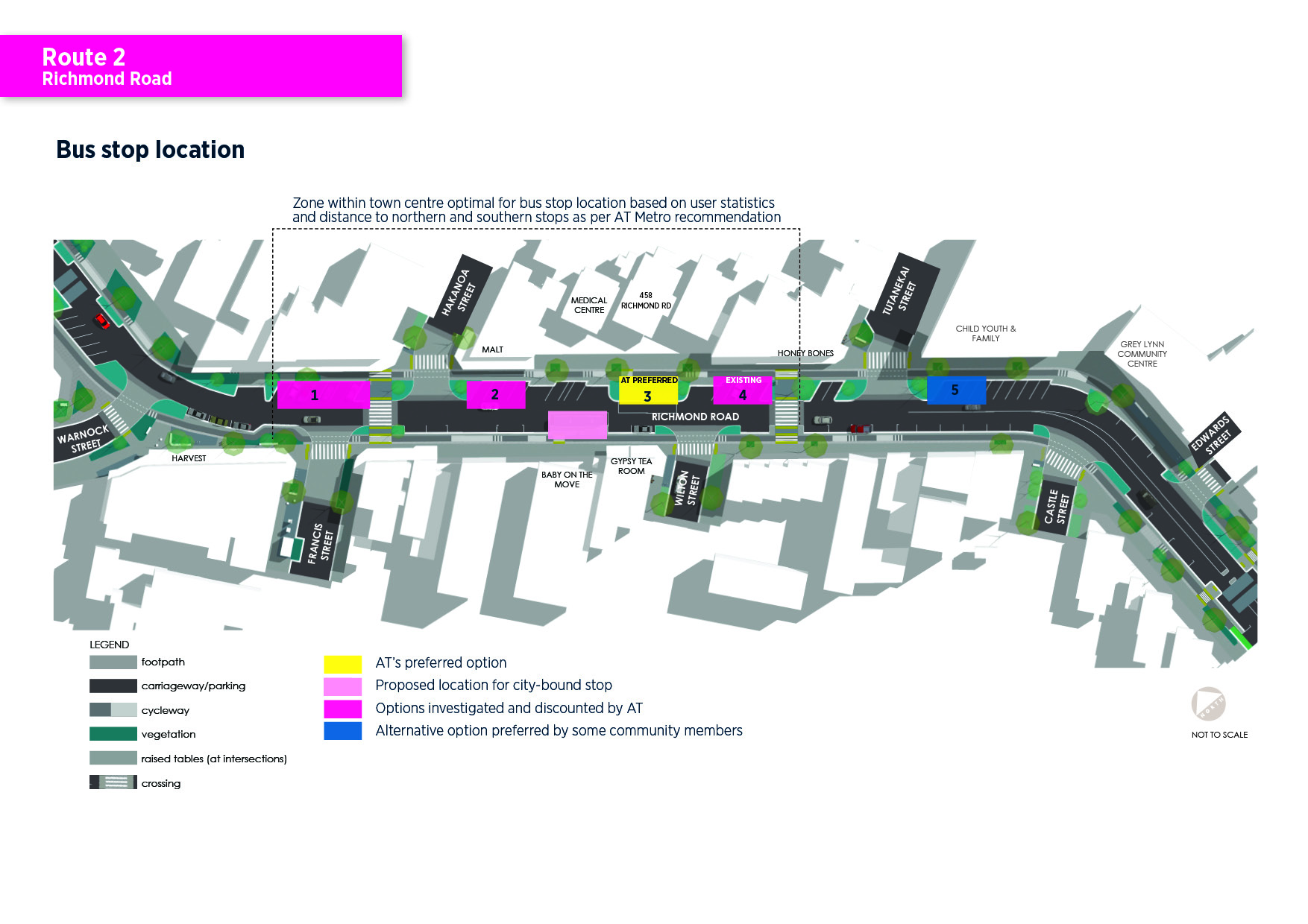
Proposed bus stop locations in the village

Artist's impression of bus stop locations in West Lynn village
Westmere-bound bus stop
We have heard that people are not in favour of the existing Westmere-bound bus stop in front of the liquor store. After considering bus user survey data, AT HOP card data and our urban design experts, we propose moving the Westmere-bound bus stop to 458 Richmond Road – opposite Gypsy Tea Room.
Reasons for this proposed location:
- The bus stop is centred within the village - statistics show a higher number of people use stops in the town centres.
- Good proximity to proposed city-bound stop (outside Baby on the Move).
- No conflict with existing retail frontages.
We've also heard people want it back to the original location outside of Child Youth and Family (CYFs).
City-bound bus stop
We propose moving the city-bound bus stop to go outside Baby on the Move at 449 Richmond Road. This will bring the stop closer to the one in the opposite direction and help to reduce blockages from cars parked illegally outside convenience retail reliant on short-term parking.
Investigated bus stop locations in the village
Four Westmere-bound bus stop locations were investigated in West Lynn village and some community members prefer a fifth location which is outside of Child Youth and Family (CYFs).

Download the map of bus stop locations in West Lynn village (JPG 1MB)
Option 1 - Opposite Francis Street entrance
| Advantages | Disadvantages |
|
|
Option 2 - Outside Malt
| Advantages | Disadvantages |
|
|
Option 3 - AT's preferred option
| Advantages | Disadvantages |
|
|
Option 4 - Exisiting location - stop moved to inline
| Advantages | Disadvantages |
|
|
Option 5 - Outside of Child Youth and Family (CYFs)
This is where the bus stop used to be prior to the changes that were made. It is outside of AT Metro's recommended zone for bus stop locations in town centres which is based on user statistics and the distance to northern and southern stops. However, we've heard that people want the bus stop to be located here again. We would like your views on the proposed bus stop location in the village.
Pedestrian crossing relocation in the village
To improve the alignment, visibility and safety of the cycleway, we propose moving the pedestrian crossing further up – between Francis Street and Hakanoa Street.
Reasons for this proposed location:
- Better visibility of the crossing for drivers coming from Ponsonby.
- Allows for a break in traffic for vehicles turning right into or from Francis and Hakanoa Streets.
- Crossing location works well with existing levels.
Detailed plans for Route 2
Download the detailed design plans for route 2 to learn more about the proposed changes at specific locations (i.e. address or intersecting road).
Richmond Road near Surrey Crescent
West Lynn village
- 476 to 534 and 475 to 513 Richmond Road, includes Grey Lynn Community Centre, Tutanekai Street, Baildon Road (PDF 4.46MB)
- 422 to 480 and 405 to 475 Richmond Road, includes Hakanoa Street, Francis Street, Wilton Street, Tutanekai Street (PDF 4.94MB)
- 388 to 436 and 351 to 409 Richmond Road, includes Warnock Street and Sackville Street (PDF 4.64MB)
Richmond Road near Hope Street
Countdown supermarket area
- 277 to 287 and 300 to 334 Richmond Road, includes Kingsley Street and Regina Street (PDF 4.33MB)
- 247 to 271 and 250 to 280 Richmond Road, includes Hukanui Reserve, Westmoreland Street West and Parawai Crescent (PDF 3.92MB)
Concept plans for Route 2
Download the detailed concept plans for Route 2 (PDF 1.28MB)
Construction timeline
We will be able to provide more precise information around construction timelines and impacts after we have processed your feedback and made the necessary changes. To build what is proposed will take over a year, however, please note, most residents will only see construction directly outside of their property for a few weeks.
Construction in the village centres will take longer, even if we are just addressing some of the existing concerns. We are very aware of the concerns of the businesses and residents about disruption during any construction. We are committed to keep listening and working with them to minimise any impacts going forward.
Construction work in the West Lynn village
We've been speaking with the business owners and we understand that minimising disruption is critical to them. We've been re-looking at our plans to see where we can reduce construction requirements. There are some issues that everyone agrees should be fixed, and getting that right will take a few months of construction.
Changes to parking spaces
In order to make these streets safer, more attractive and more accessible for everyone, some parking spaces will need to be removed. We will be able to provide information on the specific numbers at a later date. The project team is working on ways to maintain as much on-street parking as possible.
Public re-engagement
We sought feedback on the routes 1 and 2 proposals between 16 November and 14 December 2018 to help us improve and refine the proposal. Local knowledge gave us a better understanding of the area, the community's needs and any improvements that can be made to the design.
Download the Routes 1 and 2 brochure for Grey Lynn and Westmere (PDF 1.21MB)
AT values the feedback from those that participated. A total of 1084 individual submissions were received. These have been analysed by an independent company who have prepared a draft feedback summary report for AT.
Outcome
We have made it a priority to give all of the feedback due consideration because it is important to us that the consultation and design review processes are robust. We want to get this right and that’s meant taking the time to thoroughly review the design in conjunction with the feedback received.
We acknowledge that this process has taken longer than anticipated and we apologise for the delay.
Read the Public Feedback Report - Waitemata Safe Routes 17 July 2019 (PDF 4.6MB, 88 pages).
Next steps
AT will work closely with stakeholders on the design solutions. Once a final design is reached, we will notify submitters of the outcome and the construction timeline. We will be in touch later in the year.
As you may already be aware, there are some issues in West Lynn Village that need to be addressed regardless of the design outcome. One of the first areas to be addressed will be the footpath leading to the zebra crossing outside 428 Richmond Road to make it fully accessible for all users. We will also improve the footpath to the south-east of the crossing leading to Hakanoa Street to address the slope alongside the parking bays. In addition, these works will also address the issues with the drainage for the stormwater runoff from the footpath. This work will progress when the design and construction timeframes are agreed. AT is also mindful to avoid the busy November-December trading period.
We will notify those directly affected by these works in due course.