Point Chevalier to Westmere improvements (2017-2019) Point Chevalier to Westmere improvements (2017-2019)
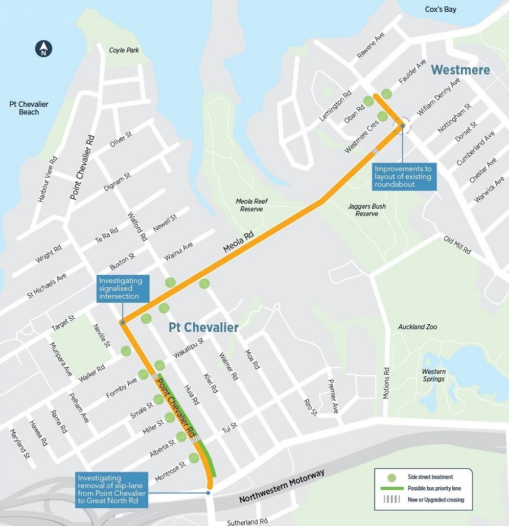
AT proposes making improvements to cycling and walking on Pt Chevalier and Meola Roads, from the Great North Road intersection, along Meola Road and Garnet Road, up to the Westmere shops.
Pt Chevalier cycleway update March 2018
After the public consultation for the Pt Chevalier cycleway that was held in April 2017, Auckland Transport took the community’s feedback into consideration. As a result, we decided to go back to the design and planning stage for the project.
Pt Chevalier residents were kept fully informed of the design process throughout the design and planning stage. Furthermore, there were a number of opportunities to feed into the decisions that needed to be made along the way.
The design and planning information in the 2016/2017 Cycleway Planning Process section of this webpage are associated with a previous consultation. They will remain on this page for reference purposes only.
Project status: Design.
Project zone: Central.
Route options
This project is looking toward the future and considering how Pt Chevalier will be in 20 years.
While there are many decisions that were made, it was determined that the best route for a cycleway is along Pt Chevalier and Meola Roads. Reasons for this route included:
- This was identified as the preferred route by the community.
- Links to the city cycle network. Future cycling projects will create safe connections to city via Great North, West End and Jervois Roads, and along the existing Northwestern cycleway.
- Connection to the Unitec development on Carrington Road.
- Better access between businesses, parks and reserves and other public amenities.
- Easy access to the cycleway for greater number of residents.
We considered other route options, such as along the ‘bird streets’ (Tui Street, Kiwi Road, etc.), however there are challenges having the cycleway in this area. Parking would need to be removed because of the road width to ensure safety levels are met, whereas Pt Chevalier Road is wide enough to accommodate the cycleway and on-street parking.
Options for Pt Chevalier Road
Based on community feedback, we investigated how a cycleway along Pt Chevalier Road could be constructed without removing the pohutukawa. The consultation also showed that people wanted to retain on-street parking outside the businesses. To meet the community’s aspirations, we realised a bidirectional cycleway along Pt Chevalier Road would create outcomes that would be untenable for businesses and residents. This option did not warrant further investigation.

Caption: An example of a single direction cycleway on Pt Chevalier Road with parking on the eastern side.
As such, a single directional cycleway was identified as the best option for Pt Chevalier Road. To create the space needed within the existing road corridor, AT is proposing to remove the median strip along Pt Chevalier Road. Removing the median strip will:
- create enough room for the cycleway to exist between the pohutukawa and footpath.
- retain parking on the eastern side of Pt Chevalier Road to enable access to the businesses.
- require the footpath width to be slightly narrowed in some areas. The footpath would remain the same width around shop canopies.
- allow for a bus lane to be installed at the Great North Road end of Pt Chevalier Road to improve transit times during evening peak.

Caption: An example of a single direction cycleway on Pt Chevalier Road, by Wakatipu Street and Formby Avenue, with parking on the eastern side.
Considerations for Meola Road
Our priority for Meola Road is to create a facility that enables cars, buses, people walking and people on bikes to travel safely along the road corridor. Our intention is to retain all of the existing trees where possible, and enhance the attractiveness of the area. To achieve these outcomes, the road area that is currently used for parking along Meola Road will need to be reprioritised to ensure the best use of that space, for the greatest number of people.
A survey of parking use along Meola Road showed that for 90% of the time there is very little demand. However, during events at Seddon Fields there is a short period of very high demand for parking. We will look to retain parking in the Seddon Fields area where possible, and we are working with stakeholders to investigate ways to meet the increased demand for parking during events.
Auckland Transport understands the importance of trees and the value residents place on them. We will in the first instance look to design around existing trees so they can be retained

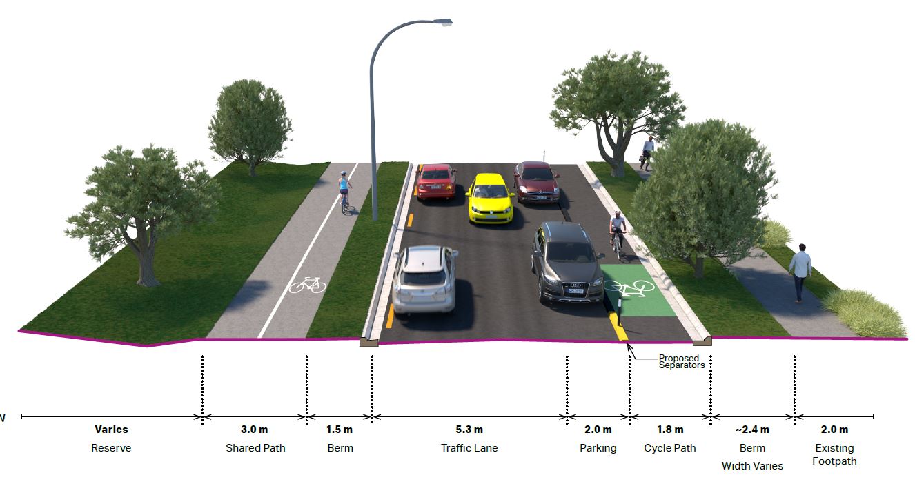
Caption: An example of a single direction cycleway on Meola Road by Walford Road.
Options for Meola Road
It is possible to build either a single direction cycleway or a bidirectional cycleway along Meola Road. No final decisions had been made on what this could look like and these will be presented to residents during the official consultation in 2019.

Caption: An example of a bidirectional cycleway on Meola Road by Walford Road.
Community Liaison Groups (CLG)
Auckland Transport established the Point Chevalier Streetscape and Cycleway CLG to provide a focus for two-way communication about the project, between Auckland Transport and Pt Chevalier residents, businesses and other key stakeholders. The CLG contributed to the project’s planning phase by:
- Ensuring that local organisations or groups with an interest in the project are involved in its development.
- Ensuring the project accurately reflects community aspirations and delivers established objectives and design principles.
- Identify and communicate community and stakeholder concerns about the project.
- Considering the range of community views, interests and issues related to the detailed design and construction of the project.
- Inter-organisation conversations.
The role of the CLG is consultative and the project team will carefully consider all input from the group in the light of overall strategic objectives for the project, as well as statutory and other government policy requirements.
- Download the CLG Terms of Reference (PDF 429KB).
- Download Meeting minutes for 30 May 2018 (PDF 319KB).
- Download Meeting minutes for 26 June 2018 (PDF 420KB).
- Download Meeting minutes for 31 July 2018 (PDF 292KB).
- Download Meeting minutes for 9 August 2018 (PDF 223KB).
- Download Meeting minutes for 27 November 2018 (PDF 104KB).
2016/2017 Cycleway Planning Process
Note: The design and plans for the cycleway that are on this webpage are associated with the 2017 consultation and remain on this webpage for reference purposes only. They are not associated with the 2018 planning and design process for a proposed cycleway in Pt Chevalier.
Project overview
The proposal includes both on-road and off-road cycling facilities and, in some locations, improved pedestrian crossings and intersections.
Key features of the project include:
- Safe cycling facilities for Pt Chevalier Road, Meola Road and Garnet Road, physically separated from traffic where possible.
- Layout changes to key intersections (Pt Chevalier Road and Meola Road, Meola Road and Garnet Road) to improve safety and better manage traffic.
- Improvements to side road intersections to slow traffic, improve visibility and create a safer road environment for all users.
- A new pedestrian crossing on Pt Chevalier Road near the Formby Avenue and Wakatipu Street intersection.
- Improvements to the existing pedestrian crossing on Pt Chevalier Road north of Tui Street intersection.
- A pedestrian refuge on Meola Road upgraded to a zebra crossing.
We are investigating the feasibility of a peak hour south-bound priority lane (bus/T2/T3) for Pt Chevalier Road, from Great North Road to Wakatipu Street, to improve the public transport commute during evening peak times. If this goes ahead, the bus lane would only operate during evening peak time, and parking would be permitted in this space at all times. If it does not go ahead, on-street parking will be permitted at all times.
There is limited space available along this route to share between traffic, parking, pedestrians, cyclists and public transport. To create space we propose to relocate some roadside features (such as street lighting, trees and other services), remove some on-street parking and change the layout of some key intersections.
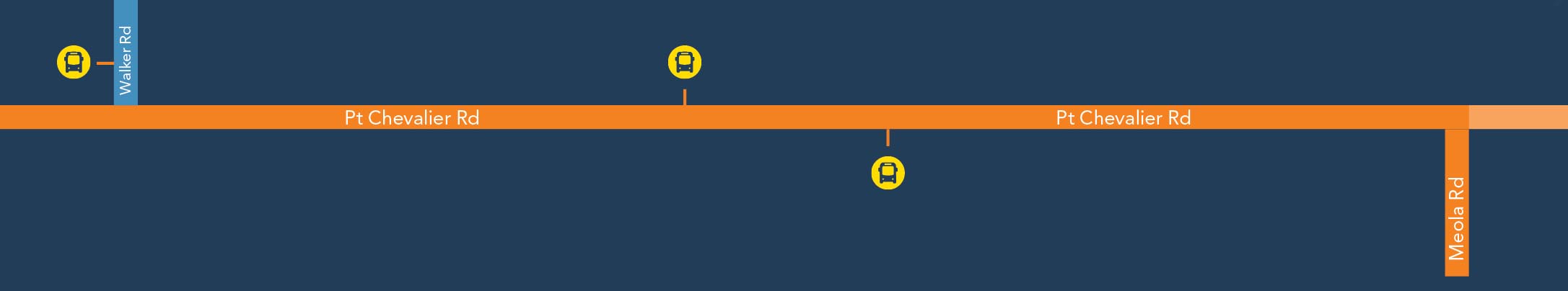
Route map
Proposed design plans
View and download proposed design plans for the entire route (PDF 4.5MB)
Pt Chevalier Road (from Great North Road to west of Wakatipu Street)

For this section, we are proposing an on-road cycle lane in both directions, with physical separators between the cycle and traffic lanes, and additional side road treatments to increase safety for all users.
Some trees will need to be relocated. On-street parking will be removed along the west side and there will be additional side road treatments to increase safety.
A small section of the central median will be retained by Tui street, to provide a waiting space for turning vehicles. The rest of the central media will be removed.
We are investigating a possible peak priority bus lane on the eastern side, to improve the public transport commute during evening peak times. If this goes ahead, the bus lane would only operate during evening peak times and parking would be permitted during other times. If this does not go ahead parking would be allowed at all times.
The existing zebra crossing between Tui Street and Alberta Street will be upgraded to a new signalised crossing.

Pt Chevalier Road (from Wakatipu Street to before Walker Road)

For this section, we propose an on-road, dedicated cycle lane that will run in each direction, separated from traffic by a physical buffer. Additional side road improvements will increase safety for all users.
Some trees along this section will be relocated, and the central median will be removed to make room for the proposed cycle lanes.
Parking will remain on the east side of the road, and removed on the west side of the road.
A new zebra crossing will be installed north of the Wakatipu Street intersection.

Pt Chevalier Road (from Walker Road to Meola Road, including Meola Road / Pt Chevalier intersection)
For this section, we propose an on-road, dedicated cycle lane that will run in each direction, separated from traffic by a physical buffer. Additional side road improvements will increase safety for all road users.
We are proposing to install traffic signals at the Pt Chevalier / Meola Road intersection. The design of this intersection upgrade is yet to be finalised, but we are investigating designs that will provide a high level of safety for pedestrians and cyclists.
Some trees along this section will need to be relocated, and parking will be removed on both sides of the road to ensure that the central median has enough space for high volumes of right-turning traffic.

Meola Road (from Pt Chevalier Road to before Meola Park) - residential section

For this section, we are proposing an on-road cycle lane in each direction, separated from traffic by a physical buffer and additional side road improvements to increase safety for all road users.
Given the limited space of this section of the road, we propose to remove parking on both side to make room for the new cycle lanes. We are investigating the potential to add indented bays in the berm where possible.
The road will be widened on the northern side to accomodate the new cycling facilities. Services (including street lighting) will be relocated as required. We do not expect to remove or relocate any trees along this section of road.
This project coincides with planned maintenance works on Meola Road, meaning minimal disruption for residents and road users.

Meola Road (from Meola Park, including existing Meola Road bridge, to after Seddon Fields) - reserve section
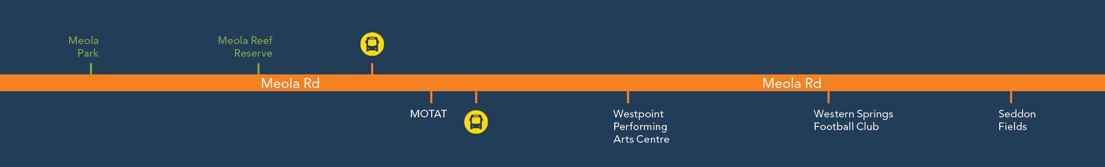
For this section, we are proposing a new shared path for the northern side, with painted separation between pedestrians and cyclists. Currently, there is no footpath on this side of the road.
The southern side will mostly consist of an on-road cycle lane, protected from traffic by physical barriers. There will be a short section of shared path between the entrance to the Seddon Fields car parks after the Meola Road Bridge.
The on-street parking on the northern side of the road will be removed to make room for the proposed cycle facilities. Parking on the southern side will remain, outside the new protected cycle lane.
The existing footpath on both sides of Meola Road Bridge will be widened to accommodate the 3 meter shared path.
As part of the road upgrade we need to widen the road by moving the northern kerb in some sections. Services (including street lighting) will be relocated as necessary. We do not expect to remove or relocate any trees along this section of the road.
This project coincides with planned maintenance works on Meola Road, meaning minimal disruption for residents and road users.
Meola Road (from after Seddon Fields to Garnet Road) - residential section

For this section, we are proposing an on-road cycle lane in each direction, separated from traffic by a physical barrier where possible.
We propose to upgrade the pedestrian refuge opposite 21 Meola Road to a zebra crossing.
The on-street parking on both sides of the road will need to be removed.

Garnet Road (from Meola Road roundabout to Westmere shops)

For this section, we are proposing protected cycle lanes on both sides of the road, separated from traffic by a combination of physical barriers and parked cars.
We will aim to keep as much on-street parking as possible, but the new layout may result in some parking removal for safety reasons.
The Meola Road and Garnet Road roundabout layout will be changed to a single-lane roundabout, with side street improvements on Westmere Crescent to increase safety for road users.

Improvements to Pt Chevalier Road and Meola Road intersection
We are proposing to install traffic signals at the Pt Chevalier and Meola Road intersection. The design of this intersection upgrade has not been finalised, but we are investigating designs that will maximise safety for pedestrians and cyclists.
Adding traffic signals will better manage traffic flow, and protect cyclists turning in to or our of Meola Road. The pedestrian crossing will offer cyclists an alternative to cycling with the traffic, and will improve pedestrian safety.

Meola Road roundabout
The Meola Road and Garnet Road will be changed to a single-lane roundabout. The design of this intersection upgrade has not been finalised, but we are investigating designs that will maximise safety for pedestrians and cyclists. Street lighting at the roundabout will also be improved.

Side roads
At several T-junctions on side roads along the route we propose to install raised speed tables to improve safety for pedestrians and cyclists.
These speed tables will slow traffic down, making drivers more aware of other road users walking or cycling in the area.
Raised speed tables are proposed for the intersection of:
- Pt Chevalier Road and Montrose Street.
- Pt Chevalier Road and Alberta Street.
- Pt Chevalier Road and Miller Street.
- Pt Chevalier Road and Smale Street.
- Pt Chevalier Road and Formby Avenue.
- Pt Chevalier Road and Wakatipu Street.
- Pt Chevalier Road and Walker Street.
- Meola Road and Huia Road.
- Meola Road and Kiwi Road.
- Meola Road and Walford Road.
- Meola Road and Moa Road.
- Garnet Road and Westmere Crescent.
- Garnet Road and Faulder Avenue.
- Garnet Road and Oban Road.

On-street parking
To accommodate the new cycling, walking and bus changes, we propose changes to on-street parking arrangement along this route.
We understand the importance of on-street parking to residents and local businesses and have taken care to minimise the loss of any parking from these streets.
Where possible, we have relocated bus stops and reconfigured the existing parking to retain as much on-street parking as possible
Public engagement
Feedback on this proposal was open from 27 March to 23 April 2017. We received a total of 1221 public submissions.
We have produced 2 feedback reports: the first gives an overview of the feedback and the second summarises specific design suggestions and our response to them.
Key feedback themes
These themes were identified in over 20% of submissions:
- 56% of submitters like the proposal overall (688 submissions).
- 39% are concerned about Meola Road parking loss or suggested alternative parking options in the area (478).
- 37% want or support walking and cycling improvements generally (457).
- 28% dislike proposal overall (341).
- 25% are concerned about Meola Road width, congestion or safety (312).
Design suggestions
Submitters suggested a wide range of design changes to the proposal. The second feedback report collates these and our response to them.
We received a number of design suggestions relating to specific locations along the route and we will consider these as we move into the detailed design phase of the project. With no significant changes identified, the design plans we consulted on remain unchanged at this stage, but refinements will be made during the detailed design phase.
Feedback reports
- Download the summary of feedback - Part 1: Key themes (PDF 1.3MB, 39 pages)
- Download the summary of feedback - Part 2: Design suggestions (PDF 392KB, 33 pages)
Next steps
We are now beginning work on the detailed design phase, which involves investigating and finalising all aspects of the design. We will continue to work with key stakeholders to refine the proposed designs and incorporate suggestions raised during consultation where possible.
As decisions are made and designs progress, we will publish updates and make new plans available prior to construction.
We expect construction to begin in early 2018, and be completed by mid-2019.
Previous feedback
In March 2016, we sought feedback on potential cycle routes between Pt Chevalier and the city fringe (bounded by the Northwestern motorway and the sea).
The feedback we received was mostly supportive of our proposed cycle network and identified a wide range of issues and concerns that put them off cycling. Where possible we have aimed to address these issues when planning the proposed routes.
Find out more about the Pt Chevalier to city fringe proposal and feedback.