Porters Avenue level crossing Porters Avenue level crossing
The orignal City Rail Link design included bridging Porters Ave over the rail link. Since then a number of changes to the project have meant that we are revisiting this design.
Project status: Investigation
Project zone: Central
Project overview
Changes to the Porters Ave level crossing will be made as part of the City Rail Link construction near Mt Eden Station, expected to start in 2018. The CRL will join Auckland’s rail network from Waitematā Station (Britomart) to Mt Eden Station, adjacent to Porters Avenue/Wynyard Road.
The concept design for the CRL in 2013 included bridging Porters Avenue over the rail link. Since then, a number of changes in the project have required AT to propose alternative designs for the Porters Ave level crossing.
Feedback on the proposed options for the Porters Avenue level crossing was open from 4 to 14 March 2016.
We will share outcomes of the consultation once we have finished analysis and investigation.
Project details
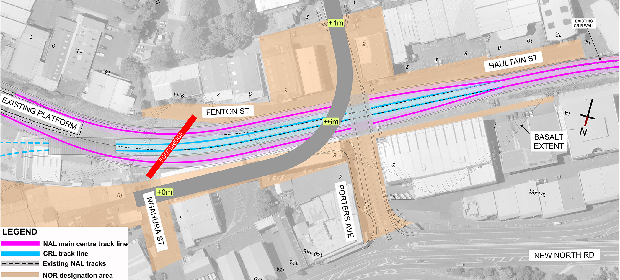
The orignal design for the Porters Ave level crossing
The original CRL designation concept design for Porters Ave level crossing proposed:
- A grade-separated road crossing of the North Auckland Line (NAL) at Porters Ave.
- The road would pass over the rail corridor on a bridge with the NAL and CRL tracks lowered in a cutting.
- The cutting would extend through the existing Mt Eden Station area, and the design assumed a flat junction between the east and west facing rail connections north of Mt Eden.

This concept design is no longer possible because:
- Removing Newton Station from the CRL has allowed a grade separation of the rail tracks. This ensures a safer and more efficient rail network and means the track no longer needs to be in a deep cutting at Porters Ave.
- It would require a much higher road bridge with a difference of 2-3m in the road levels at the connection of Porters Ave and New North Road.
Download the map showing the CRL and North Auckland Line alignment and track levels (JPG 1.38MB)
Options for Porters Ave level crossing
Alternative design options for Porters Ave have been developed, and assessed on these criteria:
Strategic
- Development and regeneration potential.
- Third party impacts – consenting, acquisition of land, etc.
Traffic
- Delays to transport movements caused by barrier gate closures.
- Rail travel times by removing speed restrictions caused by level crossings.
- Risk of rail network disruption caused by the interface between level crossings and rail signalling.
- Rail network disruption due to a level crossing incident.
- Potential impacts on the operation of emergency services.
- Impacts of travel times to vehicle traffic.
- Risk of death and injury caused by collisions at level crossings.
- Impact on pedestrian and cyclist connections and access.
- Accessibility to socially important community facilities.
- Wider road safety impacts.
FInd out about traffic impacts analysis that informed the option assessment.
Environmental and social
- Potential visual impact of surface structures (e.g. bridges) on underlying residential zones and on other activities sensitive to visual impact.
- Potential operational noise and vibration impacts and effects on any sensitive receivers.
- Potential impacts on major stormwater/networks services and utilities.
- Private land take.
- Impacts on businesses/shops.
- Construction duration impact to local stakeholders (and effects on construction).
Economic
- Construction cost difference between options.
- On-going maintenance and operational cost of the option.
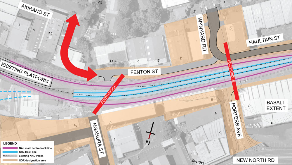
Option C1 - the best performing option
- Close Porters Avenue level crossing.
- Install pedestrian/cycle bridges from Fenton to Ngahura Streets, and Wynyard Road to Porters Ave, providing access to and from New North Road.
- Vehicles to use alternative routes.
Impact:
- Continues to provide pedestrian and cyclist connectivity to the south-west and, with potential for redevelopment in the New North / Dominion Rd junction area, demand for this route may increase in the future.
- Least visual and construction impacts.
- No additional land take, and most cost-effective to build and maintain.

| Totals | 12:07 |
| Assessment criteria | Score |
|---|---|
| Strategic | 2:50 |
| Traffic | 2:50 |
| Environmental and social | 3:57 |
| Economic | 3:50 |
Option C2
- Close Porters Ave level crossing.
- Install pedestrian/cycle bridges from Fenton to Ngahura Streets, and Wynyard Road to Porters Ave, providing access to and from New North Road.
- Connect the road at the eastern end of Fenton to Akiraho Streets.
Impact:
- Requires purchasing land outside the CRL designation and new consents with negative impacts on the construction programme.
- Would reduce the rail corridor to accommodate the road alignment between Fenton St and Akiraho Streets.
- Increased vehicle movements near an existing childcare centre in Akiraho St.
| Assessment categories | Score |
|---|---|
| Strategic | 2:00 |
| Traffic | 2:59 |
| Environmental and social | 3:07 |
| Economic | 3:75 |
| Totals | 11.41 |
Option C3 - the worst performing option
- Construct a 6m high, 120m long bridge over the North Auckland Line, connecting Ngahura Street to Wynyard Road.
- Install a pedestrian/cycle bridge from Fenton to Ngahura Streets.
Impact:
- Significant negative social impact as it would require the demolition of the Ngahura Street apartments (48 households).
- Visual impact of a 6m high and 120m long bridge.
| Assessment category | Score |
|---|---|
| Strategic | 2:00 |
| Traffic | 3:09 |
| Environmental and social | 2:50 |
| Economic | 2:25 |
| Totals | 9:84 |
Traffic impacts analysis
Impacts of closing Porters Ave
Flow Transportation Specialists carried out traffic counts to understand how traffic currently uses Porters Ave. It assessed what the traffic effects would be of closing the road by analysing this data. It concluded that the local road network could support the change in traffic movements if Porters Ave is closed without noticeable changes in traffic congestion. The effects were:
- Walking and cycling trips would not be affected.
- There would be no use of Porters Ave by through traffic.
- Traffic volumes on Porters Avenue and Wynyard Road would generally reduce.
- Existing vehicle trips across the level crossing would redistribute to alternative routes:
- to the east, via View Road, Esplanade Road and Mt Eden Road.
- to the west, via Brentwood Avenue or View Road, Dominion Road, George or Tawari Streets, and New North Road.
- The above alternative routes will generally be longer than existing routes. For some trips, this increase may be as much as 1.4km; for most trips, the increase will be less.
- Some travel times will not change noticeably, but other trips may take 2 to 3 minutes longer.
- There may be small increases in traffic at the intersections of the above streets.
- Closure of the level crossing would reduce traffic at the New North Road/Porters Ave intersection.
- Approximately 50 vehicles per hour less in each direction on New North Road.
- Approximately 100 vehicles per hour more in each direction on Mt Eden Road.
Traffic movements on Porters Ave
Flow assessed current vehicle movements across the Porters Ave level crossing as modest. There were 1450 northbound (Wynyard towards New North Road) vehicles surveyed and 1400 southbound (New North Road towards Wynyard Road). The vehicles were 1 per cent heavy commercial and 99 per cent cars, vans and utility vehicles. For comparison, Dominion Road has 26,000 and Mt Eden Road 15,000 vehicles per day.
Traffic currently using the level crossing is generally accessing local properties however, anecdotally, it is used by both through traffic and ‘park and ride’ traffic.
Table: Surveyed vehicles across the Porters Ave level crossing (number of movements per hour).
| Mode | Direction | Morning peak | Inter peak | Evening peak |
|---|---|---|---|---|
| General traffic | Northbound | 130 | 90 | 145 |
| Southbound | 155 | 85 | 125 | |
| Pedestrians | Northbound | 68 | 47 | 17 |
| Southbound | 15 | 46 | 48 | |
| Cyclists | Northbound | 5 | 0 | 4 |
| Southbound | 4 | 0 | 4 |
Traffic safety
 Flow also assessed the crash history at affected intersections, to identify safety impacts if Porters Ave is closed. It concluded that net safety would be improved due to reduced traffic at the problematic New North Road/Porters Ave intersection. The intersection impacts were:
1. New North Road/Porters Ave intersection
A poor crash record. Closure of the level crossing would reduce traffic through the intersection, improving road safety.
2. New North Road/George Street intersection
A typical crash record for an intersection of its type. Increased right turns from George Street may increase the crash exposure.
3. Dominion Road and Charles Street/Tawari Street/Horopito Street intersections
This section of Dominion Road has a relatively high crash record, but without any trends in crash type. Increased right turns at these intersections may increase the crash exposure.
Most traffic may prefer to use View Road over Horopito Street however, as this signalised intersection offers a safer opportunity to turn right onto Dominion Road.
4. View Road/Wynyard Road intersection
A low reported crash history.
5. View Road/Esplanade Road intersection
A moderate crash record. Increased traffic may increase the crash exposure.
6. Esplanade Road/Mt Eden Road intersection
A high crash record, mostly relating to right turns out of Esplanade Road. Closing the level crossing is not expected to increase right turns out of this street however.