Manurewa (Area 2) safety improvements Manurewa (Area 2) safety improvements
Area 2 is bound by Mahia Road, Great South Road, and Weymouth Road.
Auckland Transport (AT) are making safety improvements on residential streets in Manurewa (Area 2) to provide a safer environment for all road users. Construction to begin in early January 2022.
- Public engagement for road safety improvements in Manurewa (Area 2)
- Read the feedback report
- Consultation decisions and recommendations
Project status: Construction
Project zone: South
Project overview
Manurewa (Area 2) Road Safety Improvement is the second area-wide speed calming project in Manurewa.
We aim to reduce vehicle speeds by installing a combination of speed-calming measures such as speed humps, raised tables, roundabouts and zebra crossings where justified.
The improvements are for the area contained by Mahia Road, Great South Road and Weymouth Road, as shown on the map below.
Find out how we will make our streets safer with our Residential Speed Management programme.
These improvements are part of AT's commitment to reducing the number of deaths and serious injuries on our roads by 60% over the next 10 years.
This project is partly funded by the Regional Fuel Tax and supported by the Manurewa Local Board.
Construction
Following consultation in March 2021, Auckland Transport has engaged Fulton Hogan and Ventia to install speed-calming measures in Manurewa, starting January 2022.
What you need to know
- Starts January 2022 and will take approximately 6 months to complete - dependent on weather and COVID-19 restrictions
- Work will be done in stages and multiple roads may be worked on at the same time
- Day work hours are from 7am-7pm. If night work is needed on your road, you will be notified
- You will receive a letter in the mail notifying you of roadworks on your road prior to construction
- Some temporary parking restrictions will apply - cones and no parking signs will be used to limit parking when needed
- Help keep our construction crew safe by slowing down around work sites, follow signage and be ready to stop
Access to your home
- You may experience detours and delays while work is taking place
- Driveway access may be restricted at times. You will be notified if driveway access is restricted for longer periods
- Traffic controllers will be onsite to assist drivers and people walking. Pedestrian access will be maintained
Construction programme for 2022
| Month (2022) | Main affected street (Contractor: Fulton Hogan) |
| January |
Dr Pickering Ave, McDivitt St/Mahia Rd, Sykes Rd, Glenveagh Park Dr, Castlefinn Dr, Coxhead Rd |
| February | Coxhead Rd, Morrin St, Kirton Cr, Thompson TCE, Mountfort St, Claymore St, William Ave |
| March | Eddowes St, Ruby St, Friedlanders Rd |
| April | Schedule to be confirmed |
| May | Schedule to be confirmed |
| June | Schedule to be confirmed |
| Month (2022) | Main affected street (Contractor: Ventia) |
| January | Beaumonts Way, Blossom Lane, Christmas Rd, Puriri Rd, Rogers Rd, Beaumonts Way Extension |
| February | Blossom Lane, Christmas Rd, Puriri Rd, Rogers Rd, Beaumonts Way Extension, Churchill Ave, Totara Rd |
| March | Puriri Rd, Rogers Rd, Beaumonts Way Extension, Churchill Ave, Totara Rd |
| April | Puriri Rd, Rogers Rd, Churchill Ave, Rimu Rd, Bowater Place, Buller Cres/Kita Rd, Kohiwi Rd, Tawa Cres |
| May | Puriri Rd, Rogers Rd, Churchill Ave, Rimu Rd, Bowater Place, Buller Cres/Kita Rd, Kohiwi Rd, Tawa Cres |
| June | Bowater Place, Buller Cres/Kita Rd |
Updated map for construction

Contact us
For information about construction or work sites, please contact:
Fulton Hogan – orange shaded area on map above (west of and including Coxhead Road)
- Jessica Mani - jessica.mani@fultonhogan.com 0800 947 007
Ventia – green shaded area on map above (east of and excluding Coxhead Road)
- Tracey Bouwer - tracey.bouwer@ventia.com 0800 877 8725
For all other queries contact:
Auckland Transport - projects@at.govt.nz 09 3553 553
What we identified in Manurewa (Area 2)
We have identified various areas for road safety improvements. Manurewa (Area 2) has been prioritised based on these factors:
- Safety concerns raised by residents
- Local Crash Analysis System (CAS) data – 131 crashes in the last five years. A crash map for the area can be found here (PDF 459KB)
- Vehicle speeds on key roads in Manurewa (Area 2) are in excess of the current speed limits
- The three highest speeds recorded were in excess of 121km/h on Rimu Road, McDivitt Street and Coxhead Road
- Location of community facilities (schools, shops, parks and community centres).
The speed calming measures chosen for the area will help to create a slower speed environment, which is safer for everyone. This will help to reduce the risks of accidents, serious injuries and death as well as make the streets safer for pedestrians, encouraging people to walk and cycle more.
Download the Manurewa (Area 2) road safety improvements brochure. (PDF 6.18MB)
Road safety improvements
The project aims to reduce vehicle speeds on local residential streets in Manurewa (Area 2) we are planning on installing a combination of speed calming measures including:
- raised table zebra crossings
- raised Swedish-style speed tables
- standard raised tables
- speed humps
- entry treatment in the form of red-coloured surfacing.
Learn more about speed calming measures and their benefits.
The improvements will require the removal of 8 to 10 car parks where zebra crossings and raised tables are being installed, and the movement of some bus stops and intersections, for safety and visibility reasons.
Our transportation engineers have selected the type and location of each proposed safety measure based on a variety of criteria. These include:
- Proximity to schools or other locations where there are a higher number of people walking or on bikes.
- International best practice guidelines for positioning measures to reduce speed in residential areas.
- Space available between driveways and/or bus stops.
- Whether roads are bus routes.
Public engagement
We consulted on this proposal from 11 February to 31 March 2021 to improve our plan for these road safety improvements. Your local knowledge has given us a better understanding of the area and your needs and has helped us improve the design.
We asked whether you:
- have any thoughts on the proposed road safety improvements.
- have any suggested changes to the proposed road safety improvements.
- have any other comments or suggestions to improve road safety in this area of Manurewa.
Feedback
You can read the community feedback results report here. (PDF 534KB)
You can find the original proposal overview map here. (PDF 390KB)
Consultation decisions and recommendations
We received feedback from the general public and key interest groups. We have made changes to the proposal in response to the feedback received.
The overall summary of changes:
- We removed a total of 28 speed humps
- We replaced 18 speed humps with 9 roundabouts
- We replaced 10 speed humps on Coxhead Road with speed cushions
Below is an overview map of the updated proposal and an accompanying table of specific locations and changes.
Updated map following consultation
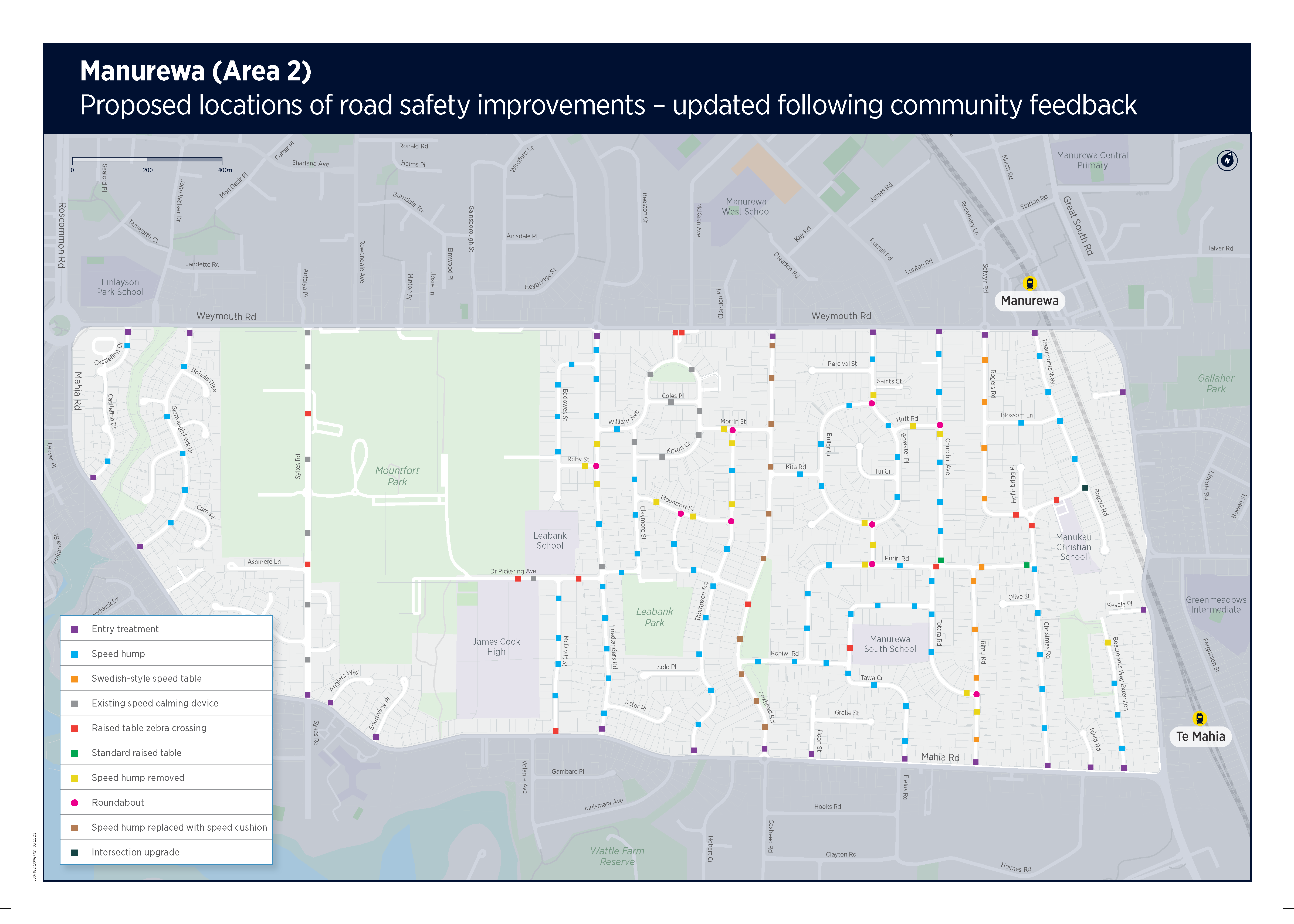
Download the updated overview map. (PDF 410MB)
Table of specific locations and changes
| Location | Design Change | |
| Proposed | Result of feedback | |
| Coxhead Road - between Mahia and Weymouth Road | 10 speed humps (The raised table zebra crossing to the south of O'Connell Street remains) |
10 speed cushions |
| Friedlanders Road / Ruby Street intersection | 3 speed humps | 1 roundabout |
| Thompson Terrace / Morrin Street intersection | 2 speed humps | 1 roundabout |
| Thompson Terrace / Mountfort Street intersection | 1 speed hump | 1 roundabout |
| Mountfort Street / O'Connell Street intersection | 2 speed humps | 1 roundabout |
| Bowater Place / Buller Crescent intersection (north) | 1 speed hump | 1 roundabout |
| Bowater Place / Buller Crescent intersection (south) | 2 speed humps | 1 roundabout |
| Bowater Place / Puriri Road intersection | 1 speed hump | 1 roundabout |
| Churchill Avenue / Hutt Road intersection | 2 speed humps | 1 roundabout |
| Rimu Road / Totara Road intersection | 1 speed hump and 1 speed table | 1 roudnabout and the relocation of 1 Swedish-style table |
| Rogers Road / Beaumonts Way intersection | 1 speed hump | Side islands and splitter island |
| Beaumonts Way Extension (northern end) | 1 speed hump | - |
Other roads will have speed calming measures as proposed in the consultation.
| Location | Advance Notice of Upcoming Additions |
| Friedlanders Road | The feedback presented an opportunity to establish 4 new school bus stops on Friedlanders Road. A seperate targeted consultation with directly impacted residents is planned. |
The locations of speed calming improvements for your street for both the original and updated proposal are shown in detailed plans in the table below:
Road names in italics are roads with no changes proposed.
| Road name | Original Drawing | Updated Drawing |
| Beaumonts Way | Drawing set 1 (PDF 24MB, 15 pages) | Updated Drawing Set 1 (PDF 19.8MB, 12 pages) |
| Blossom Lane | ||
| Christmas Road | ||
| Beaumonts Way extension | ||
| Hollingrigg Place | ||
| Olive Street | ||
| Rogers Road | Drawing set 2 (PDF 27MB, 16 pages) | Updated Drawing Set 2 (PDF 27.2MB, 16 pages) |
| Churchill Avenue | ||
| Hutt Road | ||
| Totara Road | ||
| Rimu Road | ||
| Bowater Place | Drawing set 3 (PDF 37MB, 22 pages) | Updated Drawing Set 3 (PDF 36.7MB, 22 pages) |
| Saints Court | ||
| Percival Street | ||
| Buller Crescent | ||
| Tui Crescent | ||
| Kita Road | ||
| Albertson Place | ||
| Puriri Road | ||
| Kohiwi Road | ||
| Tawa Crescent | ||
| Coxhead Road | Drawing set 4 (PDF 37MB, 22 pages) | Updated Drawing Set 4 (PDF 37.2MB, 22 pages) |
| Thompson Terrace | ||
| Morrin Street | ||
| Claymore Street | ||
| O'connell Street | ||
| Mountfort Street | ||
| Solo Place | ||
| William Avenue | ||
| Kirton Crescent | ||
| Coles Place | ||
| Friedlanders Road | Drawing set 5 (22MB, 13 pages) | Updated Drawing Set 5 (PDF 23.1MB 14 pages) |
| Eddowes Street | ||
| Dr Pickering Avenue | ||
| Astor Place | ||
| Mcdivitt Street | ||
| Sykes Road | Drawing set 6 (PDF 29.8MB, 19 pages) | Updated Drawing Set 6 (PDF 27.1MB, 19 pages) |
| Ashmere Lane | ||
| Celmisia Place | ||
| Bernina Place | ||
| Zurich Place | ||
| Rhine Place | ||
| Senecio Place | ||
| Anglers Way | ||
| Glenveagh Park Drive | ||
| Bohola Rise | ||
| Belleek Close | ||
| Derryveagh Lane | ||
| Carn Place | ||
| Loughinisland Place | ||
| Castlefinn Drive | ||
| Woodside Road | ||
| Kevale Place | ||
| Nield Road | ||
| Boon Street | ||
| Grebe Road | ||
| Southview Place |
Next steps
Construction is planned to commence January 2022 (dependant on weather Auckland’s COVID alert levels). We will be in touch with local residents and business prior to any construction taking place.
Monitoring surveys are planned for 2022 to understand effects and public perceptions of the improvement measures.