Waitakere Ranges urban design guidelines Waitakere Ranges urban design guidelines
The Waitākere Ranges is an area of national, regional and local significance. Auckland Transport (AT) recognises this and has produced a guide to the principles and practices of road corridor design and management in the Waitākere Ranges Heritage Area (WRHA).
The guide establishes a set of principles that acknowledges the specific character of the area, assists in meeting the requirements of the Waitākere Ranges Heritage Area Act (2008), and still delivers routes and connections that are safe and convenient for all road users.
Public engagement
Feedback on the Waitākere Ranges Heritage Area urban design guidelines closed on 17 November 2015.
AT received a substantial amount of feedback and the design guide was well supported on the whole. We received a variety of feedback from the local community, including the Waitākere Ranges Local Board, Residents and Ratepayer’s groups from Piha, Laingholm, Waiatarua and Parau, the Waitākere Ranges Protection Society, and Bike Auckland.
Next steps
The project team will be meeting with the local board in February 2016 to discuss the consultation feedback and possible changes to the design guide. The final urban design guidelines will be published on the website as part of the AT Code of Practice (ATCOP).
Waitākere Ranges Heritage Area design guidelines
Background
To provide guidance on principles and practices of road corridor design and management which assist in meeting the requirements of the Waitākere Ranges Heritage Area Act, 2008 (the Act).
Terms of reference
The Road Corridor Design and Management Guide covers all works (including routine and emergency maintenance and repairs and upgrades) which have the potential to adversely affect the Act’s objectives or could help to implement them, for example by restoration or enhancement of landscape character. This includes footpaths, kerb and channel and other stormwater management structures, retaining walls/structures, signage, safety/crash barriers and traffic-calming measures. It does not include vegetation management.
Introduction
Auckland Transport (AT) recognises the national significance of the Waitākere Ranges Heritage Area (WRHA) and has produced this guide to support the existing AT Urban Design Principles and AT Code of Practice to bring forward outcomes that are appropriate to this important location.
The guide establishes a set of principles which recognise the specific character of the WRHA while still delivering routes and connections that are convenient and safe for all users.
The Waitākere Ranges Heritage Area Act recognises that an important feature of the heritage area is the subservience of the built environment to the area’s natural and rural landscape. However, ‘The Waitākere Ranges Heritage Area Monitoring Report (2013)’ (the monitoring report) highlighted the impact that urban style road corridor design was having on the landscape of the heritage area and recommended the design specifications for infrastructure in the road corridor in the heritage area be reconsidered.
This guide discusses how to ensure that this is achieved to ensure:
- All outcomes are appropriate to this significant location.
- The built environment remains subservient to the natural and rural landscape.
The Waitākere Ranges Heritage Area
The national, regional and local significance of the Waitākere Ranges Heritage Area has been recognised by the Waitākere Ranges Heritage Area Act 2008, which seeks to promote the protection and enhancement of the heritage features of the area for present and future generations.
The Heritage features include:
- The terrestrial and aquatic ecosystems of prominent indigenous character.
- The different classes of natural landforms and landscapes.
- The coastal areas.
- The natural functioning streams of the eastern foothills.
- The quietness and darkness of the Waitākere Ranges and coastal parts of the area.
- The visual backdrop to the Auckland Metropolitan Area.
- The Heritage Area’s wilderness experience and recreational opportunities.
- The eastern foothills.
Get further details in the Auckland Council guide to the heritage features (PDF 357KB)
The Act requires that effect must be given to its purpose and the relevant objectives when preparing or reviewing a district plan, regional policy statement or regional plan that affects the heritage area or when considering an application for resource consent for a discretionary or non-complying activity in the heritage area.
While not explicit in the legislation, AT consider that it is also appropriate to ensure that within the Heritage Area the Codes of Practice are interpreted in a way that brings forward outcomes that sit comfortably within the character of the area.
Waitākere Ranges Heritage Area Act 2008, Section 8: Heritage Area Objectives
The objectives of establishing and maintaining the heritage area are:
- to protect, restore, and enhance the area and its heritage features;
- to ensure that impacts on the area as a whole are considered when decisions are made affecting any part of it;
- to adopt the following approach when considering decisions that threaten serious or irreversible damage to a heritage feature;
- carefully consider the risks and uncertainties associated with any particular course of action; and
- take into account the best information available; and
- endeavour to protect the heritage feature.
- to recognise and avoid adverse potential, or adverse cumulative, effects of activities on the area’s environment (including its amenity) or its heritage features:
- to recognise that, in protecting the heritage features, the area has little capacity to absorb further subdivision:
- to ensure that any subdivision or development in the area, of itself or in respect of its cumulative effect,-
- is of an appropriate character, scale, and intensity; and
- does not adversely affect the heritage features; and
- does not contribute to urban sprawl:
- to maintain the quality and diversity of landscapes in the area by:
- protecting landscapes of local, regional, or national significance; and
- restoring and enhancing degraded landscapes; and
- managing change within a landscape in an integrated way, including managing change in a rural landscape to retain a rural character.
- to manage aquatic and terrestrial ecosystems in the area to protect and enhance indigenous habitat values, landscape values, and amenity values;
- to recognise that people live and work in the area in distinct communities, and to enable those people to provide for their social, economic, environmental, and cultural well-being;
- to provide for future uses of rural land in order to retain a rural character in the area;
- to protect those features of the area that relate to its water catchment and supply functions;
- to protect in perpetuity the natural and historic resources of the Waitākere Ranges Regional Park for their intrinsic worth and for the benefit, use, and enjoyment of the people and communities of the Auckland region and New Zealand.
AT's principles for the Waitākere Ranges Heritage Area
In line with the findings of the monitoring report, AT recognises that incremental minor alterations to roads, footpaths, signage and other features within AT's control can cumulatively lead to changes to the character of the area. Careful consideration of these matters can result in positive change that benefits the overall character of the WRHA.
In order to ensure that future changes are sympathetic to the area, AT has developed a set of principles which together will ensure that the scenic, sightseeing and landscape character of the heritage area, the rural character of the bush, individual identity and character of the villages and low key and understated appearance of the low-density residential development will remain dominant.
Principle 1: In each case to carefully consider whether ‘improvements’ are required
Principle 2: The installation of standard urban infrastructure will not be seen as the norm
Principle 3: Maintain the overall informal character of the road corridors both within villages and the wider WRHA.
Principle 4: Ensure that traffic speeds are slowed to be appropriate to the rural area
Principle 5: Where possible utilise local materials which sit comfortably within the area
Principle 6: Ensure that projects consider the character and ecology of the landscape adjacent to the road
Principle 7: Signs, lines and street furniture are kept to the minimum needed for safety and intrusive roadside clutter is removed.
Principle 8: Where signs and markings are needed, adapt standard designs or develop new to make them the best possible fit with local surroundings.
Principle 9: Encourage and test innovative approaches and make full use of the flexibility in national regulations, standards and codes of practice to bring forward outcomes that are appropriate to the area.
Principle 10: For significant projects bring together a multidisciplinary team that is able to to ensure that the outcome shows a good appreciation of all matters that contribute to the overall character of the area as well as providing a good technical outcome.
Design guidelines
Whether ‘improvements’ are required
AT recognises that incremental minor alterations within the WRHA can cumulatively lead to changes to the character of the area. At the inception of any project very careful consideration will be given as to why the potential works are required. This will include consideration of:
- Whether the works are necessary for road safety
- Whether the works could have a positive, neutral or negative impact upon the WRHA.
Safety and speed management
Ensuring that traffic travels at an appropriate, slow speed within the WRHA, both within the rural area and within villages, has a very significant impact upon people’s enjoyment of the area.
Slower speeds will enable residents and visitors to appreciate the characteristics of the nationally important landscapes from the road and also allow different users, including walkers, cyclists and pedestrians, to share the road.
- Within the rural area, natural calming measures should be considered as a means to passively slow traffic speeds rather than urban, built interventions.
- This can include visually narrowing the carriageway with additional planting within berm areas.
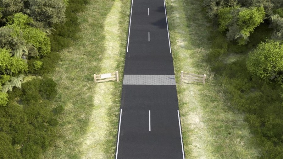
- Marking the entrance or ‘gateway’ into villages and settlements signals to the driver that they are entering a different environment and should alter their driving pattern.
- This can be marked by built elements such as timber fences.
- Signs can be incorporated into these features.
- Changes in road surface can also mark these thresholds and be used in other locations to passively slow traffic.
- This may include the utilisation of cobble stones or small unit setts that create noise and vibration for drivers as well as visually marking entrances. The impact of these upon the amenity enjoyed by adjacent land uses must be considered as part of the decision.
- An effective alternative to the use of cobbles or setts is the use of a section of concrete with appropriate local aggregate rolled into the surface or other textured surface.
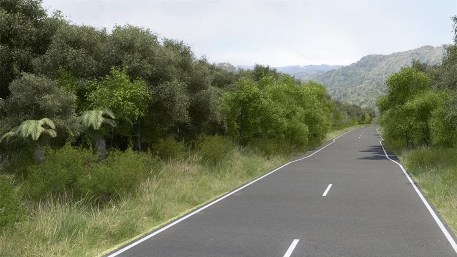
- The retention of an unformed edge to the road with swales is more in character with the informal character of the villages and rural sections of the WRHA and could also encourage slower speeds than a more formalised kerb and channel arrangement.
Landscape
The design and upgrade of roads and footpaths should not be considered in isolation. It is important that they sit unselfconsciously within their surroundings and respect the character and heritage of the landscape adjacent to the road. It is also important that the works do not have a negative environmental impact upon their surroundings and consideration should therefore be given to their ecological impact; further consideration is given to the specific issue of storm water below.
- All development will, where practicable, use local natural materials or materials to reflect the materials of the locality of the development.
- Where possible, existing swales should be retained and not replaced with kerb and channel.
- Consideration will be given to utilising gravel for footpaths where circumstances permit; however the decision whether to use gravel will take into account the level of service expected and the expected maintenance required.
- Where concrete is used for footpaths it should be tinted with black oxide. While this will fade over time, it will provide the opportunity for the surface to weather naturally over time.
- Where areas of concrete tinted with black oxide are repaired, the repair will be similarly tinted to provide the best possible colour match. However, it is recognised that it is not practical to expect to fully colour match repairs and they may remain visible for many years.
Road design
It is important that the roads retain their informal, rural appearance. However, there is often a difficult balance between providing for the needs of all of the main users, pedestrians, cyclists and cars, with the need to retain a low key, ‘low engineered’ appearance.
- Roads should generally be designed to least possible width to cater for the needs of their users.
- Where space permits, footpaths should generally be separated from the main carriageway.
- The needs of cyclists will be considered on a case by case basis. The different opportunities, constraints and circumstances in each area means that a bespoke response may be needed rather than relying on usual standards.
- While it generates greater noise, the use of course chip seal should be seen as the norm within the WRHA. It has a less urban appearance than other options and is more in keeping with the overall character of the area.
- The greater noise generated by course seal is also likely to passively calm the traffic
- The use of High Friction Surfaces is also acceptable, although care should be taken to ensure that the aggregates selected are of appropriate colours for their specific location.
- Consideration should be given to the use of alternative surfaces where surrounding uses are sensitive to the noise generated
- Road edges should be informal in character with swales preferred to kerbs and channels in both villages and rural area. This is more in keeping with the overall character of the WRHA.
- Exceptions to this includes central Titirangi and instances where the topography, volume and speed of runoff or the needs of pedestrians means that swales are impractical or will not function effectively.
- Unless there are overriding health or road safety reasons, existing unsealed roads should remain unsealed.
- Where there are good reasons, which may include: addressing environmental impacts, reducing maintenance or addressing accessibility issues, to seal a previously metaled road careful attentions should be paid to the design of the altered road to ensure that it remains as informal as possible.
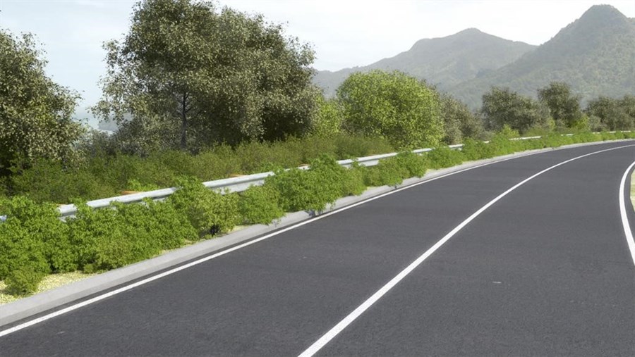
- AT recognises that crash barriers have an urban appearance. However, the topography of the WRHA and the design of roads through the area means that they are sometimes necessary. To ensure that they function as required it is likely that they will have to be of a standard design.
- Where possible, the crash barrier will be set behind/within existing roadside vegetation to minimise its visual impact.
- Wire rope barriers, with posts retained in a galvanised finish which will dull over time and not stand out excessively against surrounding vegetation is the preferred option as this will be visually less obtrusive. However, these are only suitable where there is an appropriate deflection zone. Where this zone is not available W-shape barriers may be utilised.
- Where W-shape barrier is required the retention of existing plants to the front and behind is very important as it is not realistic for the barrier to be painted due to the ongoing maintenance required.
- Where practicable, the installation of a safety barrier should not be accompanied by the installation of kerb and channel as this would further urbanise the area.
- It is recognised that a kerb and channel may be required to ensure water does not damage any retaining wall associated with a barrier. If this is the case their overall length will be kept to a minimum.
- Where retaining walls are required, they should be faced in natural materials that are in sympathy with the surrounding area.
- Steps, terraces and associated landscape planting should be utilised to reduce the overall height and dominance of the retaining walls.
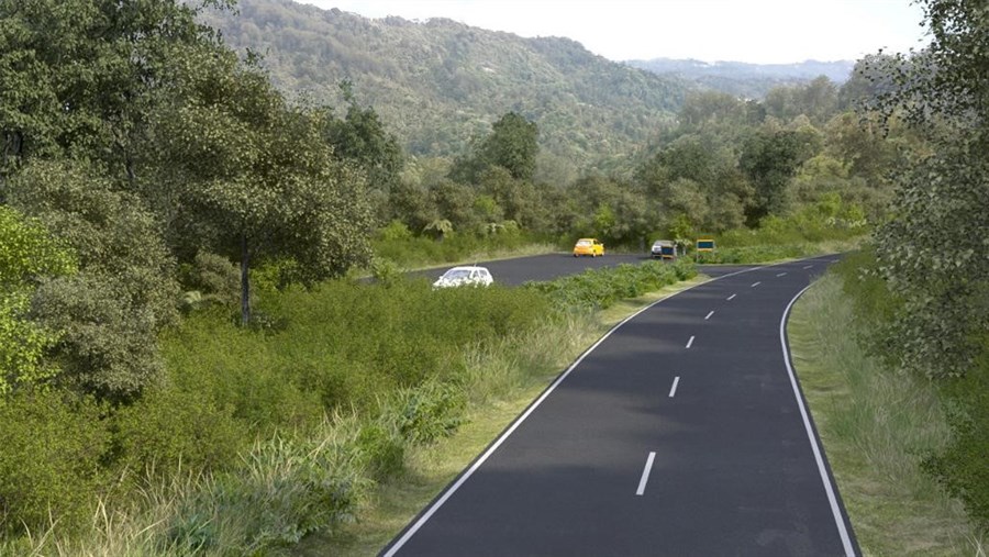
- The design of roadside parking and layby areas should follow the general advice of this guide.
- They should be very informal in appearance and where possible have a metalled rather than sealed surface.
- Entrances to roadside parking areas that are separated from the road should be kept narrow to ensure that they do not become over dominant.
- Natural calming and other passive calming measures should be utilised within the vicinity of parking areas to reduce vehicle speeds and improve overall safety.
Signs and road markings
- Experience shows that reducing road signs and markings to the minimum can passively calm traffic by encouraging drivers to better interact with their environment and to drive more appropriately. Too many signs also create clutter and can impact on views within the area; together these detract from the overall amenity of the WRHA.
- Utilising standard designs for road signs or excessive use of painted road markings are likely to undermine the natural values of the WRHA.
- Where new signs are required, AT will therefore bring forward signs of a design that recognise the informal and rural character of the area.
- AT will consider the overall existing provision of road signage within the WRHA and look towards reducing the number of poles and signs where feasible
- This may include utilising a pole for more than one existing sign so reducing the current number of poles
- AT will work with the Local Board to bring forward a new design of road sign for use solely within the WRHA. This will utilise materials for the pole which are sensitive to the rural character of the area and will carefully consider the appropriate reflectiveness and colour of the signage.
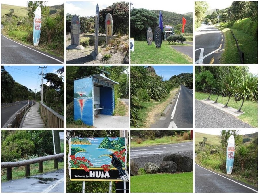
- Within individual communities, AT will consider the incorporation of community-led art elements into some of the infrastructure, including signage to ensure that the new infrastructure contributes to the character and identity of the area. Existing examples include the ‘Free Range Kids’ surf board at Bethells Beach.
- Changes in road surface will be considered as an alternative to markings painted on roads as they can equally indicate to drivers that they are approaching hazards or other features.
Storm water
Runoff from roads can have a detrimental impact upon surrounding habitats. However, the creation of kerbs and channels to manage storm water runoff can also have an impact upon the overall character of the WRHA as they are of an overall urban appearance.
Where practical, swales should be utilised to provide some retention and cleaning of the stormwater from roads, footpaths and cycle ways prior to it being discharged onto surrounding land or where appropriate entering a reticulated system.
Lighting
By its very character, the WRHA is generally not an area where high levels of lighting are expected and the Act specifically identifies the heritage significance of the ‘darkness’ of the area. AT recognises that it is therefore necessary to balance the lighting levels against the overall character of the area and that lighting (quietness and darkness) is a specific focus of the area.
- Careful consideration should be given to the appropriate level of lighting within a particular area. This will require a careful and controlled balance between the environment and safety requirements.
- AT will consider the removal of existing lighting if this represents an enhancement of the heritage character of the area, providing that there would be no adverse safety effect.
- All road lighting should be designed to zero spill light. Where this cannot be achieved spill light must be limited to the absolute minimum.
- Lights should be further adjusted by use of the tele-management system to reduce light levels at times of low road use.
Footpaths
There are no dedicated footpaths alongside the road in many parts of the WRHA, this places pedestrians in the vulnerable position of having to walk along the carriageway. There are two possible alternatives; to provide a dedicated footpath or to reduce vehicle speeds sufficiently that it is safe for pedestrians to walk on the road.
Vehicle speeds on open roads within the WRHA can be high. Where it is not possible to reduce these speeds to a safe level, it is desirable to separate pedestrian footpaths from the main carriageway. However, the undesirability of kerbs and channels, or other physical barriers which have an urban appearance, may mean that there needs to be greater physical distance between users than would be the norm. Where new footpaths are proposed there may be the need to extend the width of the road reserve to accommodate the footpath behind a swale and/or berm.
- Alternatively, consideration can be given to providing even greater separation by taking a footpath through an adjacent reserve or open space.
- Within villages pedestrians are often forced to walk on the road. Consideration will be given to new footpaths, walkable berms or cycling routes that local communities have identified that they would like to see developed as a priority. The available road reserve and ability to form a separate footpath within these areas is often limited. Where this is the case AT will look at ways to reduce overall vehicle speeds to improve pedestrian safety.
Street furniture and structures
The utilisation of standard designs and styles of street furniture and structures could lead to the urbanisation of the character of the WRHA. AT will therefore look towards utilising street furniture that has been designed specifically for use within the WRHA; for instance timber bollards instead of metal bollards. AT would also like to incorporate community-led art elements. Existing examples include the Ark in the Park bus shelter on Te Henga Road.
- Street furniture and structures should reflect the overall low key appearance of the area. They should incorporate local and natural materials. Wherever possible, consideration will be given to working with local designers to help ensure that new street furniture and structures contribute to the character and identity of the area.
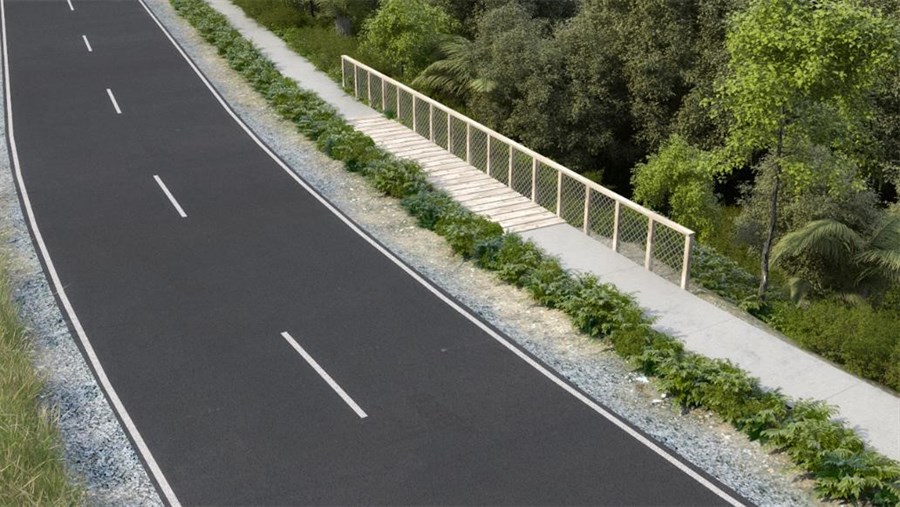
- Bridges and other structures should be low key in appearance and not appear overly engineered; for instance simple rural style fencing with chainlink fencing between could be an alternative to more formal balustrading.
Vegetation management
AT recognises that the road network is an intrinsic and valuable element of any area’s character and that the way in which the roads and roadside environment are managed can have a significant effect on local distinctiveness, character, heritage and biodiversity.
It is very important to AT that weeds and pest plants within the road reserve are actively managed to ensure that there is no negative impact upon the local ecology. In the Waitākere Ranges Heritage Area, it is AT's expectation that the highest standards of management will be applied.
AT seeks to protect and, where practicable, restore and enhance native vegetation and habitat for native species within road corridors in the WRHA.
Specific guidance regarding vegetation management within the WRHA is given in AT's Vegetation in the Road Corridor Guidelines. Find out more:
- Auckland Council Weed Management Policy.
- AT Code of Practice (see Chapter 14. Landscaping).
Print the guideline document
Download the Draft Waitākere Ranges Heritage Area urban design guidelines (PDF 604KB).