Eastern Busway Te Arapahi o te Rāwhiti
The Eastern Busway is a fast, reliable and safe busway connecting Botany to Pakūranga and to the rail service in Panmure.
On this page
Project details
Start date
2018End date
2027Location
PakūrangaTransport involved
Walking, driving, bus and cyclingOverview
The Eastern Busway is a key part of Auckland’s rapid transit network, connecting East Auckland to the wider region.
When City Rail Link opens in 2026, people will be able to use the already open section of the busway from Pakūranga to catch a quick bus and a direct train to Eden Park, New Lynn and Henderson.
When the full busway to Botany opens in 2027, Auckland Transport’s connected network will make it easy to get from east to west Auckland without driving.
As well as connecting surrounding suburbs with the rail network, the Eastern Busway makes local trips easier by providing more options for walking and biking.
Latest updates
Cost savings and additional funding will allow the final stretch of the Eastern Busway to be built, enabling buses to directly connect to Botany Town Centre on a corridor separate to other traffic.
The final section of busway to be built from Tī Rākau Drive through Guys Reserve Whakamaumahara was previously unfunded, with a plan to provide an interim bus route in general traffic for the final section where Tī Rākau Drive meets Botany Town Centre.
NZ Transport Agency Waka Kotahi (NZTA) and Auckland Council have confirmed $101 million in funding to enable construction of the Botany link route at Guys Reserve.
Significant overall programme savings and efficient delivery have helped contribute towards the funding.
AT’s Eastern Busway Alliance will start construction in March 2026.
Rā Hihi is a critical part of the Eastern Busway project. Providing a direct link between Pakūranga Highway and Pakūranga Road, the flyover eases congestion around Pakūranga town centre and improves travel times while allowing construction of the busway beneath it to continue at pace. Rā Hihi (meaning sun's rays) crosses Tī Rākau Drive so drivers bypass one of the busiest intersections in New Zealand. It has 4 vehicle lanes — 2 in each direction.
The flyover is 600 metres long and 18 metres wide. It has 17 sections (spans) that are supported by 16 piers. The longest span reaches 40 metres over Tī Rākau Drive.
It opened 5 months ahead of schedule and came in $4 million under budget while remaining in scope. Time and cost savings came from multiple approaches. The biggest time saver was using cranes to move the temporary bridge support. Instead of assembling and then dismantling the supports, cranes were used to lift and shift them into place. This reduced the time needed for each bridge section from 8 to 10 days per span to just 2 to 3 days.
Smart technology was also used during construction. Wireless concrete sensors were used during concrete pours to check temperature and strength gain. The devices sent back data, in real time, which let the team know when the concrete was dry. This saved one month in total.


Work at Panmure Station transformed the area into a modern public transport interchange, improving connections between bus and rail services.
The station upgrade boosted public transport patronage by 275% over three years and has reduced travel times. With buses now running every 5–10 minutes on congestion-free lanes, it is now up to 17 minutes faster to get to Waitematā Station from Botany using public transport and 8 minutes faster from Pakūranga.
The improvements also include new cycle lanes, pedestrian paths, and better access to surrounding areas, supporting more sustainable travel choice and making active transport safer and more accessible.


Timeline
Construction of the busway from Pakūranga to Botany
This section of the Eastern Busway is being built by an alliance of Auckland Transport with Fletcher Construction, ACCIONA, AECOM and Jacobs, in partnership with mana whenua.
The project includes 12km of walking and cycleways, 7km of busway and 5 new stations. It will deliver wide-ranging benefits — increasing access to jobs and education and attracting investment and growth.
Mokoia heritage reserve and mahi toi installation
Mokoia heritage reserve will be created in partnership with mana whenua as part of the Eastern Busway project.
This welcoming space will honour local heritage and enhance the natural environment, offering a peaceful area for the community to enjoy for generations.
Project designs
About the Eastern Busway
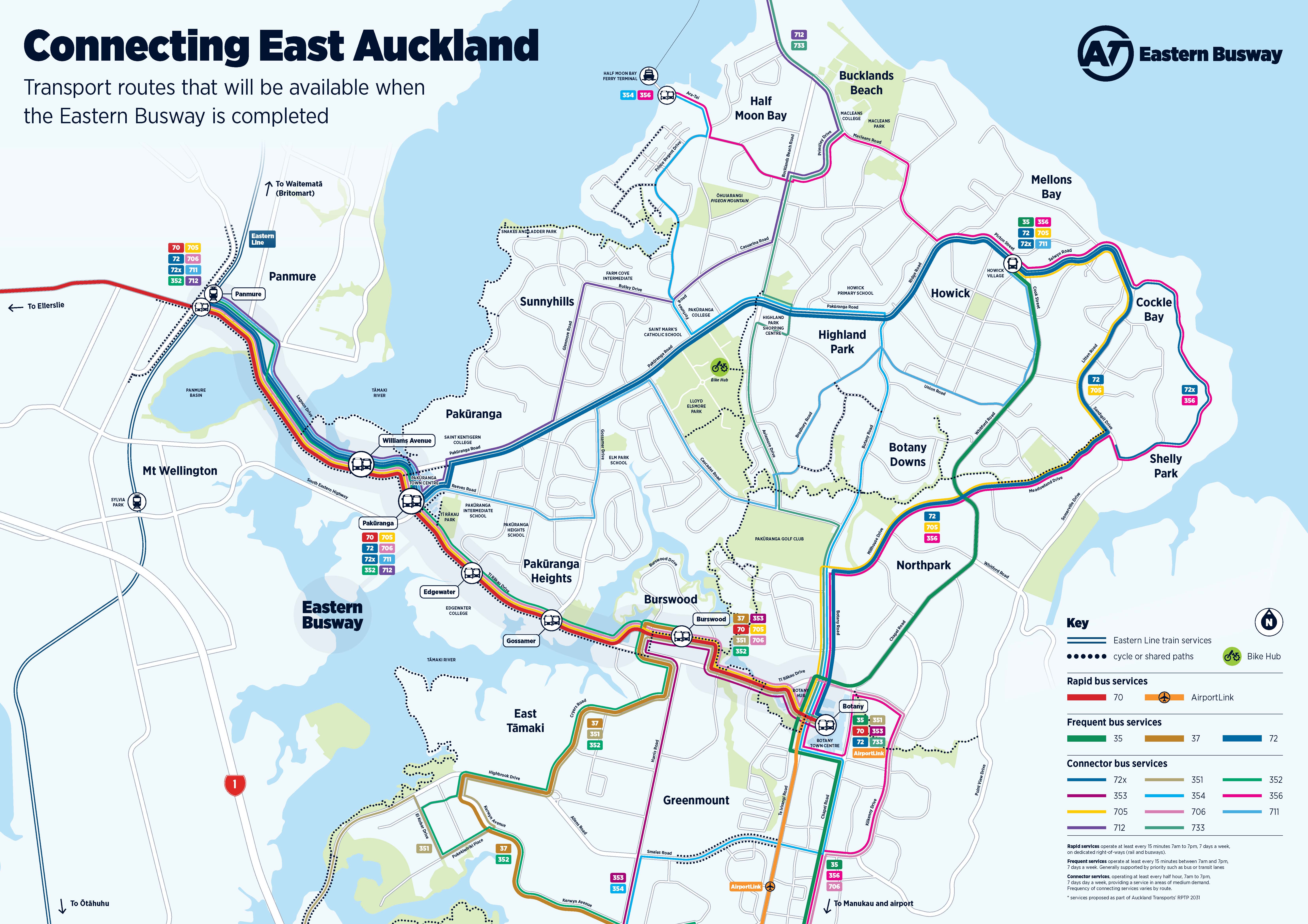
Eastern Busway features map
Project benefits

Faster, more reliable travel

Better public transport connections

Improved safety and accessibility
