Route 3: Greenways Route Route 3: Greenways Route
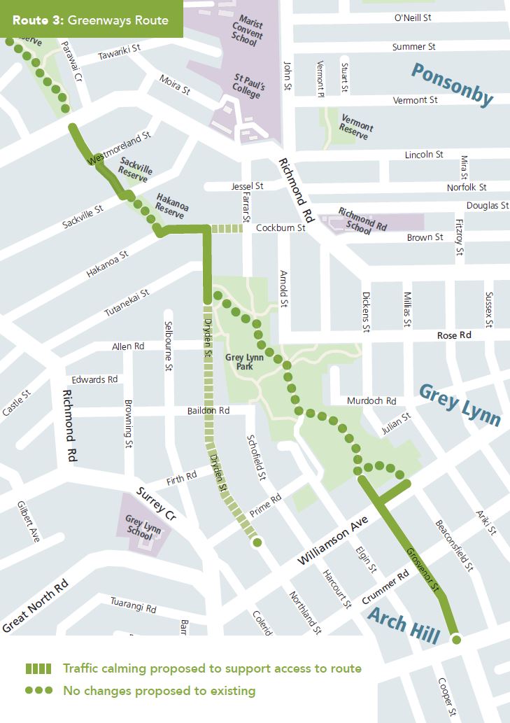
This greenways route connects existing facilities in Cox’s Bay Reserve to Great North Road, via Westmoreland Street, Hakanoa Reserve, Cockburn Street, Dryden Street, Grey Lynn Park, and Grosvenor Street.
We have completed construction of the improvements.
Key features
- A new signalised pedestrian crossing on Richmond Road (east of Westmoreland Street).
- Footpath widening along Westmoreland Street to create a 3m-wide shared walking and cycling path.
- A widened alley between Westmoreland Street West and Sackville Street to 3 metres, and removal of the high timber fence along the western side of the alley.
- Raised tables and speed humps along the route and some surrounding streets (Westmoreland Street, Sackville Street, Hakanoa Street, Cockburn Street, Dryden Street, Grosvenor Street).
- New roundabouts with pedestrian crossing refuges, at 2 locations: intersections of Dryden Street and Allen Road, and of Grosvenor Street and Crummer Road.
- A new signalised midblock pedestrian crossing slightly east of the intersection of Williamson Avenue and Grosvenor Street.
- An upgrade of the northern footpath on Williamson Avenue to a shared path to encourage use of the main Grey Lynn Park entrance opposite Beaconsfield Street.
- Limited parking removal (up to 10 spaces) along Dryden Street to accommodate cycle ramps to provide access for people on bikes to paths.
We are not proposing any changes in Cox’s Bay Reserve or Grey Lynn Park as shared walking and cycling paths have already been constructed.
Download a map of route 3 (JPG 102KB).
Benefits
- Improved safety and access for people on bikes and pedestrians.
- Improved access to Grey Lynn Park's walking and cycling facilities.
- Better connection to the supermarket on Richmond Road and other local shops.
- Better connection to the city centre via Great North Road and Williamson Avenue.
Feedback process
We developed a design for this route that paid particular attention to improving access to Grey Lynn Park and the new walking and cycling facilities there. From 16 September to 21 October 2016, we asked for public feedback on the proposal to help us improve the designs and identify opportunity for improvement.
Download the design plans for route 3: Greenways Route (PDF 9.5MB, 19 pages).
During the consultation period, 168 individual people submitted feedback on this route, as well as 4 key stakeholder groups. This feedback helped us recognise and improve any issues that the community might have with the proposal.
We have compiled the feedback into common themes and written a report outlining the decisions made for each route.
Download the feedback and decisions report (PDF 880KB, 41 pages).
Feedback summary
AT has used your feedback to help us finalise the design of this route. As a result, we have decided to:
- Widen the alley between Westmoreland Street West and Sackville Street to 3 metres, and remove the high timber fence along the western side of the alley.
- Remove the STOP signs (also referred to as stop controls), proposed at several intersections along Dryden Street and at the intersection of Grosvenor Street and Crummer Road.
- Install roundabouts with pedestrian crossing refuges, at two locations. These are the intersections of Dryden Street and Allen Road, and of Grosvenor Street and Crummer Road.
- Replace the proposed traffic lights at the intersection of Grosvenor Street and Williamson Avenue with a signalised midblock pedestrian crossing slightly east of this intersection.
- Upgrade the northern footpath on Williamson Avenue to a shared path to encourage use of the main Grey Lynn Park entrance opposite Beaconsfield Street.
- Retain the existing 90-degree parking spaces along Grosvenor Street.
Construction plans
- Greenways Route - Richmond Rd & Westmoreland St West (PDF 1MB)
- Greenways Route - Sackville St & Cockburn St (PDF 880KB)
- Greenways Route - Cockburn St, Dryden St, & Tutanekai St (PDF 900KB)
- Greenways Route - Grosvenor St & Williamson Ave (PDF 904KB)
- Greenways Route - Grosvenor St & Crummer Rd (PDF 1.1MB)
- Greenways Route - Grosvenor St (PDF 752KB)
- Greenways Route- Dryden St (PDF 816KB)
- Greenways Route - Dryden St (PDF 684KB)
- Greenways Route - Dryden St (PDF 784KB)
Previous barriers identified
There were a number of concerns raised for this proposed route in the previous consultation for the area, which the designs have made an effort to address.
Better access to park (both directions), safe crossing required, Richmond Rd, Westmoreland St West
A signalised crossing outside
Driver behaviour, feel unsafe/dangerous (general), high traffic volume, Richmond Rd, Westmoreland St West
The currently proposed routes are selected based upon numerous factors which
- Directness
- Strategic fit
- Safety
- Compliance
to relevant guidelines - Coherence
- Connectivity
- Streetscape opportunities
- Constructability
In locations where potential conflicts between vulnerable users and motor vehicles are high such as high volume
- Providing buffer zones between cyclists and parked vehicles to prevent dooring accidents
- Providing adequate sharing spaces between cyclists and pedestrians on shared paths
- Providing raised mountable kerbing between cyclists and vehicles along bends
- Positioning cyclists away from moving traffic where possible
- Improving crossing facilities to cater for safer crossing of intersection by pedestrians and cyclists
- Reshaping intersections to ensure corners to be less ambiguous
In quieter streets where the environment can be converted into a
- Speed calming treatments
- Landscaping to convey the neighbourhood settings of road corridor
- Special road markings and signage to emphasis presence of cyclists
Parked vehicle hazard, narrow road, Richmond Rd/Westmoreland St West
Reallocation of road space is being proposed, including on-street parking removal where necessary, to ensure adequate space is available for all road users.
Poor visibility, turning traffic/supermarket entrance, Richmond Rd/Westmoreland St West
As part of this proposal, there are improvements for this intersection including (but not limited to): highlighting the presence of cyclists with a cycle lane and colour treatment (greening); improving
Reduce vehicle speed, Sackville St
The proposed improvements include speed calming treatments along Sackville Street (raised speed table or similar), which will promote road sharing behaviour between all road users, in turn improving walking and cycling safety.
Parked vehicles blocking cycle path, Sackville St/Cox’s Bay cycle path
Reallocation of road space is being proposed, including on-street parking removal where necessary, to ensure adequate space is available for all road users.
Conflict with pedestrians, narrow path, Greenways route (Hakanoa St/Sackville St)
The section of the route through Grey Lynn Park has recently been upgraded, including widening paths to accommodate both pedestrians and people on bikes sharing the same space in a 'shared path' arrangement. Crossings at each end of Sackville Street and Hakanoa Street will include a speed table crossing facility to provide a safe crossing location.
Bollard hazards, dangerous, high foot traffic, narrow path, windy path, Grey Lynn Park cycleway
The section of the route through Grey Lynn Park has recently been upgraded, including widening paths to accommodate both pedestrians and people on bikes sharing the same space in a 'shared path' arrangement.
Better access to Grey Lynn Park, Dryden St
The proposed design includes speed calming treatments (raised speed tables, speed humps or similar) along Dryden Street, which will promote road sharing behaviour between all road users, and improve walking and cycling safety.