New North Road and Symonds Street upgrade New North Road and Symonds Street upgrade
We want to connect communities, improve safety, improve transport options, and develop thriving town centres on the route from Symonds Street in the city centre along New North Road to Avondale.
Project zone: Central
On this page
- Project updates
- Changes are coming to New North Road
- Reasons for these changes
- Our proposed approaches
- Have your say
- Next steps
- Previous project updates
Project update – October 2022
The New North Road Upgrade Project has been temporarily paused. The Auckland Transport team is looking forward to working with the Mayor and Council to deliver on their aspirations, priorities that we expect to be delivered through formal processes including a Letter of Expectation from the Mayor and the annual Statement of Intent.
The decision to pause the New North Road project (and others) is a necessary step for the organisation. We have always valued the importance of working with Local Boards in decision making processes for local projects and we will be reviewing how we engage with the community road users, residents, businesses, and Local Boards to harness the strong local knowledge, which we have always valued.
We would like to thank you for your feedback on the project to date and emphasise how important it is that we continue to engage with communities for the next stages of the project. We will keep you updated on the outcomes as soon as we are able.

Project update – August 2022
The New North Road and Symonds Street Upgrade project is progressing. Our consultation on the proposed Approaches closed in April 2022. We would like to thank and appreciate the time and effort many made to tell us their thoughts and views about the proposal.
We are now considering all the feedback received from the community, and as soon as we are able to, we will share the outcomes of your feedback, and the preferred design approach for the route. You will be able to have your say on what the final design will look like, when we open the final stage of community consultation.
This is an exciting project and once completed, New North Road will be ready to meet the needs of a growing city, well into the future.
Changes are coming to New North Road
We’d like to thank everyone who took the time to provide feedback and advising us on your preferred approach for the NNR and Symonds Street upgrade options. The survey has now closed and we are currently reviewing all feedback received. We will provide an update as soon as the information has been collated and considered.

Transforming the New North Road and Symonds Street corridor is a key focus for AT.
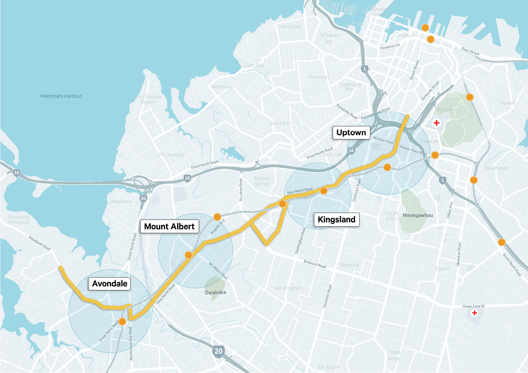
The New North Road corridor is approximately 11km long and lies within the Whau, Waitematā and Albert-Eden Local Board areas. It plays an important role in connecting Tāmaki Makaurau / Auckland's city centre to the western and central isthmus suburbs.
Download a map of the New North Road and Symonds Street upgrade (JPG 885KB).
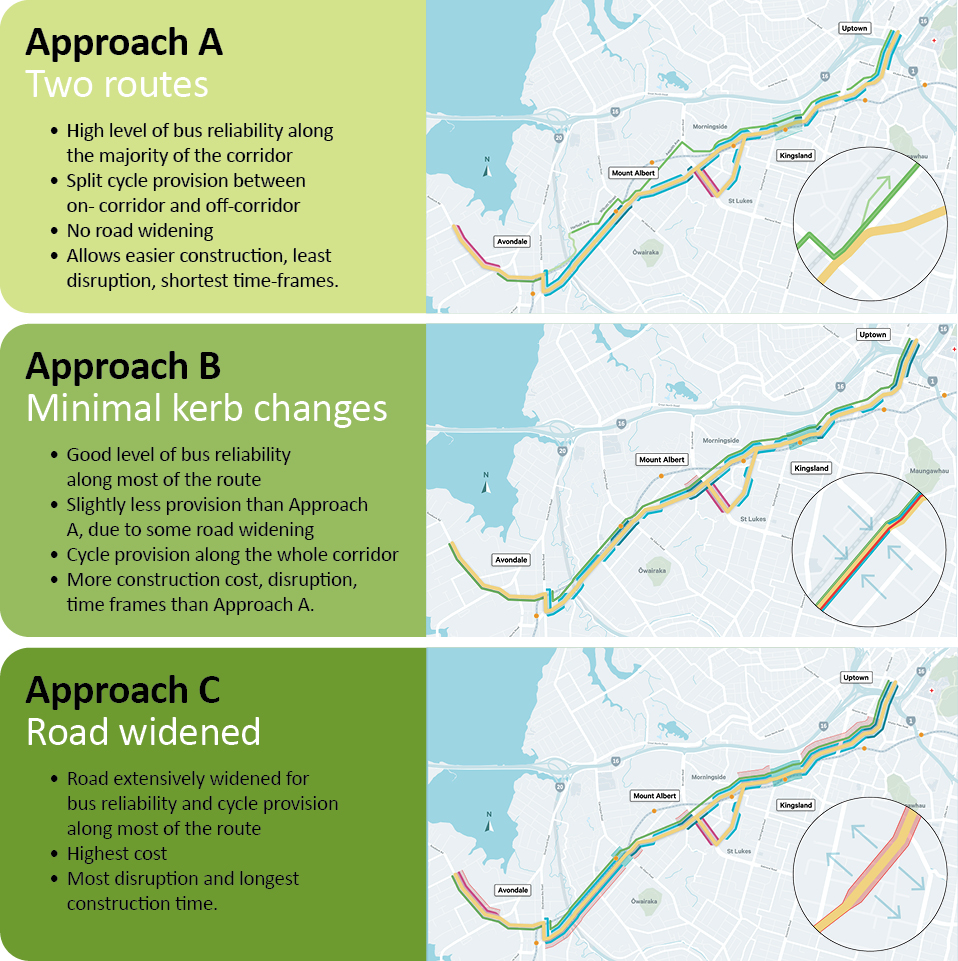
The three approaches proposed for the future of the corridor:
- Approach A: Two routes
- Approach B: Minimal kerb changes
- Approach C: Road widened
- A mix of the three approaches
View a project brochure and survey form (PDF 2MB)
View project FAQs (PDF 137KB).
View a full explainer pack (PDF 7.21MB).
Learn more about this project on our Virtual Engagement Room.

Reasons for these changes
Auckland's population is growing. As more people use our road network, we need to find safer, easier ways for people to move around the region.
We've worked with our technical team to take what we've learnt from community engagement and identify four pillars. We used these pillars to design and develop our three approaches.
Our four pillars are:
- Safety
We want to work towards our Vision Zero goal of zero deaths and serious injuries on our roads. - Thriving town centres
We want to improve street environments and create vibrant local centres where people want to live, work, and play. - Public transport and connectivity
We want to provide better transport links between town centres along New North Road, the city centre, and future developments. - Walking and cycling connections
We want to encourage cycling by giving cyclists better options and helping them feel safer.
All three approaches incorporate the pillars, just with different weightings. Your feedback will help us choose the best approach to meet our goals for a better New North Road corridor.
Learn more about the reasons for changes to New North Road and Symonds Street. (PDF 1.77MB)
Our proposed approaches
We are seeking your feedback on our proposed options (the approaches). The approaches were developed to reflect the project's four pillars, community goals, and feedback we received.
The three approaches address various issues on the New North Road corridor, each with different benefits and trade-offs.
Read a summary and explanation of the three approaches. (PDF 674KB)
Learn more about how each approach compares. (PDF 125KB)
Read the detail for each approach. (PDF 6.51MB)
We are asking you to identify which of the three approaches (or a mix of the three) you prefer for the corridor, what you think we should include, and what you think we need to change.
Next steps
Our team will:
- Analyse feedback gathered during the public consultation
- Use your feedback to inform any design changes and communicate these with the community
- Provide a public feedback report, which will be published on this webpage
- Confirm construction start dates with the community.
View the project timeline. (PDF 1.2MB)
The future of the route
The New North Road corridor plays a key role in connecting the western and central isthmus suburbs to Auckland's city centre. We expect to see significant growth in these areas - of about 40,000 new residents by 2041.

Artist's impression of how Uptown could look in the future.
Find out more about the proposed changes to Uptown. (PDF 5.29MB)

Artist's impression of how Kingsland could look in the future.
Find out more about the proposed changes to Kingsland. (PDF 4.57MB)

Artist's impression of how Mt Albert could look in the future.
Find out more about the proposed changes to Mt Albert. (PDF 4.2MB)

Artist's impression of how Avondale could look in the future.
Find out more about the proposed changes to Avondale. (PDF 3.51MB)
Alignment with other AT projects
We are aligning these upgrades with other projects within the corridor. These include the City Rail Link, Urban Cycleway Programme, Vision Zero, our 10-Year Programme, our Parking Strategy, Access for Everyone and the City Centre Masterplan.
This project also integrates other projects that affect the future of New North Road:
- Neighbourhood Cycling Links
- Kingsland Residential Parking Zone project
- Sandringham Road safety improvements
Previous project updates
Project status update 2 - Engagement update: December 2021
2 December 2021

Since our last update, the project has committed to and continued to engage with the Community Collaboration Panels. These panels are made up of representatives of various communities along the corridor.
COVID-19 restrictions have caused delays, but we have continued to work with panels and stakeholders online. We've done this engagement virtually to allow community input into the planning process. This engagement has helped us understand the views and risks perceived by the community and businesses.
If you are a business located on or near New North Road and would like to meet with the team to discuss the project, you can contact us directly at ATEngagement@AT.govt.nz
Pending approval, we're preparing to begin wider public consultations in early 2022. We'll be seeking your feedback on our proposed approaches to help us further develop an emerging option for New North Road.
We'll update this website and other AT channels, including by post and social media, when consultation begins. We also plan to run a series of live Q and A sessions, either in person or online. In this sessions, you'll be able to learn more about the project or ask the project team questions.
All project information and workshop summaries can be found on the Virtual Engagement Room.
Watch a background video on Connected Communities to learn why this project is happening.

Mount Albert Town Centre
Project status update 1 - Engagement Update: July 2021
Project status: Online engagement with Community Collaboration Panels is now underway until November
- To learn more about the project, visit the Virtual Engagement Room
- Learn about the Community Collaboration Panel work to date by visiting the Collaboration Map
- Welcome to Connected Communities videos.
Project overview
The route from Anzac Avenue in the city, along Symonds Street and New North Road to Avondale, connects West Auckland to the City Centre, through many of our central and western suburbs.
The corridor is approximately 11km long and lies within the Waitematā and Albert-Eden local board areas. It is the first corridor to be the focus of improvement under the Connected Communities programme or works.
New North Road forms part of the frequent bus network, enables access to the western rail line and provides a walking, cycling and vehicle connection over the motorway interchange to the city centre and Learning Quarter. We have identified some key issues on this route that we want to work with you to fix. These include safety, poor bus reliability, lack of separated cycle lanes, safety and thriving town centres. Over the coming years, we're likely to see significant population growth along this route and demand for safe and efficient transport will increase, so addressing these issues now is important for the future of our city.
The changes will fit in with other projects such as City Rail Link (CRL), the Urban Cycleway Programme and our 10-Year Programme. We also want to make sure the upgrades are completed to assist events such as the Women’s Football World Cup in 2023.
Benefits
- Improved safety by reducing deaths and serious injuries
- Better cycling facilities
- Improved bus reliability and public transport connections
- Supporting thriving town centres.
Timeline
- 2 February 2021 - Feedback opened
- 10 March 2021 - Feedback closed
- February to March - Public engagement
- 18 June to 2 July – Expression of Interest application open for the Community Collaboration Panels
- Mid-July – Successful applicants confirmed and announced
- July to November – Community Collaboration Panel workshops underway with key stakeholders and the community. (Note: due to Government COVID-19 Alert levels, the September and October panel workshops are now online.)
- August to Nov 2021 - Develop solutions based on feedback from initial consultation, work with Community Collaboration Panels, and investigations by AT staff.
- 1 November to December 2021 - Online community consultation
- 2022 - Emerging option developed and consents obtained
- 2023 – Construction starts in sections.
Project area
The project area includes New North Road, Symonds Street, including Anzac Avenue, Morningside Drive, St Lukes Road (from Morningside Drive to New North Road) and Rosebank Road (from Blockhouse Bay Road to Avondale Road).
New North Road provides connections to key locations, such as the universities, Eden Park and the business and retail-focused area of Kingsland, Morningside, St Lukes, Mt Albert and Avondale.

Download map of the New North Road and Symonds Street upgrade (JPG 3.01MB)
Safety risks along New North Road
Auckland Transport has adopted the Vision Zero approach to road safety where no death or serious injury on the transport network is acceptable.
On New North Road, crashes involving general vehicles are mainly around intersections with red-light running (not stopping at red traffic lights), failure to stop and give way and poor choices being common crash causes. Many high-risk intersections along the New North Road corridor also have slip lanes allowing ‘free’ turn to general vehicles, increasing the risk to vulnerable road users in these locations. Vulnerable road users are people walking or cycling, or people who are not in vehicles.
Forty-eight death and serious injury crashes (two fatalities and 43 serious injuries) have occurred along the corridor between 2014-2018.

Approximately 40% of the New North Road corridor is identified as a high-risk corridor based on the 2014-2018 crash history.
Vulnerable road users are disproportionately represented in the corridor’s crash history being involved in over 70% of all serious injuries. All the reported crashes involving vulnerable road users (pedestrians (30%), bicycles (18%) and motorcycles (28%) are clustered around intersections and high activity areas such as local centres.
Prior to the implementation of Speed Limits Bylaw 2019, the entirety of the corridor had a speed limit of 50 km/h. On 30 June 2020, this was reduced on Anzac Avenue and most of Symonds Street to 30km/hr. Find out more about the link between speeds and the outcome of a crash.
Future land use in the area
Future land use along the corridor has been identified based on the Auckland Plan 2050 and Auckland Unitary Plan (AUP(OP)). Based on the Auckland Plan, residential densification (terrace housing and apartments) is expected to occur in locations with good connections to the existing public transport network and near local centres to encourage less vehicle dependent lifestyles. It is anticipated that there will be an extra 80,000 people living close to New North Road by 2041.
The Auckland Plan also identifies that consolidation and expansion of local centres are predicted to happen within the Connected Communities timeframe. As more retail, entertainment and employment opportunities are developed within the central city and in local centres along the corridor (Avondale, Mt Albert, Morningside, Kingsland, Mt Eden), travel demand to these locations is likely to increase.
Most of the future employment growth is predicted to occur within or close to the central city whilst most of the land available for future housing is located within the outer isthmus suburbs such as Avondale, Mt Albert and St Lukes.
Most of the future employment growth is predicted to occur within or close to the central city whilst most of the land available for future housing is located within the outer isthmus suburbs such as Avondale, Mt Albert and St Lukes. This will result in increased pressure on the existing public transport network as more people commute from the outer isthmus to the central city for work or study. Additionally, most of these future trips are likely to be undertaken by public transport as the road network nears capacity.
The need for better bus efficiency
Connected Communities has identified the lack of public transport and active transport prioritisation has contributed to the dependence on private vehicles in Auckland. Narrow footpaths, lack of dedicated bus lanes or fragmented bus lanes, disconnected cycle lanes and a lack of pedestrian crossing points and easy to access bus interchange points have all contributed to this.
Current projections show that by 2028, the predicted bus travel time between Avondale and the City Centre will be 89 minutes.
Approximately 131 buses per hour travel along the busiest section of Symonds Street during peak periods which reduces to 55 buses per hour during off-peak periods. Along the section of New North Road to the west of Mt Eden Road, approximately 41 buses per hour at peak times operate along the corridor which reduces to 13 buses per hour during the off-peak.
Existing bus priority measures are available on approximately 2.3 km of the New North Road corridor with most of this being in the city centre (Anzac Avenue and Symonds Street). The absence of dedicated bus priority on most of the corridor requires buses to share road space with general traffic and can result in buses having a slower and more unreliable journey time due to being stuck in traffic, particularly in locations that experience congestion during peak periods.
Cycling
Accessing the central city and Symonds Street using existing facilities is currently unattractive due to limited connections between the Grafton Gully cycleway and Symonds Street. The connections which do exist are of a steep grade and shared with general traffic.
A key pinch point between Symonds Street and the remainder of the corridor is the Symonds Street motorway bridge and although a shared path exists, this is not up to the current Transport Design Manual standards. The alternative, mixing with general traffic is undesirable due to the high volumes of general traffic (of which buses make up a high proportion).
For the remainder of the corridor, there is no close by cycle routes with the only exception being the Northwestern cycleway. This is approximately 200m away from the corridor at Kingsland and 1km away from the corridor at Mount Albert. Despite this being close to the corridor, there is currently no safe and attractive cycling facilities connecting New North Road and the Northwestern cycleway.
Only 250 metres of safe cycle infrastructure is available on the entire route.
Cycling to train stations to use multiple different travel options during a journey is also currently unattractive along the New North Road route. Of the five currently open stations (Mt Eden is closed due to CRL redevelopment works) only Kingsland has existing limited bike parking.
The attractiveness of cycling to access employment and education remains low along the New North Road corridor in comparison to other transport modes. Census data shows that more ‘cycle to work trips’ occur with proximity to the city centre and where there is existing cycle infrastructure.
Two of the factors likely to increase the attractiveness of cycle journeys are shortening the length of the journey and the availability of attractive cycling lanes. It is expected that the number of cycling journeys will increase with the development of safe and accessible cycle paths along the route or parallel to the route.
Public engagement
We are working closely with local communities to make bold choices for the future.
The first stage of consultation closed on 10 March 2021. You can find the public feedback report and a summary of this report below:
- Public feedback report – Phase One
- Summary of findings from Phase One of public feedback
- Visit Social Pinpoint for an interactive map
We have established four Community Collaboration Panels, made up of local community members and stakeholders, to make sure local considerations are factored into future designs. Each panel brings together a diverse group of people from the community to discuss feedback from the wider public, share their knowledge of the community and further develop options for the corridor. We have also established a Whole of Corridor Panel, to reflect the needs of the entire corridor as a major transportation route.
An online portal has been created as part of the engagement process. To explore the project Virtual Engagement Room, click here.
If you have any questions about the Community Collaboration Panels, project progress or community engagement, please email ATEngagement@at.govt.nz
For more information: Contact Auckland Transport