Planned minor improvements Planned minor improvements
AT will be implementing minor road improvements in Auckland to make it a safer and better place to live for all Aucklanders.
Go to our road works and disruptions page for information on road closures.
Search by suburb or street name in the search bar below to find planned minor improvements in your area.
| Location (suburb, street) | Type of work being done | Planned start | Project drawings |
|---|---|---|---|
| Tennyson Street, Balmoral |
We’re making parking better on Tennyson Street, Balmoral. This follows a request from the Albert-Eden Local Board. The taxi stand on the western side of the Tennyson Street and Dominion Road intersection is underused. We will change it to three P60 parking spaces. The time restriction will apply from Monday to Sunday, 8am to 6pm. Benefits to your neighbourhood There will be more parking for everyone and easier access to local shops and services. It encourages more people to enjoy the area and support local businesses. Outside of the time restriction, people can park for longer periods. Contact us If you have any queries or concerns about this project, email atengagement@at.govt.nz. In the subject line, put RTV-673. |
Between January and February 2026 |
Download Tennyson Street proposal drawing (JPG, 159KB) |
| Kawau Road, Greenlane |
September 2025 update In June 2025, we let you know about our plan to paint broken yellow lines (no stopping at all times) near the chicane by 16A Kawau Road. We heard concerns from the community about a blind spot along the bend between 23 and 27 Kawau Road. Cars parked on both sides make it hard for vehicles to pass. We did more site observations to better understand how the street is being used. Design updates Based on what we observed and heard, we made changes to better reflect community input. We will no longer paint broken yellow lines (no stopping at all times) near the chicane by 16A Kawau Road. We will remove a single kerbside parking space. We now plan to:
These changes will improve traffic flow, visibility and enhance accessibility by providing a wider manoeuvring space. Contact us If you have any queries or concerns about this project, email atengagement@at.govt.nz. In the subject line, put BYL-723. |
December 2025 |
|
| Gilgit Road, Epsom |
We’re making changes to improve access to utility services near the intersection of Gilgit Road and Mountain Road. The Vector electricity maintenance team has asked us to extend the ‘no stopping at all times’ (broken yellow lines) in front of the electrical box. When vehicles park in this area, they block access. This makes it hard to switch the power during faults or maintenance work. Changes We will:
The changes will make it easier and quicker for the Vector maintenance team to access the site when needed. Contact us If you have any queries or concerns about this project, email atengagement@at.govt.nz. In the subject line, put BYL-747. |
Between November and December 2025 |
Download Gilgit Road, Epsom proposal drawing (JPG, 108KB) |
| Captain Springs Road, Onehunga |
Auckland Transport is planning to make the pedestrian crossing on Captain Springs Road safer. The crossing is near the gate outside Te Papapa School. In response to community concerns, we aim to make the crossing safer and more accessible for everyone, especially school children. We want to make it easier to see pedestrians, and encourage drivers to go slower near the school. What we’re changing We will:
We’ll update residents and school communities closer to the time. If you have any feedback, email atengagement@at.govt.nz. In the subject line, put ‘Captain Springs Road – Pedestrian Improvement’. |
Late 2025 |
Download Captain Springs Road, Onehunga proposal drawing (PDF, 1.4MB) |
| Sunnyview Avenue, Shelly Park |
We plan to make it safer for children and families to get to Shelly Park Primary School. This is in response to community concerns about the lack of crossing facilities on Sunnyview Avenue. This project is funded through the Local Board Transport Capital Fund. It is supported by the Howick Local Board. Auckland Transport is delivering the project on their behalf. Before construction begins, we will contact residents directly affected by the works. Key changes Shelly Park Primary School and the community dental clinic will be more accessible. It will be easier for tamariki and whānau to walk, bike or scoot to school. Road markings and parking changes will make it easier to see pedestrians. This will make them safer. We will:
Contact us If you have questions or feedback:
|
December 2025 |
Download Sunnyview Avenue, Shelly Park proposal drawing (PDF, 1.1MB) |
| 25 Athenic Avenue, Lynfield |
Halsey Drive School has asked the Puketāpapa Local Board to make Athenic Avenue safer for pedestrians. Auckland Transport is proposing to install a pedestrian crossing on their behalf. This project is funded by the Local Board Transport Capital Fund. Planned changes The proposed pedestrian crossing will be outside 25 Athenic Avenue. It will feature kerb ramps to make it easier for those with strollers or wheelchairs to get between the footpath and the road. It will also include:
This crossing will prioritise pedestrian safety. It will also give school children a safer route to get to and from Halsey Drive School. Community benefits The crossing will enhance safety and accessibility for residents, particularly school children. It will also lessen the risk of accidents and make the neighbourhood more walkable. |
September 2025 |
Download Athenic Avenue, Lynfield proposal drawing (PDF, 455KB) |
| Te Pai Place and Universal Drive, Henderson |
We’ll be installing ‘no stopping off roadway’ (no parking on berms) signs along Te Pai Place and Universal Drive. To see where this restriction will apply, download the design drawing. Why this is important Vehicles parked on the grass berm make it hard to see people and street signs at intersections. Parking on berms is a danger to people on foot. The cars block them from view, meaning they can’t be seen crossing roads or walking. It makes it harder for:
Parking on the berm can damage underground utilities and the grass, especially in wet weather. The signs will tell drivers not to park on the grass berms. They will also warn that these areas will be subject to parking enforcement. We remind all drivers to park correctly and avoid blocking driveways. Vehicles parked illegally may get infringement notices or be towed away. To speak to us about our plans, email parkingconsultation@at.govt.nz. |
September 2025 |
Download Te Pai Place, Onehunga proposal drawing (PNG, 767KB) |
| Galway Street, Onehunga |
Local businesses have asked us to remove the parking spaces on the east side of Galway Street. Trucks and other vehicles are parking there. This blocks access for larger vehicles that need to use the street for business. With cars parked on both sides, the road is too narrow for 2-way traffic. This makes it hard for cars to safely exit 100 Neilson Street. To fix this, we plan to paint more broken yellow lines (no stopping at all times). They will be on the east side of Galway Street just before the intersection with Neilson Street. The lines on the corner will be extended to the driveway opposite 36 Galway Street. We will remove 8 parking spaces. These changes will:
|
December 2025 |
Download Galway Street, Onehunga proposal drawing (PDF, 678KB) |
| Sims Road, Penrose |
Planned update In July 2025, we told you our plan to paint 4m of no stopping at all times (broken yellow lines). We planned to paint them on the left side of the driveway at 7 Sims Road. This is next to the recently painted hockey sticks. We got feedback from a local business about how hard it is for heavy vehicles to access the area. So, we did more site observations. Based on what we saw and heard, we’ve updated the plan. What’s changing We’re now planning to:
These changes will make it easier for all vehicles, especially heavy vehicles, to access Sims Road and nearby businesses. Contact us If you have any queries or concerns about this project, please email atengagement@at.govt.nz. In the subject line, put BYL-728.
|
December 2025 |
Download Sims Road, Onehunga updated proposal drawing (JPG, 163KB) |
| Wallath Road, Onehunga |
We plan to make changes to Wallath Road to improve visibility and driver safety. Residents are concerned that cars parked along the bend of Wallath Road, makes the road narrower. This forces drivers to move into the centre of the road to get through the bend. The parked cars also make it harder for drivers to see oncoming vehicles and increases the risk of head-on crashes with cars coming from the other direction. We are proposing to:
The broken yellow lines will end 6 metres south and 17 metres east from the driveway of 11a Wallath Road. This will require removing 3 parking spaces. |
December 2025 |
Download Wallath Road, Onehunga drawing (PDF, 280KB) |
| Potaka Lane, Jellicoe Road, and Pleasant View Road, Panmure |
Some on-street and kerb spaces will be allocated for bus parking. They include:
Why we're making these changes We need to provide adequate parking spaces and nearby recharging facilities for the high number of electric buses operating from Panmure Station.
Pleasant View Road: Design update We'll still paint road markings, 'Bus Bay' on the northern side of Pleasant View Road, west of the Fire and Emergency New Zealand, Region Training Centre entrance. These changes will not impact the movement of emergency services vehicles or operations.
|
July 2025 |
Download making space for bus parking around Panmure Station (PDF, 1.3MB) |
| West Tamaki Road and Roberta Avenue intersection, Glendowie |
We have received requests from the community and the Ōrākei Local Board members to improve road safety at the intersection of West Tamaki Road and Roberta Avenue. In June 2025, we updated the design after listening to community feedback. We are planning to make the following changes:. Paint broken yellow lines We will paint broken yellow lines (no stopping at all times) on the left corner of the intersection outside 69 to 73 Roberta Avenue. The broken yellow lines will stop parked vehicles from blocking the view of oncoming traffic. This will make it:
Remove on-street parking spaces To make space for the broken yellow lines, we will remove 2 on-street parking spaces outside 69 to 73 Roberta Avenue near the intersection. |
September 2025 |
Download West Tamaki Road and Roberta Avenue intersection proposal drawing (PDF, 644KB) |
| Macpherson Street, Meadowbank |
Residents of Macpherson Street told us that when cars are parked along the kerb at the head of the cul-de-sac, it becomes difficult for vehicles to turn around. It is especially hard for larger trucks like waste collection and emergency service vehicles. To fix this, we will:
In good weather conditions, it will take one day to paint the broken yellow lines. We know this may cause an inconvenience, and we’ve tried to minimise this. Vehicles parked illegally on the new broken yellow lines may receive infringement notices or be towed away. |
September 2025 |
|
| 231 to 237 Mount Wellington Highway |
We'll be enhancing footpath safety and accessibility around 231 to 237 Mount Wellington Highway. We've received requests from the community to provide better footpaths and safer facilities for pedestrians and people using mobility devices between the Mount Wellington Shopping Centre and Hamlin Road. In response, we're planning to upgrade the existing footpath from 231 to 237 Mount Wellington Highway. This includes widening the footpath and reducing the slope, making it safer to walk and more accessible for people on mobility scooters, wheelchairs and prams. The changes we're planning are:
|
Expected timeline late 2025 |
Download Mount Wellington Highway footpath proposal drawing (PDF, 1.8MB) |
| Kitchener Road, Sandringham |
We will change the existing taxi stand outside 1A Kitchener Road into 2 general parking spaces with a P30 time restriction. The time restriction will apply from Monday to Sunday, 8am to 6pm. We will also paint 5 more metres of broken yellow lines (no stopping at all times) on the west side of the Kitchener Road and Sandringham Road intersection. We will extend the broken yellow lines from the corner to the first parking space in the taxi stand. It will help drivers see people crossing the road and make it safer for both drivers and pedestrians. This will benefit the community because:
|
Between July and August 2025 |
Download Kitchener Road proposal drawing (PDF, 233KB) |
| Melanesia Road, Kohimarama |
We're improving pedestrian safety on Melanesia Road, near the intersection with Baddeley Avenue. We’re proposing to:
We also propose removing 2 parking spaces:
We expect to start construction on 11 June 2025. This project is part of the Local Board Transport Capital Fund (LBTCF). It was initiated by the Orakei Local Board. Contact atengagement@at.govt.nz |
June 2025 |
Download Melanesia Road proposal drawing (PDF, 585KB) |
| Bridge structures renewals package 2, multiple locations |
Agile Infrastructure will be carrying out minor bridge structure renewals at multiple locations during May and June 2025. When we’ll be working We’ll mainly carry out the work during the day between 7am and 7pm. We’ll limit night work as much as possible. However, there may be some work that we need to do at night to lessen disruption and keep everyone safe. When needed, we’ll schedule night works between 8pm and 5am. What we’re doing We’re doing culvert repairs, bridge repairs, drainage and clean up areas around the bridges and culverts at multiple locations. We’ve provided a list of locations below, the scope of work and planned dates. We’ll try to start the work on time but factors outside our control, such as weather could mean a delayed timeline. If the delay is significant, we’ll notify you. 80 Tunnel Road Dates: 19 May to 23 May 2025 This work will be carried out under a shoulder closure, we do not anticipate traffic to be impacted by this work. 90 Old Pine Valley Road Dates: 19 May to 23 May 2025 This work will be carried out under a shoulder closure, we do not anticipate traffic to be impacted by this work. 157 Target Road Dates: 19 May to 23 May 2025 This work will be carried out under a shoulder closure, we do not anticipate traffic to be impacted by this work. 164 South Head Road Dates: 2 June to 20 June 2025 This work will be carried out a stop / go traffic operation, please follow all signs and traffic directions. 57 Awanohi Road Dates: 26 May to 20 June 2025 This work will be carried out under a shoulder closure, we do not anticipate traffic to be impacted by this work. Makora Road Dates: 26 May to 26 June 2025 This work will be carried out under a shoulder closure, we do not anticipate traffic to be impacted by this work. 113 North Road Dates: 2 June to 20 June 2025 This work will be carried out under a shoulder closure, we do not anticipate traffic to be impacted by this work. Elmdon Street Dates: 2 June to 20 June 2025 This work will be carried out under a shoulder closure, we do not anticipate traffic to be impacted by this work. Between Lambie Drive and Wiri Station Road Dates: 2 June to 20 June 2025 This work will be carried out under a shoulder closure, we do not anticipate traffic to be impacted by this work. Traffic controllers will be on-site to assist with directing traffic and ensuring safety. Contact us If you have any queries or concerns about this project, please contact AT: Email: projects@at.govt.nz If you have any queries related to the construction, please contact Agile Infrastructure: Project Manager: Jay Dangwal |
From May 2025 to June 2025 |
Download information about the bridge structures renewals package 2 (PDF, 111KB) |
| Upgrading Bus Stops on Pupuke Road and Birkenhead Avenue |
We propose to relocate and upgrade bus stops on Pupuke Road in Hillcrest, and Birkenhead Avenue in Birkenhead. The changes we’re proposing The enclosed drawing shows these improvements in more detail. 6 and opposite 6 Pupuke Road, Hillcrest – School bus stop We'll upgrade school bus stops with new footpath areas, road markings and signage. We'll install additional broken yellow lines at the bus stops to improve bus manoeuvrability. 60 Pupuke Road, Hillcrest – Stop 3988 We'll relocate and upgrade bus stop at 62 Pupuke Road with a new bus shelter, footpath area, road markings and signage. The new bus shelter will provide a more protected environment for passengers waiting for the bus, particularly during the wet weather. 51 Pupuke Road, Hillcrest – Stop 3864 We'll upgrade bus stop with a new bus shelter, footpath areas, road markings and signage. The new bus shelter will provide a more protected environment for passengers waiting for the bus, particularly during the wet weather We'll install additional broken yellow lines at the bus stops to improve bus manoeuvrability. 47 and 60 Pupuke Road, Hillcrest – Crossing facility We'll install new pedestrian refuge islands to provide safer access to the bus stops. We'll install additional broken yellow lines to improve pedestrian visibility. 171 Birkenhead Avenue, Birkenhead – Stop 3897 We'll relocate bus stop and bus shelter, footpath areas, road markings and signage We'll install additional broken yellow lines at the bus stop to improve bus manoeuvrability. These changes will result in some on-street parking loss but will:
How this will benefit your neighbourhood The improved bus stops will allow the neighbourhood to better access bus services and increase safety for both road users and pedestrians. Tell us what you think Here’s how you can have your say until 6 June 2025: |
Public engagement is running from 23 May 2025 to 6 June 2025. |
Download Pupuke Road and Birkenhead Avenue proposal drawings (PDF, 975KB) |
| 265 Saint Johns Road, Saint Johns |
Alongside the Ōrākei Local Board, we are planning to:
While we are only moving the bus stop a few metres, it will improve bus operations, safety, functionality and overall convenience for passengers. The new bus shelter will provide protection from rain or wind and offer a place to sit while waiting for the bus. We will also:
This project is supported by the Ōrākei Local Board and delivered by Auckland Transport on their behalf funded through the Local Board Transport Capital Fund. This fund is used to make improvements based on community priorities, which may not be covered by other programmes of work. |
Between July and August 2025 |
Download Saint Johns Road proposal drawing (PDF, 1.5MB) |
| Mcquoids Road, Flat Bush |
We received several requests from residents to extend broken yellow lines (no stopping at any time). In response, we changed the plan to extend the broken yellow lines from 1C to 9B McQuoids Road along the west side of the road. This change did not require the removal of any existing parking spaces. This work is now complete. |
Completed in early 2025 |
|
| Boon Street and Mahia Road, Manurewa |
Residents told Auckland Transport that the lefthand turn is hard due to parked vehicles. We will install a ‘no stopping at all times’ (broken yellow lines) parking restriction at the Boon Street and Mahia Road intersection. This will increase safety by giving approaching drivers enough sight distance that they are aware of pedestrians and a crossing. Installing broken yellow lines will result in 3 car park losses. |
Before July 2025 |
Download Khyber Pass Road proposal drawing (PDF, 663KB) |
| Khyber Pass Road, Grafton |
We will be improving the safety and operation of bus stop 7170 at 68 Khyber Pass Road. The community and bus operators have asked us to improve this bus stop to make the neighbourhood safer and easier to get around. To see where we’ll be working, download the proposal drawing. The work we’re doing We’re upgrading the bus stop with new road markings and signage. How this will benefit your neighbourhood The neighbourhood will have better access to bus services. Road users and pedestrians will be safer. What happens next We’ll write to you again soon with more details about the start of the works. Contact us If you have any information we need to know, please email us by 19 May 2025: projects@at.govt.nz. |
Public inform from |
Download Khyber Pass Road proposal drawing (PDF, 591KB) |
| Richmond Road, Grey Lynn |
We will be moving and upgrading bus stop 8084. The community and bus operators have asked us to improve this bus stop to make the neighbourhood safer and easier to get around. The work we’re doing We will move the bus stop from 224 to 204 Richmond Road. We will also upgrade the:
Benefits The neighbourhood will have better bus services. Road users and pedestrians will be safer. The bus stop will be close to the zebra crossing, making it safer to cross the road. What happens next We’ll write to you again soon with more detail about the start of works. Contact us If you have any information we need to know, please email us by 19 May 2025 at projects@at.govt.nz. |
Public inform from 5 May to 19 May 2025 |
Download Richmond Road proposal drawing (PDF, 1.5MB) |
| Bruce McLaren Road, Henderson |
Based on feedback from the community and bus operators, we propose:
For more details, see the proposal drawing. New stop outside 128 Bruce McLaren Road We will combine bus stops 5522 (110 Bruce McLaren Road) and 5520. We will upgrade the footpath area, road markings and existing signage. We will also:
New stop outside 119 Bruce McLaren Road We will combine bus stops 5499 (137 Bruce McLaren Road) and 5501. We will:
Crossing facility by 119 and 124 Bruce McLaren Road We will install new pedestrian refuge islands to give safer access to the bus stops. These changes will lead to some on-street parking loss, but:
How this will benefit your neighbourhood The bus route will be more efficient. The existing bus stops are close together, so buses slow down and stop more often. The improved stops will more accessible and safer for both road users and pedestrians. Contact us You can have your say until 19 May 2025 by emailing projects@at.govt.nz. |
Public engagement from 5 May to 19 May 2025 |
Download Bruce McLaren Road proposal drawing (PDF, 788KB) |
| Lingfield Street, Glenfield |
We'll be improving the safety and operation of bus stops along Lingfield Street in Glenfield. Feedback from the community and bus operators indicates that these bus stops should be improved. The community has expressed that safe and easy mobility within the neighbourhood is important. The work we’re doing We’re doing this work to maintain and improve the public transport options in your area and to keep you safe. The drawings show where we’ll be working. 1 Lingfield Street, Glenfield - Stop 3749 improvements include:
12 Lingfield Street, Glenfield - Stop 3902 improvements include:
47 Lingfield Street, Glenfield - Stop 3747 improvements include:
50 Lingfield Street, Glenfield - Stop 3900 improvements include:
How this will benefit your neighbourhood The improved bus stops will allow the neighbourhood to better access bus services and increase safety for both road users and pedestrians. What happens next We’ll write to you again soon with more detail about the commencement of works. Contact us If you have any information we need to know, email us at projects@at.govt.nz by19 May 2025. |
Public engagement is running from 5 May to 19 May 2025. |
Download Lingfield Street bus stop improvements map (PDF, 536KB) |
| Kitchener Road, Milford |
We propose to improve the safety and operation of the bus stop located in front of 50 Kitchener Road in Milford. Feedback from the community and bus operators indicates a desire for improvements to this bus stop. The community has expressed that safe and easy mobility within the neighbourhood is important. The changes we’re proposing The enclosed drawing shows these improvements in more detail. We propose to upgrade the existing bus stop including constructing a new bus shelter, road markings, and signage. This will provide a more protected environment for passengers waiting for the bus, particularly during wet weather. Contact us If you have any information we need to know, email us at projects@at.govt.nz by 16 May. |
Public engagement is running from 30 April to 16 May 2025. |
Download Kitchener Road bus stop improvements plan (PDF, 1.1MB) |
| Casuarina Road, Highland Park |
We're improving the safety and operation of bus stop 6151 on 79 Casuarina Road in Highland Park. The changes we're making
We're also upgrading the bus stop to meet current standards with:
This will provide a more protected waiting area for passengers. These changes will result in some on-street parking loss but will:
The improved bus stops will allow the neighbourhood to better access bus services and increase safety for both road users and pedestrians. Contact us If you have any information we need to know, email us at projects@at.govt.nz by 19 May 2025. |
Public engagement 30 April 2025 to 16 May 2025 |
Download Casuarina Road bus stop upgrades map (PDF, 1MB) |
| East Coast Road, Forrest Hill |
We propose to improve the safety and operation of the bus stop outside 156 East Coast Road. The community and bus operators have asked us to improve this bus stop to make the neighbourhood safer and easier to get around. For more details, download the proposal drawing. Upgrades to stop 3274 We will build a new bus shelter, footpath area, road markings and signage. This will help protect passengers waiting for the bus, particularly during wet weather. Contact us If you have any information we need to know, email us at projects@at.govt.nz by 19 May 2025. |
Public engagement 30 April 2025 to 16 May 2025 |
Download East Coast Road proposal drawing (PDF, 1.1MB) |
| 167 Jervois Road, Herne Bay |
We'll be improving the safety and operations by upgrading bus stop 7119 on Jervois Road in Herne Bay. Feedback from the community and bus operators indicates a desire for improvements to this bus stop. The community has expressed that safe and easy mobility within the neighbourhood is important. The changes we're making We're:
These changes will result in some on-street parking loss but will:
How this will benefit your neighbourhood The improved bus stop will allow the neighbourhood to better access bus services and increase safety for both road users and pedestrians. What happens next We’ll write to you again soon with more detail about the start of physical works. Contact us If you have any information we need to know, email us at projects@at.govt.nz by 19 May 2025. |
Public engagement is running from 5 May to 19 May 2025. |
|
| Church Street, Onehunga |
We propose to upgrade, relocate, and improve the safety and operation of bus stops:
Feedback from the community and bus operators shows a desire for improvements to these bus stops. The community has told us that safe and easy mobility within the neighbourhood is important. The changes we're proposing to stops 8156 and 1025 We propose to:
The changes we're proposing to stops 8158 and 8161 We propose to relocate the existing bus stop outside 192 Church Street to outside 200A Church Street. This includes relocating and installing:
This change is proposed as the current bus shelter is not fit for purpose and lies along a large flood plain. Other changes include:
These changes will mean some on-street parking loss but will:
Why we're doing this The improved bus stops will give the neighbourhood better access to bus services and increase safety for both road users and pedestrians. Contact us If you have any information we need to know, email us at projects@at.govt.nz by 16 May 2025. |
Public engagement 30 April to 16 May 2025 |
Download Church Street bus stop upgrades map (PDF, 588KB) |
| Glamorgan Drive, Torbay |
We propose to upgrade, relocate and improve the safety and operation of bus stops along Glamorgan Drive. Feedback from the community and bus operators indicates a desire for improvements to these bus stops. The community has expressed that safe and easy mobility within the neighbourhood is important. The changes we’re proposing The enclosed drawing shows these improvements in more detail. 237 and 258 Glamorgan Drive, Torbay – Stops 4133 and 3069 changes include:
177 and 194 Glamorgan Drive, Torbay – Stops 3049 and 3058 changes include:
139, 145 and 152 Glamorgan Drive, Torbay – Stops 3060 and 3051 changes include:
94 and 99 Glamorgan Drive, Torbay – Stops 3030 and 3085 changes include:
33 and 38 Glamorgan Drive, Torbay – Stops 3025 and 3028 changes include:
These changes will result in some on-street parking loss but will:
The improved bus stops will allow the neighbourhood to better access bus services and increase safety for both road users and pedestrians. Contact Us
If you have any information we need to know, email us at projects@at.govt.nz by 16 May 2025. |
Public engagement is running from 30 April to 16 May 2025. |
Download Glamorgan Drive bus stop improvements map (PDF, 1.8MB) |
| Beach Road, Torbay |
We propose to combine and improve the safety and operation of bus stops:
Feedback from the community and bus operators indicates a desire for improvements to these bus stops. The community told us safe and easy mobility within the neighbourhood is important. Proposed changes For more details, download the proposal drawing. At 1009 Beach Road, Torbay, we will move bus stop 3003 and the bus shelter to outside 1001 Beach Road. This will allow us to install new pedestrian refuge islands nearby. At 989 Beach Road, Torbay, we will combine bus stop 3005 with bus stop 3003. It will be located outside 1001 Beach Road. At 1082 Beach Road, Torbay, we will upgrade bus stop 3002. The upgrade will involve installing a new bus shelter. This will help protect passengers waiting for the bus, particularly during wet weather. At 1064 Beach Road, Torbay, we will combine bus stop 3004 with bus stop 3002. The new stop will be outside 1082 Beach Road. At the crossing facility by 1005 Beach Road and 1080 Beach Road, Torbay, we will install new pedestrian refuge islands. It will make it safer for pedestrians to:
There will be some on-street parking loss, but it will mean that customers can get on and off buses safely and comfortably. How this will benefit your neighbourhood Making 2 sets of bus stops into one set with a safe crossing facility will make the bus route more efficient. These bus stops are close together which requires buses to slow down and stop more often. Contact us If you have any information we need to know, email projects@at.govt.nz by 16 May 2025. |
Public Engagement from 30 April 2025 to 16 May 2025 |
Download Beach Road proposal drawing (PDF, 741KB) |
| 147 Parkhurst Road, Parakai |
We propose improving bus stop infrastructure at 147 Parkhurst Road in Parakai by relocating two bus stops to a safer and more accessible location for bus users. This will include a new pedestrian refuge crossing between the bus stops. The changes we’re proposing The enclosed drawing shows these improvements in more detail. We'll:
These changes will result in some on-street parking loss but will:
The improved bus stops will allow the neighbourhood to better access bus services and increase safety for both road users and pedestrians. Improving our customers’ experience on public transport is important to us. Enhanced accessibility, reliability and frequency of bus services and routes connects you to schools, sports, local amenities and work. Contact us If you have any information we need to know, email us at projects@at.govt.nz by 16 May 2025. |
Public engagement is running from 30 April to 16 May 2025. |
|
|
Prince Regent Street, Half Moon Bay |
We propose to upgrade and improve the safety and operation of bus stops 6111 and 6112 located at 45 and 60 Prince Regent Street, Half Moon Bay. Feedback from the community and bus operators indicates a desire for improvements to these bus stops. The community has expressed that safe and easy mobility within the neighbourhood is important. The changes we are proposing We're:
These changes will result in some on-street parking loss but will:
The improved bus stops will allow the neighbourhood to better access bus services and increase safety for both road users and pedestrians. Contact us If you have any information we need to know, email us at projects@at.govt.nz by 16 May 2025. |
Public engagement is running from 30 April to 16 May 2025. |
Download Prince Regent Drive bus stop upgrades map (PDF 1.5MB) |
|
Beachcroft Avenue, Onehunga |
We propose to upgrade, relocate and improve the safety and operation of bus stops 1727 and 1618. They are at 30 Beachcroft Avenue and Opposite 30 Beachcroft Avenue in Onehunga. Feedback from the community and bus operators shows a desire for improvements to these bus stops. The community has said that safe and easy mobility within the neighbourhood is important. The improved bus stops will give the neighbourhood better access to bus services, and increase safety for road users and pedestrians. Changes we're proposing at stop 1727 opposite 30 Beachcroft Avenue
Changes we're proposing at stop 1618 outside 30 Beachcroft Avenue At this location we'll:
The street will lose some on-street parking but will:
Contact us If you have any information we need to know, email us at projects@at.govt.nz by 16 May 2025. |
Public engagement is running from 30 April to 16 May 2025. |
Download Beachcroft Avenue bus stop upgrades map (PDF, 711KB) |
|
Business Parade, East Tamaki |
We propose to upgrade and improve the safety and operation of bus stops 2073 and 2090 located on 8 Business Parade South in East Tamaki. Feedback from the community and bus operators shows a desire for improvements to these bus stops. The community has expressed that safe and easy mobility within the neighbourhood is important. The changes we're proposing We're:
There will be no changes to on-street parking arrangements are proposed as part of this project. Why we're making these changes The improved bus stops will:
Contact us If you have any information we need to know, email us at projects@at.govt.nz by 16 May 2025. |
Public engagement is running from 30 April to 16 May 2025. |
Download Business Parade South bus stop upgrades map (PDF, 824KB) |
|
Various sites across northwest Auckland |
We are proposing minor safety improvements in northwest Auckland. We will install them at intersections and along road corridors to address various types of crashes. We will use low-cost solutions to improve safety. Solutions include installing:
The sites included in this work are:
This work will be completed by 30 June 2025. East Coast Road and Wilks Road, Dairy Flat, is due to be completed by 30 June 2026. Contact us If you have any queries or concerns about this project, please email atengagement@at.govt.nz |
This financial year |
Download Old North Road and Deacon Road proposal drawing (PDF, 2.3MB)
Download Pine Valley Road and Kahikatea Flat Road proposal drawing (PDF, 2.3MB)
Download Woodcocks Road proposal drawing (PDF, 2.8MB)
Download Carlisle Road and Finchley Road proposal drawing (PDF, 2.2MB)
Download East Coast Road and Wilks Road proposal drawing (PDF, 2.7MB)
Download East Coast Road and Spur Road proposal drawing (PDF, 1.3MB)
Download Sandspit Road and Mahurangi East Road proposal drawing (PDF, 2.2MB)
Download Taylor Road proposal drawing (PDF, 2.5MB)
Download Oraha Road and Koraha Road proposal drawing (PDF, 2.4MB)
Download Sharp Road proposal drawing (PDF, 8.6MB)
Download Green Road proposal drawing (PDF, 4MB) |
|
Various sites across southeast Auckland |
We are proposing minor safety improvements at several locations across south Auckland. These projects are part of a package of road safety measures across the Auckland network. They aim to make high-risk locations and bends safer on both rural and urban roads. The proposed treatments include one or more of the following:
The sites included in this work are:
We plan to start construction this financial year. Works might extend into the next financial year if there are unforeseen problems. Contact us If you have any queries or concerns about this project, please email atengagement@at.govt.nz. |
This financial year |
Download Bairds Road proposal drawing (PDF, 2.6MB)
Download Orams Road proposal drawing (PDF, 1.3MB)
Download Awhitu Road proposal drawing (PDF, 1.4MB)
Download Porchester Road proposal drawing (PDF, 4MB)
Download Great South Road proposal drawing (PDF, 1MB)
Download Papakura-Clevedon Road proposal drawing (PDF, 3.4MB)
Download 865 Whitford-Maraetai Road proposal drawing (PDF, 3.7MB)
Download 603 Whitford-Maraetai Road proposal drawing (PDF, 4.2MB)
Download Glenbrook Waiuku Road proposal drawing (PDF, 4MB)
Download Maraetai Drive proposal drawing (PDF, 2.7MB)
Download West Road proposal drawing (PDF, 4.5MB) |
|
25 Sutherland Road, Mount Albert |
We are proposing to extend the broken yellow lines on the southern side of the intersection of Sutherland Road and Carrington Road by 6m. This will make it safer for cyclists by giving more visibility to users of the cycle on/off ramp in front of 25 Sutherland Road. Cyclists currently have visibility issues at the cycle on/off ramp due to vehicles parking too close. Sutherland Road is a low-traffic route. Cycling is promoted here because it is near the Northwestern Cycleway. There is a cycle ramp on Sutherland Road to help cyclists use the Carrington Road shared path. From here, cyclists can use the lane in either direction to get on the Northwestern Cycleway. They can also cross Carrington Road at the crossing to travel in either direction. When put in place, these changes will result in the loss of one parking space. |
Before June 2025 |
|
|
Dennis Avenue bus stop relocation |
We engaged with the community on our plans to relocate a pair of bus stops on Dennis Avenue, Hill Park in October 2023. We're now starting construction.. The changes we're making The new bus stops will have new tactile pavers, hard stand areas and seating to improve overall amenity. Contact Us For any information or concerns about this project, email projects@at.govt.nz. |
May 2025 |
Download Dennis Avenue bus stop relocation drawing (PDF, 367KB) |
|
165 Great South Road, Northcrest shops and 4 Halver Road, Manurewa |
Auckland Transport has received requests from the community to make some parking changes to mobility parking spaces in the Manurewa Town Centre. We have identified two locations suitable for these changes. 165 Great South Road, Northcrest shops Mobility parking change We plan to make the mobility parking space wider by removing the parking space next to it. Despite the yellow lines marking the space, other drivers often park over them, blocking the mobility parking user from opening their car door widely and accessing the footpath ramp. 4 Halver Road Halver Road will undergo changes due to its proximity to a medical centre, physiotherapy clinic and dental clinic. The nearest other mobility park is over 100 metres away. We propose to covert the existing P15 loading zone outside 4 Halver to a P180 mobility parking space and relocate the P15 loading zone to the opposite side or the road. To fit in the P15 loading zone, we'll need to remove the existing taxi parking space. Changes and benefits The changes we’re making by June 2025 will improve parking accessibility and safety, despite the loss of two car parks. The benefits of these improvements outweigh the negative impacts Contact If you’d like to speak to someone about our plans, please get in touch as soon as you can by emailing us at ATengagement@at.govt.nz |
Before June 2025 |
Download Great South Road 161, Manuwera drawing
|
| School Bus Stop Improvements – Glencoe Road, Browns Bay |
We're installing new designated bus stops, bus stop signs, footpath upgrades, and tactile pavers to help school students, residents and buses in the area to navigate safely and improve accessibility. The project aims to: Improve bus accessibility The new designated bus stop, signs and road markings will make it easier for school buses and AT buses to safely board passengers, enhancing the overall accessibility for residents. Improve safety for visually impaired people The new tactile pavers are essential cues to people with low or no vision, enabling them to identify crucial areas like pedestrian crossings and potential hazards without relying solely on sight. Facilitate local access The proposed footpath upgrade supports the people movement in the local area whether accessing the bus services or commuting between neighbourhoods. Widen roads Realignment of kerbs to create a straight, linear bus stop. Contact Us If you have any queries or concerns about this project, please contact AT: Email: Projects@at.govt.nz If you have any queries related to the construction, please contact: Project Manager: Nithin Thomas |
Works period 31 March 2025 – 8 April 2025 |
|
| Intersection of Stancombe Road and Erica Road, Flatbush |
We're proposing to upgrade and install refuge islands to improve safety for pedestrians along Stancombe Road. The existing refuge island on Stancombe Road is underutilised by pedestrians. This is because of its location, which is further away than pedestrians would like and lacks connectivity. The project includes:
|
Late 2025 |
|
| Ngā Hau Mangere Bridge |
To help the Coastguard respond to emergencies faster at Ngā Hau Māngere Bridge, we're:
This will:
|
June 2025 |
Download drawing for Ngā Hau Mangere Bridge Coastguard parking (PDF, 139KB) |
| Service Lane between 867 and 869 New North Road, Mount Albert |
We’ve received requests from some businesses located at 871-901 New North Road to install broken yellow lines in the service lane behind their premises. Due to the narrow width of the service lane, they have concerns about access. For example, when vehicles are parked opposite each other, delivery vehicles have difficulty passing through and completing deliveries at the back of their business. To address these concerns and improve access, we're planning to extend the broken yellow lines (no stopping at all times) along the southwest side of the Service Lane and paint a small section of the broken yellow lines near the carpark exit. The changes will improve access in this narrow service lane for all vehicles, including delivery vehicles and any other emergency services entering, and exiting the Service Lane.
|
June 2025 |
Download drawing for Service Lane between 867 and 869 New North Road, Mount Albert (PDF, 314KB) |
| Maskell Street and Chesterfield Avenue, Glendowie |
We’ve received requests from the community and the Ōrākei Local Board to improve visibility at the intersection of Maskell Street and Chesterfield Avenue. They told us that when vehicles are parked too close to the right corner of the intersection, driver visibility can be poor. This can make it difficult to exit Chesterfield Avenue. In response, we're planning to paint broken yellow lines (no stopping at all times) on the right corner of the Maskell Street and Chesterfield Avenue intersection. Clearing this space of parked cars will make it easier for drivers and pedestrians to see oncoming traffic and make it safer to exit Chesterfield Avenue. |
July 2025 |
|
| 721 Te Atatū Road Bus Stop |
We previously engaged with the community on our plans to install a new bus stop and bus shelter at 721 Te Atatū Road in May 2023, we've needed to make some slight adjustments to this plan due to a clash with the new private development. The community has expressed that safe access to bus stops and easy mobility within the neighbourhood is important. The changes we're making The enclosed drawings show these improvements in more detail. We’ve numbered them for your reference as follows:
The improved bus stops will allow the neighbourhood to better access bus services and increase safety for both road users and pedestrians. What happens next We'll install these changes in the first quarter of 2025. We will be in touch with local residents and businesses prior to any construction taking place. Contact Us If you have any information we need to know, please get in touch with us by 19 March 2025, please email projects@at.govt.nz |
Public engagement 3 March 2025 – 19 March 2025 |
Download Te Atatū Road Bus Stop proposal drawing (PDF 950KB) |
| Weymouth Road, Friedlanders Road and Wordsworth Road roundabout, Manurewa |
Auckland Transport plans to improve pedestrian safety at the roundabout at the intersection of:
We are returning to our original 2023 plan of 4 raised pedestrian crossings at the intersection. We expect construction to start in the first quarter of 2025. For more background information, visit Manurewa cycle and intersection improvements or read the attached documents. |
Early 2025 |
Download proposal drawing (PDF, 2.5MB) Download project update summary letter (PDF, 554KB) |
| Ladies Mile, Remuera |
The community, including the Remuera Gardens Retirement Village, asked us to improve visibility and address safety concerns at the intersection of Ladies Mile and Richard Farrell Avenue. We looked into it and found the broken yellow lines on the north side of the intersection are too short. Parked vehicles at the end of the broken yellow lines block your sight. This makes it hard for drivers to assess gaps in the busy, high-speed traffic on Ladies Mile. This is particularly the case with the downhill slope from the north when making right turns from Richard Farrell Avenue. In response, we plan to:
The broken yellow lines (no stopping at all times) will make it easier for drivers to see when they exit Richard Farrell Avenue and make the intersection safer. |
June 2025 |
Download proposal drawing (PDF, 663KB) |
| 377 bus route |
We will be changing the route 377 service to make it more efficient and accessible for customers. This involves installing new bus stops on:
We will remove redundant bus stops on Chichester Drive, Jupiter Street and Tatariki Street in Papakura. Background information on these changes including maps can be found on Bus route 377 changes. Elliot Street We will:
Edinburgh Avenue, Goodwin Drive and Park Estate Road, Chichester Drive, Jupiter Street and Tatariki Street We will:
Contact us If you have any information we need to know, please email us by 26 February 2025 at projects@at.govt.nz |
Public engagement 12 February 2025 to 26 February 2025 |
Download Elliot Street proposal drawing (PDF, 405KB) Download route 377 proposal drawing (PDF, 2.3MB) |
| Bendale Place, Papatoetoe |
Residents have asked us to make it safer for vehicles to access properties on Bendale Place. In 2021, we installed broken yellow lines (no stopping at all times) to prevent parking on both sides of this narrow street. In 2022, a single dwelling at 2 Bendale Place was redeveloped into four houses. This led to more demand for on-street parking, with some vehicles being stored on this road 24 hours a day, 7 days a week. This has caused difficulties for people getting in and out of their driveways and through this road. We investigated and found that there were access issues. In response, we are making some changes. By the end of May 2025, we will extend the broken yellow lines by a further 15m (no stopping at all times) opposite property numbers 1 and 3 Bendale Place. The broken yellow lines will clear enough space for vehicle to safely access properties. If you’d like to speak to someone about our plans, email us as soon as you can at atengagement@at.govt.nz. In the subject line, put ‘ref: BYL-681’. |
May 2025 |
Download proposal drawing (PDF, 249KB) |
| Red Beach 983 Bus Route |
These changes will give better access in the area to public transport. The bus route will run between Hibiscus Coast Station and Gulf Harbour via Coast Plaza. This service runs every 30 minutes throughout the day, 7 days a week. We will also upgrade and improve bus stops on Taikura Avenue, Tyler Davies Drive and Kukuwai Avenue.. The project drawing is numbered to show the following changes:
If you have any information we need to know, get in touch with us by 21 February 2025 by email: |
Public Engagement runs from 5 February 2025 to 21 February 2025 |
|
| Walsall Street, Henry Street, corner of Great North Road and Ash Street, Avondale |
Members of the local community have asked us to address safety concerns of cars parking on berms on Walsall Street, Henry Street and the corner of Great North Road and Ash Street. On these streets, we’ll be installing ‘No stopping off roadway’ (no parking on berms) signs. Please download the proposal drawing to see where the restrictions will apply. Vehicles parking on berms:
You must park legally and avoid blocking driveways. If you park illegally, you may receive infringement notices, or we might tow your vehicle away. If you’d like to contact us about our plans, please email parkingconsultation@at.govt.nz. In the subject line, enter, ‘RTV-609’. |
April 2025 |
|
| Albany bus station, Albany |
We will build 4 new bus parking locations in the road corridor surrounding Albany bus station. This will allow up to 11 buses to park (3 on Elliot Rose Avenue and one on Albany busway). Works involve:
There will be no parking loss from these changes. |
March 2025 |
|
| Picton Street, Howick |
We're making the pedestrian crossing safer for people visiting the park and local shops at the intersection between Picton Street and Ridge Road. We're installing new tactile pavers, widening the footpath on both sides of the intersection, upgrading the pedestrian island in the middle of the road and removing the left turning lane and making the kerb bigger. Hours of work A 24/7 continuous road closure will be in place on Picton Street. We'll mainly carry out the work during the day between 7am and 5pm, with some work carried out at night. When needed, we'll schedule night works between 8pm and 5am. Impact to residents On-street parking will be limited. You may need to either park on your property or on a side road and walk to your property. There will be no parking available at Crawford Reserve. Property access will be restricted during the works. How travel is affected Full road closure on Picton Street by Crawford Reserve between Mellons Bay Road and Ridge Road and set up detours. See detour maps overleaf. Access to Crawford Medical on Picton Street will be maintained. Business and resident access will be maintained. Ridge Road and Mellons Bay Road will remain open to traffic throughout the works. A temporary speed limit of 30km/h will be in place. Bus stop impacts Stockade Hill Bus Stop 6262 will be temporarily closed, please use Bleakhouse Road Bus Stop 6263. Contact Us If you have any queries or concerns about this project, please contact AT: If you have any queries related to the construction, please contact: Project Manager: Denny Jeong |
3 March 2025 to 21 March 2025 |
|
| Ervine Place, Bucklands Beach |
We have been told that the intersection of Ervine Place and Wycherley Drive is not safe for children to cross. In response, we are planning some changes to make it safer for children to walk to school. We will:
The project aims to make pedestrians safer by lowering the speed at which drivers enter Ervine Place. It will also shorten the crossing distance and discourage unsafe driving at the intersection. |
Early to mid-2025 |
|
| Takanini Road, Takanini |
We’re improving the footpath along Takanini Road in Takanini. We will make it easier and less stressful to move around the neighbourhood and get to parks, and local shops. You will be able to more easily use bus services and the Takanini train station. To help pedestrians safely cross the road, we will:
We will need to trim nearby trees to create enough space to upgrade the footpath. This will also make the path easier for people to access. We will also paint new road markings. This includes broken yellow lines (no stopping at all times):
We will need to remove 14 on-street parking spaces on Takanini Road and 8 on-street parking spaces on Beach Road. |
2025 or 2026, depending on funding |
|
| Gloucester Road, Manurewa |
After reviewing feedback, we’re extending the parking time limit to 60 minutes at 1 Gloucester Road to better support customers. Changes we’re making by summer 2025 We'll install a 60-minute parking limit outside 1 Gloucester Road, Monday to Sunday from 8am to 6pm. The restriction will apply to all 9 parking spaces. We'll paint broken yellow lines (no stopping at all times) on the sub-standard space where vehicles can’t safely park. Why we're making the changes Local businesses requested Auckland Transport to install parking restrictions at this location, raising concerns that vehicles are often parked there for 6 to 8 hours. This reduces parking turnover and makes it difficult for customers and visitors to find parking. By introducing a 60-minute time limit, we aim to increase parking turnover while allowing more time for shoppers and visitors. Please see the attached updated proposal drawing. |
Summer 2025 |
Download updated proposal drawing (PDF, 260KB) |
| Gerwyn Place, Pakuranga Heights |
We are planning new footpaths that will connect to the existing ones on Gerwyn Place. The community has asked us to address the missing footpath link. We will provide footpaths and reshape grass berms:
We will install yellow tactile pavers and kerb ramps at the crossing point. This will help people find their way to crossings. Once the new new kerb ramp is in place, we will relocate the ‘give way’ signage. We are also extending broken yellow lines (no stopping at all times). This will make its safer for pedestrians to cross the road because it will be easier to see if cars are coming. To do so, we will need to remove 3 on-street parking spaces on Reeves Road. The new, continuous footpath along Gerwyn Place and Reeves Road, improves:
|
The first half of 2025 |
|
| Hamer Street, Auckland Central |
In February 2025, we will install a new P5 loading zone (at all times) outside the new Sealink ferry terminal. To do so, we will remove 11m of broken yellow lines. With the new ferry terminal opening, we expect more foot traffic. We also expect more people coming and going in taxis, rideshares and private vehicles. We reviewed the parking situation outside the terminal. We found that adding a loading zone could make pick-ups and drop-offs safer. It could also help other businesses with their loading and unloading needs. |
February 2025 |
|
| Kingfisher Place, Favona |
In March 2025, we plan to improve access to Kingfisher Place. We will:
In good weather, it will take one day to paint the broken yellow lines. We will lessen disruption as much as possible. Vehicles parked illegally on the new broken yellow lines may receive infringement notices or be towed away. These changes will benefit the neighbourhood by:
|
March 2025 |
|
| Marua Road, Mount Wellington |
In February 2025, we will be painting broken yellow lines (no stopping at all times) and adding one marked parking space outside 153 to 157 Marua Road. This will remove two parking spaces. It will take one day to paint the broken yellow lines in good weather conditions. Vehicles parked illegally on the new broken yellow lines may receive infringement notices or be towed away. |
February 2025 |
|
| Segar Avenue, Mount Albert |
In March 2025, we will be painting broken yellow lines (no stopping at all times) on Segar Avenue. We will paint the lines:
We will also:
When vehicles are parked on both sides of the narrow street, it is difficult for drivers to use the road. The broken yellow lines will make it easier for vehicles to get in and out of Segar Avenue. This includes waste management trucks and emergency services. The signs will remind drivers not to park on the grass berms. These areas will be subject to parking enforcement. We remind all drivers to park correctly and avoid blocking driveways. Vehicles parked illegally may receive infringement notices and be towed away. |
March 2025 |
|
| Richardson Road, Owairaka |
In February 2025, we are planning to remove the P10 parking time restrictions from outside 111 Richardson Road. This will return about 3 unrestricted public parking spaces for residents and visitors to use. We have received a request from the community to remove this restriction. We originally installed this restriction for a dairy store that no longer exists. |
February 2025 |
|
| Greenway Place, Glen Innes |
Residents have raised concerns about access for emergency vehicles and rubbish trucks due to vehicles parking on both sides of this narrow street. In response, we will be installing ‘no stopping at all times' parking restrctions on the southern kerbside side of the street and at the head of the cul-de-sac. Currently, drivers can park on both sides of this street but parking must change to prevent blocking and access issues. It will take one day to paint the broken yellow lines in good weather conditions. |
March 2025 |
|
| Birdwood Crescent, Parnell |
This project is not going ahead. We planned to remove a parking space between 11 and 13 Birdwood Crescent. After some objections from affected neighbours, we did a vehicle tracking investigation. We found we cannot justify removing this parking space. Our tracking shows that a car parked in this space will not block the entrance to the driveway. |
December 2024 |
|
| Beach Road, Castor Bay |
In November 2025, we are planning to extend the ‘no stopping at all times’ parking restrictions. We will paint broken yellow lines from 64B Beach Road to 56 Beach Road, Castor Bay. |
November 2025 |
|
| Commodore Drive, Lynfield |
In April 2023, residents and the Puketāpapa Local Board raised concerns about Commodore Drive. They were worried about near misses and vehicles having difficulty navigating through the road. In response to your feedback, we have updated our design. Before February 2025, we will be installing:
These improvements will remove 12 car park spaces in total. It will take one day to paint the road markings mentioned above in good weather conditions. This will allow better visibility and vehicle movements around the bend. Especially for larger vehicles such as buses or emergency services. |
Before February 2025 |
|
| Mcquoids Road, Flat Bush |
In early 2025, we plan to extend broken yellow lines (no stopping at all times) from outside 1C to 3B Mcquoids Road. The community and the Howick Local Board asked us to:
More and more houses are being built on the road, and there are limited parking spaces. Drivers are parking in no-parking areas, particularly on the western side near driveways. Drivers often park illegally around the intersection of Flat Bush School Road and Mcquoids Road. |
January or February 2025 |
|
| Eileen Newey Place, Henderson |
In January 2025, we will be installing ‘No stopping off roadway’ signs along Eileen Newey Place. Community members raised concerns about cars parking on the berms. Vehicles parked on the grass berm can make it hard for drivers to see:
They might also:
We remind all drivers to park correctly and avoid blocking driveways. These areas will be subject to parking enforcement. If you park illegally, you may receive infringement notices or be towed away. If you would like to speak to us about our plans, please email: ParkingConsultation@AT.govt.nz |
January 2025 |
|
| Boundary Road, Blockhouse Bay |
In January 2025, we will be installing ‘No stopping off roadway’ signs along Boundary Road. Community members raised concerns about cars parking on the berms. It is particularly unsafe between White Swan Road and Mary Dreaver Street. Vehicles parked on the grass berm can make it hard for drivers to see:
They might also:
We remind all drivers to park correctly and avoid blocking driveways. These areas will be subject to parking enforcement. If you park illegally, you may receive infringement notices or be towed away. If you would like to speak to us about our plans, please email: ParkingConsultation@AT.govt.nz |
January 2025 |
|
| Richardson Road, Mount Roskill |
From February 2025, we are planning to upgrade the bus stops on Richardson Road, Mount Roskill. We are moving the existing eastbound bus stop (#8939) from outside 570 Richardson Road. Its new location will be outside 568 Richardson Road. We are adding a new concrete pad and a bus shelter and replanting the grass berm. The new location has more space for the bus shelter. We are upgrading the existing bus stop (#8934) at 567 Richardson Road. We will add a new concrete pad, a bus shelter and road markings. This will allow buses to enter and exit the bus stop without parked cars obstructing them. The new bus shelters will be safer and more comfortable. When you wait for a bus, you will have protection from rain and wind, and a place to sit. We also need to clear access on the northwest side of Richardson Road. We will do this by removing 3 on-street parking spaces to make it safer for buses to pull into and out of the bus stop. We will reinstate 3 other on-street parking spaces so there is no loss of parking from these changes. We will remake:
We will also:
Puketāpapa Local Board is supporting this project. Auckland Transport is delivering it on their behalf. Local Board Transport Capital Fund is providing the funding. |
February 2025 |
|
| Firth Street, Drury |
In February 2025, we are planning to install ‘No Stopping’ signs from 1 to 27 Firth Street. The restrictions will apply from 6pm to 6am, Monday to Sunday including public holidays. This is to stop vehicles parking on the northeast side of the road. It will ensure ease of access for over-large, overweight transporters travelling through overnight. We are making this change because there are access issues along Firth Street, Drury. We acknowledge the area is surrounded by industrial, transport and storage businesses. Trucks often park along Firth Road. However, this makes it hard for drivers carrying oversized loads to pass through. Particularly when this section of Firth Street is the only road access for drivers. This is made worse when trucks park on both sides of the road overnight. |
February 2025 |
|
| Estuary Views, Shelly Park |
By the end of April 2025, we will paint broken yellow lines (no stopping at all times):
We are doing this because residents are concerned about access issues on Estuary Views, Shelly Park. When vehicles are parked on both sides of the narrow cul-de-sac, it makes it harder for drivers to use the road. The changes will make Estuary Views safer for all road users. It will be easier for:
|
April 2025 |
|
| Figtree Terrace, Goodwood Heights |
In December 2024, we will be installing parking restrictions on Figtree Terrace. This is in response to a safety incident. In June, a fire truck could not access the bottom of the cul-de-sac due to vehicles parking on both sides of the road. They had to wait for drivers to move their cars before they could attend the incident. We will be installing:
|
December 2024 |
|
| Vincent Street and Cook Street, Auckland Central |
We are restricting the proposed P120 bus parking to operate from 4am to 11pm every day and as unrestricted bus parking outside these hours. This will provide the option for bus operators to park overnight when the demand for the space is minimal. |
October to December 2024 |
|
| Pine Harbour, Beachlands |
Works have started to install bus stops along the new route for the Pine Harbour 738 bus service.
Residents who live close to where works will be taking place will be notified by letter with details about start dates and any impact on travel.
Community engagement was undertaken and recently completed on the plan to install the bus terminus (where the route starts and ends) for the 738 on Jack Lachlan Drive. All feedback was received and responded to during the engagement period. We are now completing detailed designs for the bus terminus location. Residents in the area will be notified by letter when the work is due to start.
The 738 will run between Maraetai and Pine Harbour to provide travel connections between bus and ferry service in Pine Harbour.
|
The bus route goes live in spring 2025 |
Download the feedback and responses (PDF, 140KB)
Download the route map (PDF, 1.9MB)
Download the plan for sites A-D (PDF, 1.7MB)
Download the plan for sites E-H (PDF, 1.8MB)
Download the plan for sites i-L (PDF, 1.6MB)
|
| Osborne Street, Newmarket |
The Newmarket Business Association has requested we expand the P5 loading zone outside 19 Osborne Street. This will help provide a safe, legal space for vehicles to load and unload. The P5 loading zone will operate Monday to Sunday, 8am to 6pm. To make way for the expanded loading zone, we are moving the motorcycle parking space from outside 19 Osborne Street to 487 Osborne Street. Motorcycles will be able to use the new parking space from Monday to Sunday, 8am to 6pm. Outside of those hours, it will be a taxi stand. The existing P180 mobility parking restrictions on 19 Osborne Street will stay the same. |
November 2024 |
|
| State Avenue and Edmonton Avenue, Onehunga |
Onehunga residents have expressed concerns about safety, visibility and access issues at the intersection of State Avenue and Edmonton Avenue. Cars parked on the corners of the intersection and directly across the exit point are a danger to drivers and other road users. It is difficult for drivers to see oncoming cars, cyclists and people crossing the road. We will paint broken yellow lines in summer 2024 to 2025. The road will lose 3 carparks. Work will take one day to complete. This will make it easier for drivers to:
|
Summer 2024 to 2025 |
|
| Wattle Farm Road, Manurewa |
To improve pedestrian safety, control speed and provide better visibility, we are proceeding with the proposed improvements. We will:
The pedestrian crossing island will give clear visibility of people crossing the road and alert drivers to slow down. The 20 parking spaces will be marked with broken yellow lines (no stopping at all times) to ensure cars do not block the visibility of people crossing the road. |
We expect construction to begin in late 2024 or early 2025.
To see the proposal and consultation feedback, visit Manurewa and Māngere Transport Choices. |
|
| 33 Salisbury Road, Birkdale |
We will be installing no stopping or parking during certain times (clearway) signs during peak hours. From Monday to Friday, you will no longer be able to park outside BestStart Birkdale Centre between:
Parking will still be available outside of the restricted hours during weekdays and without restrictions on weekend. These changes will:
|
September 2024 |
|
| Monte Cassino Place, Birkdale |
We plan to paint broken yellow lines (no stopping at all times) on the corners of the T-line towards the bottom of the road and between properties numbered 42 to 44. This will improve visibility for drivers to see oncoming vehicles as well as people walking, cycling and crossing the road. Children in particular can be hard to see when there are lots of cars parked on the road. It will also clear congestion and ensure ease of access for all vehicles into and out of Monte Cassino Place. |
October to November 2024 |
|
| William Pickering Drive, Rosedale |
To provide safe access and road safety, we are planning to paint broken yellow lines (no stopping at all times) near 20 William Pickering Drive, Rosedale. Painting broken yellow lines will ensure safe access for the vehicles and driveway safety. |
September 2024 |
|
| Saint Vincent Avenue, Remuera |
We’ve received requests from residents to improve visibility and address safety concerns of cars parked too close to the existing broken yellow lines (no stopping at all times) on the corner of Carmont Street and Saint Vincent Avenue in Remuera. The current broken yellow lines on the intersection corner of Carmont Street and Saint Vincent Avenue are too short. This makes it difficult for drivers to see oncoming vehicles on Saint Vincent Road. Our team has investigated and we’re making changes. The changes we’re making:
|
October 2024 |
|
| Tamaki Drive, Mission Bay |
We have received requests from the NZ Police, Mission Bay Business Association and the Ōrākei Local Board to improve access and address the safety concerns of motorcycles parked along the footpath between the intersection of Patteson Avenue and Tamaki Drive. Motorcycles parked on the footpath make it difficult for people to access this section of Tamaki Drive. Our team has investigated and we’re making changes. We are:
The existing police parking space will stay the same. |
Due to internal process delays, this will now be installed in May 2025. |
|
| Annison Avenue, Glen Eden |
We’re improving footpath safety on Annison Avenue in Glen Eden to provide safe, convenient and well-connected walking and cycling options in your community. We are building a new footpath on the northern side of Annison Avenue between Withers Road and Coey Place. We will need to regrade the new grass berm, level the soil and move 2 trees. We're painting no stopping at all times (broken yellow lines) around the intersection of Coey Place and Annison Avenue. This clears access and helps with visibility into and out of Coey Place by preventing vehicles from parking at the entry and exit points of the street. This also makes it easier for drivers to see oncoming cars, cyclists and people walking or crossing the road. We're installing yellow tactile pavers at the crossing point of Coey Place intersection to help vision impaired people safely cross the road. We're improving pram crossings at the intersection of Coey Place and Annison Avenue. This will promote accessibility and safety for parents, caregivers and anyone with mobility needs. We're painting new road markings and installing a sign to indicate vehicle priority at the intersection. |
November to December 2024 |
|
| Oban Road, Westmere |
We want to increase parking turnover to support the Westmere shops located on Garnet Road/Oban Road. We will add time restrictions to allow for higher turnover parking spaces for their customers. Parking turnover is important for business customers and businesses alike. At present, there are no parking restrictions in place, and at times this area has no capacity due to drivers parking for extended periods. We are implementing P60 restrictions on:
The restrictions will apply from Monday to Sunday 8am to 6pm. This will improve parking turnover to meet the needs of the businesses. |
October 2024 |
|
| 228 Point Chevalier Road, Point Chevalier |
The businesses at 222 to 228 Point Chevalier Road have requested that we provide some time-restricted parking spaces in this location. Parking turnover is important for business customers and businesses alike. At present, there are no parking restrictions in place, and at times this area has no capacity due to vehicles parking for extended periods. We're implementing a new P60 restriction for 4 parallel parking spaces in front of 222 to 228 Point Chevalier Road. The restrictions will apply from Monday to Friday 8am to 6pm. This will improve parking turnover to meet the needs of the businesses. |
October 2024 |
|
|
Oreil Avenue, West Harbour |
We're upgrading a section of Oreil Avenue outside West Harbour School. The school has asked us to make it safer for people crossing the road, especially school children. The changes will make sure students are safe while travelling to school. It will also give the community better walking access to local amenities. We plan to update residents before we start and make the changes by March 2025 and. Our plans include:
These changes will benefit the neighbourhood by:
|
March 2025 |
|
| Halsey Street, Auckland Central |
We are reinstating the bus parking space on Halsey Street at certain times, outside the supermarket, due to high demand. |
October 2024 |
|
| Victoria Avenue, Remuera |
Victoria Avenue school and the Ōrākei local board have raised concerns about illegal parking during and after drop-off and pick-up hours. Vehicles are also parked all day in unrestricted spaces, which makes it difficult for parents to find parking and leads to increased illegal parking behaviour. In response, we are planning to make changes. We are implementing new P5 restrictions:
The new P5 parking restrictions will be applicable from Monday to Friday, 8am to 9am and 2:30pm to 3:45pm. We are introducing new operational hours of the existing P5 and P15 time restrictions:
The new operational hours will be applicable from Monday to Friday, 8am to 9am and 2:30pm to 3:45pm. We are extending broken yellow lines (no stopping at all times) outside the second vehicle entrance of 260 Victoria Avenue. This will involve the removal of one parking space. |
October 2024 |
|
| Jordan Avenue, Onehunga |
A section of Jordan Avenue has road bends and when cars are parked on that bend, it makes it difficult for motorists to see oncoming cars, cyclists and people walking or crossing the road. We will be:
|
November 2024 |
|
| Combes Road and Lingarth Street, Remuera |
The intersection of Combes Road and Lingarth Street in Remuera is at the bottom of a hill with a narrow lane. Cars parked on the bend reduce the lane width, making it difficult for drivers to navigate Combes Road and causing vehicles to cross the centre line when turning right from Lingarth Street. In response, we will paint broken yellow lines (no stopping at all times):
Benefits to the community:
|
September 2024 |
|
| Frost Road, Mount Roskill |
To connect the cycle facilities on Frost Road and Mount Albert Road, we are turning the existing footpath into a shared path. This will provide a safer, more appealing route for pedestrians and cyclists. It will also improve traffic flow for drivers. This Puketāpapa Local Board project will include:
See the proposal drawing for the planned location of the shared path, marked in red. This project is to finish off the |
||
| Huia Road Carpark, Point Chevalier |
To improve parking availability and enable more effective enforcement at Huia Road Carpark, mobility permit holder parking will decrease to 2 hours (P120) from 8am to 6pm, Monday to Sunday. The 4 mobility spaces will have the same time restriction as the rest of the carpark. Recent data and discussions with local businesses confirmed that a 2-hour restriction is sufficient for mobility users. |
October 2024 |
|
| Ellerslie-Panmure Highway, Mount Wellington |
To improve visibility and address safety concerns at the intersection of Harrison Road and Ellerslie Panmure Highway, we are planning to:
Benefits to the community:
|
November 2024 |
|
| Mauranui Avenue, Newmarket |
Two new frequent bus routes will be created when the OuterLink route splits. We need to create 6 new parking spaces for buses on Mauranui Avenue in the Newmarket area. Planned changes on Mauranui Avenue include:
Works notification will be provided prior to start. |
August to October 2024 |
|
| Athenic Avenue, Lynfield |
We’ve received requests from Halsey Drive School regarding visibility issues onto Athenic Avenue in Lynfield, especially during school pickup hours. Safety concerns have been because cars are parked on both sides of the street, making it difficult for school children to see oncoming cars when crossing the road. In response, we are installing a "no stopping” sign between property numbers 20 and 22 and between property numbers 25 and 27 Athenic Avenue. These parking restrictions would be applicable between 2:30pm and 3:15pm, Monday to Friday. This will help keep this area free from vehicles to ensure visibility and improve the safety of pedestrians, especially school kids walking and crossing the road during pickup hours. |
November 2024 |
|
| Eric Baker Place, Hunters Corner, Papatoetoe |
In March 2024, we proposed to install 2 P5 loading zones and paint broken yellow lines (no stopping at all times) at Eric Baker Place. After reviewing community feedback, we are proceeding, with some minor changes: We will not paint broken yellow lines across the driveway. It is already an offense to park across driveways, per the Road User Manual. We will install 2 P5 loading zones on either side of Eric Baker Place: one outside the carpark area and one outside 10 Eric Baker Place. This restriction will apply at all times (Monday to Sunday). |
August 2024 |
|
| Liverpool Street, Auckland CBD |
We have received multiple requests from the community about safety risks caused by drivers ignoring the ‘No entry’ sign and driving uphill on Liverpool Street. In response, we are planning to:
This will benefit your neighbourhood by:
|
October 2024 |
|
| Lincoln Road, between Central Park Drive and Universal Drive |
The changes we’re making:
Benefits to the community:
|
August to September 2024 |
|
| David Avenue, Dennis Avenue and Grand Vue Road, Manurewa |
To improve pedestrian safety, control speed and provide better visibility, we are proceeding with the proposed improvements:
|
We expect construction to begin in late 2024 or early 2025. To see the proposal and consultation feedback, visit Manurewa and Māngere Transport Choices. |
|
| Burundi Ave and Maplesden Drive, Manurewa |
To improve pedestrian safety, control speed and provide better visibility, we are proceeding with the proposed improvements:
|
We expect construction to begin in late 2024 or early 2025. To see the proposal and consultation feedback, visit Manurewa and Māngere Transport Choices. |
|
| Kerrydale Road and Gloucester Road, Manurewa |
To improve pedestrian safety, control speed and provide better visibility, we are proceeding with the proposed improvements:
|
We expect construction to begin in late 2024 or early 2025. To see the proposal and consultation feedback, visit Manurewa and Māngere Transport Choices. |
|
| Great North Road, Western Springs |
Type of work being done:
How this will benefit your neighbourhood:
|
Work begins September 2024. |
|
| Glenmall Place car park, Glen Eden |
We’re making it easier to visit your local board in Glenmall Place, Glen Eden. Due to regular unauthorised parking in the 6 parking bays allocated to the local board at 41 Glenmall Place, these 6 spaces need to be updated to clearly state the exemptions of the restriction. We will clearly mark these allocated parking spaces and the time restrictions for parking. We will also install “authorised vehicle only” signs indicating the following parking restrictions:
This will ensure availability for both the local board and visiting members of the community. |
August to September 2024 |
|
| Siska Place, Wattle Downs |
We’ve received requests from the community to address:
We plan to:
This will benefit your neighbourhood by:
|
September 2024 |
|
| Gaynor Street and Webster Avenue, Mount Roskill |
We’ve received requests from residents to improve visibility and address safety concerns of cars parked on the corner of Gaynor Street and Webster Avenue in Mount Roskill. In response, we are planning to paint 20 metres of broken yellow lines (no stopping at all times) around the bend of Gaynor Street and Webster Avenue to improve visibility for drivers to see oncoming cars, people walking, cycling and crossing the road. This will make it safer, particularly for tamariki (children) and ensure ease of access for all vehicles into and out of Gaynor Street, including services like waste removal and emergency services. |
August 2024 |
|
| Taupaki Road, Taupaki |
The Harry James Reserve and Taupaki Hall are popular locations for the community, but crossing the road safely has always been a challenge. The changes we’re making include:
These changes will improve visibility and safety at and near Taupaki Hall and Harry James Reserve. |
August to November 2024 |
|
| Finn Place, Mount Wellington |
We’ve received concerns from residents about access issues on Finn Place, Mount Wellington when vehicles are parked on both sides of the road. In response, we're planning to paint broken yellow lines (no stopping at all times) on the southern east corner of the intersection of Finn Place and Waipuna Road and outside number 2 and number 27 Finn Place to improve visibility and access. |
November 2024 |
|
| Lloyd Avenue, Mount Albert
|
We’ve received requests from the local community to address safety concerns of cars parking on berms on Lloyd Avenue, between New North Road and the railway line. Vehicles parking on the grass berm is unsafe for pedestrians, has caused damage to the grass and may cause damage to underground utilities. We will be installing signs along Lloyd Avenue between the intersection of New North Road and number 22 Lloyd Avenue. This will let people know that parking on grass berms is prohibited and allow for parking enforcement. |
August 2024 |
|
|
Māngere Town Centre, Māngere |
A local community group has identified the need to improve safety and security in Māngere Town Centre. They requested to reserve parking spaces for greater police visibility and quick response. We’re allocating 2 reserved police parking spaces:
|
October 2024 |
|
|
Hill Road and Wyllie Road, Papatoetoe |
We are installing a raised pedestrian crossing as part of the Papatoetoe West Residential Speed Management Programme, to provide a safer environment for all road users. This work involves:
The main work should be completed within 2 weeks. However, depending on the weather, some minor works may continue thereafter. |
4 June 2024 |
|
|
213 Birkdale Road, Birkdale |
We are improving road safety and access outside Birkdale North School. This is after receiving requests for parking restrictions from the school due to access issues to driveways and safety concerns of students walking near the school gate. We plan to:
|
We plan to begin construction in July 2024. |
|
|
Gills Road and Fairview Avenue, Albany Heights |
In 2022, we consulted with the community about proposed bus stop locations for a new service, route 888. After carefully reviewing your feedback, we plan to install bus stops in the following locations:
How this will benefit your neighbourhood
|
These works are scheduled for June to July 2024. Bus route 888 will link your neighbourhood to Albany Village and Albany Bus Station. |
Download proposal drawing for Gills Road (PDF 8.7MB)
|
| Saint Heliers Bay Road, Saint Heliers |
In February 2024, we informed you of our plan to paint broken yellow lines (no stopping at all times) outside 95 Saint Heliers Bay Road. This project is going ahead, but with some changes to the design. Design updates:
|
These works are scheduled for July 2024. |
|
| Philip Place, Hillcrest |
We are planning to paint broken yellow lines (no stopping at all times) and implement a “no parking on berms” restriction on the narrow cul-de-sac of Philip Place, Hillcrest, to improve access and visibility. |
September 2024 |
|
| Hurstwood Place, Glen Innes |
Residents have expressed concerns about safety and access issues on Hurstwood Place, Glen Innes, when vehicles are parked on both sides of the narrow street. We are planning to paint broken yellow lines (no stopping at all times) on both corners of the intersection of Hurstwood Place and Melling Street and alternating sides of Hurstwood Place leading to the cul-de-sac. This will benefit your neighbourhood by:
|
Between August and September 2024 |
|
| Clonbern Car Park, Remuera |
We have received requests to improve parking availability at Clonbern Car Park, Remuera, due to high demand in the area. We will increase time limits to 2 hours (P120), which will apply from 8am to 6pm, Monday to Saturday. This will include 120 spaces plus 3 mobility spaces. Enforcement period is set to commence from June to July 2024. In addition to the P120 time restriction change, we will be installing a single rubber speed bump at the entrance/exit of the car park. |
June to July 2024 |
|
| Claybrook Road, Parnell |
Parking at an angle is allowed if it is approved by the Road Controlling Authority. However, to allow the manoeuvre, the parking on the southern kerb would need to be removed. AT has undertaken tracking analysis which demonstrates that for a car 4.9m in length to reverse safely, the parking opposite would need to be removed. AT accepts that this is not supported and will not install broken yellow lines. |
This work is not proceeding. |
|
| Gannet Point, Rothesay Bay |
Due to a procurement delay to our signage/line marking contract, this will not be installed until August. We are planning to paint broken yellow lines (no stopping at all times) at Gannet Point, Rothesay Bay.
|
August 2024 |
|
| Keretene Place, Meadowbank |
Residents and Auckland Council have raised concerns about access and visibility issues caused by vehicles parked on Keretene Place, Meadowbank. In response, we have investigated and will be installing broken yellow lines. |
These works are scheduled for June 2024 to August 2024. |
|
| Ranfurly Road, Epsom |
We are planning changes on Ranfurly Road, Epsom, to improve parking turnover and availability. We’re doing this work to address community concerns and accommodate parking needs in the area. Please see the design drawing for more detail. Changes we are planning:
|
July to August 2024 |
|
| Collingwood Street, Freemans Bay |
In December 2023, some residents met with Auckland Transport (AT) onsite to discuss their concerns about visibility and speeding issues at the intersection of Collingwood Street and Heke Street. During this visit, the importance of parking in the area and the residents’ requests for AT to intervene were raised. Also discussed was the right-turn car crash in August 2022, which resulted from speed and visibility issues. We are improving safety along Collingwood Street by:
|
June 2024 |
|
| Deep Creek Road,Torbay
|
Due to a procurement delay to our signage/line marking contract, this will not be installed until August. We are planning to:
These changes will improve safety and access for mobility permit holders when parking outside the church. |
August 2024 |
|
|
Kerria Place, Sunnynook |
We are planning to paint broken yellow lines:
This will improve visibility and access on the road. These changes will give clear visibility to turning motorists and improve safety and traffic flow. |
July 2024 |
|
|
Hibiscus Coast Highway, Rodney |
We are carrying out safety improvements along the Hibiscus Coast Highway between Hatfield’s Beach and Waiwera. This stretch of road is considered high-risk for crashes, primarily caused by loss of control or head-on collisions. The first stage of improvements is installing 3 new electronic warning signs to encourage drivers to slow down for the tight curves ahead. There will be minor disruptions to your journey, with a shoulder closure while the works are taking place. |
May 2024 |
Download proposal drawing showing sign locations (PDF 161KB) |
|
William Souter Street, Forrest Hill |
We're planning to make the following changes at William Souter Street: This will benefit your neighbourhood by:
|
June or July 2024 |
|
|
Delta Avenue, New Lynn |
We are planning to install no stopping off roadway restrictions along parts of Delta Avenue, Binstead Road and Veronica Street. These restrictions will improve safety and visibility, especially for residents turning out of their driveways. |
July 2024 |
|
| Aldersgate Road, Hillsborough |
We are installing broken yellow lines along Aldersgate Road.The broken yellow lines will improve access for all vehicles, especially larger vehicles such as emergency vehicles and rubbish trucks, and allow space to give way for through traffic. This will remove some on-street parking but will improve access for residents and emergency service vehicles. In response to feedback from residents, we will also monitor parking on grass berms and install "No Stopping Off Roadway" signs, if necessary. These signs will be a reminder not to park on the grass berms. This will benefit your neighbourhood by:
Please refer to the drawing to see where the broken yellow lines restrictions would apply. |
August to September 2024 |
|
| Gulf Harbour Drive, at the intersection of Range Court |
This will improve visibility for oncoming vehicles for pedestrians, especially students, using the pedestrian refuge to cross Gulf Harbour Drive. |
By June 2024 |
|
| Harobed Place, Weymouth
|
In February 2024, we informed you of our plan to paint broken yellow lines (no stopping at all times) along the western side of Harobed Place, including both corners of the intersection of Etherton Drive and Harobed Place, as well as outside #14 Harobed Place. This project is going ahead, but with some changes to the design. We now plan to relocate the broken yellow lines to the eastern side of the road. This change will not affect the area near the fire hydrant, opposite the angle parking, or both corners of the intersection of Etherton Drive and Harobed Place, as per the original plan. This change is in response to residents requesting AT to reconsider the location of the broken yellow lines to improve visibility and accessibility. This change to the design will further improve visibility and accessibility along Harobed Place. |
May 2024 |
|
|
MacMurray Road, Saint Marks Road and Dilworth Avenue, Remuera |
Auckland Transport has received concerns from the community about people parking on the grass berms on MacMurray Road, causing issues with visibility for drivers and pedestrians. Parking on the berm also damages the grass and may cause damage to underground utilities. In response to these concerns, we conducted a site investigation and observed a number of vehicles parking on the berm along MacMurray Road. The restriction only applies to berm parking that is not legal and does not affect parking availability on the roadway of the highlighted streets.
|
April to May 2024
|
|
| Astley Avenue and Gardner Avenue, New Lynn |
We want to improve visibility at the intersection of Astley Avenue and Gardner Avenue in New Lynn by removing parking at the corners of the intersection. This is following an investigation due to a fatal crash that happened in the area. The works we are doing:
|
June 2024 |
|
| Watling Street, Mount Eden |
The community has told us that a taxi stand on Watling Street is being underutilised. In response, Auckland Transport investigated and are making changes.
This will return approximately 3 unrestricted public parking spaces for residents and visitors to use. |
April to May 2024 |
|
| East Tamaki Road, Ōtara | We received requests from the community to install signage to stop people from parking their vehicles on the grass berm, therefore, we are planning to install No Stopping Off Roadway signs along East Tamaki Road from Birmingham Road to Preston Road. By installing these signs, we can clearly indicate to drivers that parking on the grass berm is not allowed and this will help keep people walking on the footpaths safe and preserve the grass berm. |
June 2024. |
|
| 44 and 91 Dawson Road, Ōtara, Auckland 2023 |
We are upgrading the existing pedestrian crossings outside #44 and #91 Dawson Road. We want to make it safer for the large numbers of school children and people crossing the road. In our original design from December 2023, we proposed upgrading the existing pedestrian crossings to raised zebra crossings. We are no longer doing this. Our new plan:
There will be no change to on-street parking. These changes will:
|
April 2024 |
Download proposal drawing (PDF, 1.1MB) |
| Hall Avenue, Māngere |
Residents have told us that people parking on grass berms is an ongoing issue on Hall Avenue. This is unsafe for pedestrians, has caused damage to the grass, and may cause damage to underground utilities. We are installing “No Stopping Off Roadway” restrictions along Hall Avenue. If people begin parking on grass berms further down on other parts of Hall Avenue, this restriction can be extended, and more signs installed to allow for further parking enforcement. Please refer to proposal drawing to see where this restriction will apply. |
April 2024 |
Download proposal drawing (PDF 294KB) |
| Harobed Place, Weymouth |
In response to a request from a resident, we are making changes to improve visibility and accessibility on Harobed Place. Residents have told us that vehicles are parking too close to a Fire Hydrant, and it is difficult for vehicles to access in and out of the angle parking bay when cars are parked opposite the angle parking area. Due to the narrow width of Harobed Place broken yellow lines will be installed to ensure clear access along the road. We are painting broken yellow lines:
|
April 2024 |
Download proposal drawing (PDF 292KB) |
| Mattalie Place, Manurewa | We are painting staggered broken yellow lines on Mattalie Place, we can ensure the street is more accessible for residents, larger vehicles, and emergency service vehicles. |
June 2024 |
Download proposal drawing (PDF 279KB) |
| Alice Avenue, Orewa | As part of our new footpath programme, we’ve included a new footpath from number 4 Alice Ave to Edward Ave. |
June 2024 |
Download proposal drawing (1MB) |
| Palmer Crescent, Mission Bay | We are painting staggered broken yellow lines along Palmer Crescent to prevent cars from parking opposite each other and blocking the road. Broken yellow lines will also be painted on the four corners of the intersection of Palmer Crescent and Dudley Place to prevent cars from parking too close to this busy intersection. |
April to June 2024 |
Download proposal drawing (400KB) |
| Ormiston Road, Flat Bush | “No Stopping Off Roadway” signs will be installed in problem areas along Ormiston Road to prevent parking on grass berms. Parking on grass berms damages the grass and creates safety issues for pedestrians. |
June 2024 |
Download proposal drawing (PDF 565KB) |
| McAnnalley Street, Manurewa East |
We are introducing P30 time restrictions to the 15 parking spaces in front of the shops at 14 McAnnalley Street. These restrictions will apply from Monday to Sunday, 8am to 6pm, to help with the issue of long-term parkers. This change will make it easier for people visiting the shops to find a place to park. |
June 2024 |
Download proposal drawing (PDF 263KB) |
| Eric Baker Place, Hunters Corner, Papatoetoe |
We are replacing the existing loading zone with two new P5 loading zones with one being on either side of Eric Baker Place. Broken yellow lines will be painted on the eastern side of Eric Baker Place to prevent parking across driveways. Please refer to the proposal drawing to see where parking restrictions will apply. |
July 2024 |
Download drawing (PDF 235KB) |
| Jesmond Terrace, Mount Albert |
Residents have told us about ongoing issues accessing Jesmond Terrace when cars are parked on both sides of the road as Jesmond Terrace is a narrow road.
The new road markings will improve access for residents and larger vehicles, such as emergency service vehicles and rubbish collectors. |
March and April 2024 |
Download drawing (PDF 327KB) |
| St Heliers Bay Road, St Heliers |
In response to residents’ concerns about a driver and pedestrian crash outside the St Heliers Church and Community Centre, we are making changes to improve visibility on St Heliers Bay Road. Residents also told us about drivers parking on the bend at #95 St Heliers Bay Road, which is causing visibility issues for both drivers and people walking. To address this, we’re installing new road markings to improve safety for all road users.
|
May 2024.
|
Download propsal drawing (PDF 670KB) |
| Rutherford Terrace, Meadowbank |
We are installing broken yellow lines. Following an accident on Rutherford Terrace, residents have requested broken yellow lines on both sides of the street leading up to the brow of the hill. Rutherford Terrace is a narrow road that can be easily blocked when people park opposite each other. We have investigated and found that parked cars limit driver visibility, and the existing broken yellow lines on one side of the road have not fully addressed this safety issue. In addition, residents have also requested broken yellow lines further along Rutherford Terrace to improve access and make it easier to drive along this narrow road. We are installing broken yellow lines along Rutherford Terrace The broken yellow lines will inform people that parking here is prohibited and will allow parking enforcement. These changes will result in the removal of approximately 8 parking spaces. Please refer to the drawing to see where the broken yellow lines will be installed. |
April to June 2024 |
Download drawing (242KB) |
| Mount Roskill, Sandringham Road extension |
Local businesses have asked us to install a goods vehicles loading zone on Sandringham Road Extension in Mount Roskill. They have also asked us to extend the operational hours of the existing P30 time restricted parking. We’re planning to:
From 6pm onwards, the loading zone will revert to P30 parking that anyone can use. These changes will improve the overall parking situation and will meet the businesses and community needs. Please refer to the proposal drawing to see where parking restrictions will apply. |
March to April 2024 |
Download proposal drawing (240KB) |
| Totara Vale, Remus Place |
Residents have told us that cars are parking opposite each other on both sides of Remus Place in Totara Vale, blocking access in and out of the cul-de-sac. This is an ongoing issue and we have received concerns that parked vehicles may block emergency service vehicles from accessing the street. We are planning to paint broken yellow lines on Remus Place in Totara Vale to improve access for residents and larger vehicles, such as emergency service vehicles. |
June 2024 |
Download drawing (243KB) |
| 1011 Old North Road, Waikoukou Valley |
We are installing a roadside barrier to provide a safer section of road for vehicles, motorbikes and cyclists. The changes we are planning:
Traffic management will be in place throughout construction with one-lane closed to through traffic. Residents will continue to have access to their properties at all times. |
March to April 2024 |
Download Plan (PDF 1MB) |
| Rangitane Place and Commodore Drive, Lynfield |
We’re received concerns from residents to improve accessibility at the intersection of Rangitane Place and Commodore Drive. The changes we are planning:
We understand the removal of parking can be inconvenient, but it will improve accessibility for residents and rubbish collectors to turn in and out of Rangitane Place. |
May 2024 |
Download proposal drawing (PDF 498KB) |
| Swanson Street, Auckland Central |
We are planning to extend the existing loading zone for Goods Vehicles Only on Swanson Street by 11 metres by removing existing broken yellow lines. The existing loading zone time restriction of Mon-Sun, 8am to 10 pm will not change. |
March 2024 |
Download proposal drawing (PDF 182KB) |
| Castledine Crescent and Apirana Avenue, Glen Innes |
We’ve received requests to improve visibility and accessibility at the intersection of Castledine Crescent and Apirana Avenue. The changes we are planning:
We understand the removal of parking can be inconvenient, so we have minimised it as much as possible while still making it safer for residents to turn in and out of Castledine Crescent. |
April 2024 |
Download proposal drawing (PDF 844KB) |
| 64 to 74 Victoria Street, Onehunga |
In March 2023, we sent you a letter to let you know about our plan to paint broken yellow lines (no stopping at all times) from 60 Victoria Street to the front of the Fabric apartment complex. This will allow drivers to see clearly around the driveway and improve safety. We’ve received requests to improve visibility for vehicles entering and exiting the Fabric apartment complex.
|
May 2024 |
Download proposal drawing (PDF 141KB) |
|
Buckley Road and Liverpool Street, Epsom |
We received complaints from customers on the visibility at this intersection. We are painting broken yellow lines. This will be outside 49 Buckley Road with a standard of 11m on Buckley Road and 7m on Liverpool Street with 1 car park removed. |
May to June 2024 |
Download proposal drawing (163KB) |
|
Cavendish Drive, Manukau |
To make it safer and easier to cycle along Cavendish Drive, we will be installing physical separation between the vehicle lanes and existing painted cycle lanes on Cavendish Drive from State Highway 20 to Lambie Drive. The separators will be 300mm wide, 120mm high raised concrete islands positioned on the existing cycle lane white line. Gaps will be left for existing property accesses and side road intersections. We will not make any changes to access or parking. These changes will improve the safety and the experience for cyclists on Cavendish Drive by creating a physical barrier between motor vehicles and people on bikes. |
Stage 1 completed. Stage 2, Plunket Avenue to Lambie Drive, to be completed before June 2024. |
Download proposal drawing (PDF 337KB) |
|
Coatesville Riverhead Highway, Riverhead |
Construction is now planned between October to November 2024. We are planning to install Audio Tactile Profiled (ATP) road markings along Coatesville- Riverhead Highway in response to concerns about driver safety in the area. ATP road markings will be put at the centreline of the road between Short Road and SH16. These are markings with small bumps that make noise and vibration to boost drivers’ awareness of the lanes and curves on rural roads. Coatesville-Riverhead Highway is considered a high-risk corridor because of this history of crashes. Installing the ATP road markings will alert drivers of potential danger and help reduce the risk of accidents. |
October to November 2024 |
Download proposal drawing (118KB) |
|
Elliot Street, Howick |
AT received a request to install signage to stop vehicles from parking on the grass berm outside Blundell Park Playground in Elliot Street, Howick. A Howick Local Board member has raised the request on behalf of a frustrated parent who walks their children to and from Owairoa Primary School. We are installing a 'No Parking on Grass Berm' sign. People will not be able to park on the berm from the mid-section of Elliot Street on both sides of the road towards Wellington Street. |
End of April 2024 |
|
| Rosella Grove, Waimauku |
We are installing no stopping at all times road markings as per the drawings on the sections of the road to improve road safety and access issues. Rosella Grove is a narrow road and having many cars parked on both sides of the road presents safety risks for nearby school children during school hours and access issues for residents and emergency services. |
January 2024 |
Download proposal drawing (PDF 295KB) |
| Maskell Street, Saint Heliers |
We are planning to paint broken yellow lines at the Maskell Street and Sylvia Road intersection to improve visibility and safety for all road users. |
January 2024 |
Download proposal drawing (PDF 362KB) |
| Victoria Avenue, Remuera |
We’re working hard to keep everyone safe, whether they walk, cycle or drive. Alongside the Ōrākei Local Board, we are making the crossing outside 272 Victoria Avenue and Baradene College of the Sacred Heart safer. This is a zebra crossing on a wide, flat speed bump with a gentle off-ramp to make for a smoother, quieter drive, especially for larger vehicles like buses and emergency service vehicles. |
January 2024 |
Download proposal drawing (PDF 1.5MB) |
| Puhoi Road, Puhoi | We are planning to install a 1.8m wide concrete footpath which extends along the northern side of Puhoi Road from number 80 to the intersection of Puhoi Close. | We expect construction of the footpath and other supporting works to begin in January 2024. | Download proposal drawing (PDF 556KB) |
| Albert Street, Leigh | On behalf of the Rodney Local Board, we are planning to construct a new footpath on the southern side of Albert Street, Leigh. This project will be delivered in partnership with Rodney Local Board as the project is funded by the Rodney Transport Targeted Rate (RTTR) Programme. For this project we plan to:
|
We expect construction of the footpath and other supporting works to begin in January 2024 | Download proposal drawing (PDF 425KB) |
| Goodall Road, Snells Beach | On behalf of the Rodney Local Board, we are planning to construct a new footpath on the western side of Goodall Road, Snells Beach. This project will be delivered in partnership with Rodney Local Board as the project is funded by the Rodney Local Board Transport Targeted Rate (RLBTTR) Programme. We are planning to:
|
We expect construction of the footpath and other supporting works to begin in January 2024. | Download proposal drawing (PDF 236KB) |
|
9-23 Cockle Bay Road, Cockle Bay |
We are installing P120 time restriction signs on the odd side of Cockle Bay Road, near the kindergarten. These changes will improve parking. In 2010, the Howick Community Board approved parking restrictions on the southern side of Cockle Bay Road to be used as a pick-up and drop-off zone for Cockle Bay Kindergarten. |
End of April 2024 |
Download proposal drawing (PDF 330KB) |
| Cleary Road, Panmure |
Residents have let us know they feel unsafe when exiting their driveway. Our site investigation confirmed there’s limited visibility for vehicles as they approach the top of the hill outside number 11 Cleary Road. We are extending the broken yellow lines to 12 Cleary Road. |
May to June 2024 |
Download proposal drawing (PDF 252KB) |
| Alma Street, Newmarket |
Following the installation of a new crossing on Davis Crecent, we heard concerns from local businesses about the parking removal. We are planning to install 8 new parking spaces in the area to address this concern. The existing parking zone conditions will apply to these newly created spaces. |
January to February 2024 |
Download proposal drawing (PDF 406KB) |
| 35 Township Road, Waitakere |
To provide safe access to the fire trucks turning in/out of Waitakere Fire Station, we are planning to paint broken yellow lines (no stopping at all times) next to the fire station driveway on Township Road, Waitakere. Painting broken yellow lines (no stopping at all times) will ensure safe access for the fire trucks. We have made some additional design updates to Township Road near the bus stop. Bus stops require 9 meters of no stopping at all times to allow the bus to exit the bus stop in safe manner. Install nine meters of no stopping at all times at the exit of the bus stop as per the drawing. |
Completed February 2024 | Download proposal drawing (PDF 615KB) |
| Ride Way, Rosedale |
To provide safe access to fire trucks and vehicles, we are painting broken yellow lines (no stopping at all times) outside 5 and 8 Ride Way, Rosedale. The broken yellow lines will be approximately six meters (one vehicle length) as shown on the drawing. Painting broken yellow lines (no stopping at all times) will ensure safe access for vehicles access. |
End of March 2024 |
Download proposal drawing (PDF 449KB) |
| Palm Road, Palm Beach, Waiheke Island |
We are going to paint broken yellow lines (no stopping at all times) from 41 and 43 Palm Road to the Palm Beach access way. |
Late January 2024 |
Download proposal drawing (PDF 719KB) |
| Marine Parade South, Piha |
We’re improving the parking layout on Marine Parade South by:
|
February 2024 |
Download proposal drawing (PDF 265KB) |
| Purewa Road, Meadowbank |
We are making some changes to mobility parking at the Meadowbank Train Station. The changes will include:
During the construction of the Glen Innes to Tamaki Shared Path project, two mobility spaces were temporarily removed from the Ōrākei Train Station. In their place, two temporary mobility spaces were added to the Meadowbank Train Station. The two mobility spaces at the Ōrākei Train Station have now been returned and are open for public use. We now plan to make one of the temporary mobility spaces permanent. This increases the number of permanent mobility spaces at the Meadowbank Train Station from one to two. |
February 2024 |
Download proposal drawing (PDF 140KB) |
| Boyd Avenue, Royal Oak | In response to a request from a resident and information from Waste Management New Zealand, we are making changes to parking on Boyd Avenue. The changes we are planning:
|
February 2024 | Download proposal drawing (PDF 188KB) |
| Landscape Road and Kain Street, Mount Eden |
We are planning to paint broken yellow lines at the following locations:
|
Before February 2025 | Download proposal drawing (PDF 252KB) |
| 42 Herd Road, Hillsborough |
In March 2023, we planned to paint broken yellow lines (no stopping at all times) opposite the entrance of 42 Herd Road in response to access and safety concerns raised by residents of Parkside Village. This change will make it safer and easier for residents and visitors to enter and exit the retirement village. |
Construction is now planned for April 2024. We planned to do this work earlier in the year but saw an opportunity to combine this change with other projects in the area to minimise disruptions. The nearby works are no longer going ahead, and we have rescheduled this work. |
Download proposal drawing (PDF 463KB) |
| Coates Avenue, Ōrākei | After members of the public expressed their concern, an Ōrākei Local Board member requested the removal of two kerbside parking spaces outside 35 Coates Avenue to improve visibility for drivers reversing from the angle parking and drivers exiting Ngaiwi Street. In response, we are planning to paint broken yellow lines (no stopping at all times) outside 35 Coates Avenue. |
September to October 2023 | Download proposal drawing (PDF 437KB) |
| Pukekohe Town Centre (Middle and Bottom Section) | In January 2023, we informed you of our plan to increase the number of mobility and short-term parking spaces in Pukekohe Town Centre (Middle and Bottom Section). Based on insights from stakeholders, the plan is now to:
|
Work in progress, to be completed September 2023. | Download updated proposal drawing (PDF 741KB) |
|
Hobson Street and Cook Street Intersection, Auckland Central |
Due to the large number of pedestrians moving around near the Hobson Street and Cook Street intersection, we are planning to make some changes to this intersection to make it safer and easier for pedestrians to cross. We’re planning to:
|
End of January 2024 |
Download proposal drawing (PDF 321KB) |
| Hector Sanderson Road, Great Barrier |
In response to a request from the Aotea / Great Barrier Local Board, we are planning to install clearway on and off roadway signs on Hector Sanderson Road, Great Barrier Island to prevent stopping and parking on the berm (the grass strip next to the road). People will not be allowed to stop or park on the berm at all times in the following areas:
We are also working alongside Auckland Council to stabilise the berm along the northern side of Hector Sanderson Road. These changes will improve safety for pedestrians and road users:
|
Late March to Early April 2024 | Download proposal drawing (PDF 598KB) |
| Bush Road, Rosedale | On behalf of Upper Harbour Local Board, we are planning to construct a footpath on the eastern side of Bush Road. The footpath will be 3m wide and approximately 280m long. It will connect the existing footpath outside the National Hockey Centre to the footpath on Rosedale Road. This project will provide a safe and continuous footpath for people to use to access the National Hockey Centre. |
We anticipate these works to be completed between July and September 2023. | Download proposal drawing (PDF 1.5MB) |
| Pakiri Road, Leigh | We are planning to construct a new on-grade footpath on Pakiri Road in Leigh. We will deliver the project in partnership with the Rodney Local Board as the project is funded by the Rodney Transport Targeted Rate (RTTR). |
We expect works to begin in July 2023. | Download proposal drawing (PDF 471KB) |
| Pukekohe Town Centre – Top Section | In response to a request from the Pukekohe Local Board and Pukekohe Business Association, we are planning to increase the number of mobility and short-stay parking spaces in Pukekohe Town Centre. The changes we are planning:
|
We advised you in January that construction was scheduled for February to March 2023. This project now has a construction target of June to July 2023. We’ll write to you again with more detail about the commencement of works. |
Download proposal drawing (PDF 242KB) |
| Aldersgate Road, Hillsborough | To improve accessibility for large vehicles between Aldersgate Road and Puketutu Rise, we are planning to paint broken yellow lines (no stopping at all times) outside 60 Aldersgate Road. | May 2024 | Download proposal drawing (PDF 213KB) |
| Clevedon Road and Robb Street intersection, Papakura |
To improve pedestrian safety and provide an easy access to cross the road and get to the shops at the intersection of Clevedon Road and Robb Street, we are planning to:
|
These works are scheduled for June 2023. | Download proposal drawing (PDF 1.6MB) |
| Roberta Reserve, Glendowie |
We are installing a raised zebra crossing. This is a pedestrian crossing on a wide, flat speed bump with an extended off-ramp to make for a smoother, quieter, and gentle drive, especially for larger vehicles like buses and emergency service vehicles. In October 2023 we informed the community of our plan to install a raised zebra crossing outside the Roberta Reserve. We advised you that these works were scheduled to be constructed between May and June 2024. We’re now aiming to do most of the work during the school holidays to minimise disruption. |
Spring/summer school holidays 2024 |
Download proposal drawing (PDF 1.47MB) |
| Old Wairoa Road, Papakura | Papakura Local Board has identified this area for improvements. On their behalf, we are planning to install stop controls where View Road and Arimu Road intersect with Old Wairoa Road. The planned changes will improve safety at these intersections and along Old Wairoa Road. This project is funded by the Local Board Transport Capital Fund. We are planning to:
These planned changes would:
|
We expect to implement these changes between April and May 2023. | Download proposal drawing (PDF 235KB) |
| Porchester Road and Manuroa Road Roundabout, Takanini | In response to a request from the Papakura Local Board to improve the accessibility at the roundabout at the Porchester Road and Manuroa Road intersection, we are upgrading the roundabout at Porchester and Manuroa Road. The work we are doing:
This project is funded by the Local Board Transport Capital Fund. The construction work will be carried out in 2 stages from 1 July 2024. Stage one: day shift
Stage 2: one weekend, day and night shift
|
July 2024 | Download proposal drawing (PDF 1MB) |
| Hampton Drive, Kohimarama | We are making changes in response to a resident’s request for an accessible pedestrian crossing facility at the intersection of Hampton Drive and Kohimarama Road. These changes will include:
|
These works are currently on hold. We will update this webpage when we have a scheduled date. | Download proposal drawing (PDF 594KB) |
| Third Avenue, Onetangi | Together with Waiheke Local Board and Electric Island, we are planning to improve facilities for electric vehicles on Waiheke, by restricting three existing parking spaces on Third Avenue for electric vehicle use only. Waiheke has the highest number of electric vehicles per capita in New Zealand. Electric vehicles will be able to charge in these spaces and will be permitted to stay for up to 240 minutes. These spaces will support the high and growing number of electric vehicles on Waiheke and support efforts to lower emissions across the island. |
These proposed works are currently on hold. We will update this webpage when we have a scheduled date. | Download proposal drawing (PDF 174KB) |
| Whitford Road and Whitford-Maraetai Road, Franklin | We are going to install Audio Tactile Profiled (ATP) road markings on Whitford Road and Whitford-Maraetai Road to improve road safety along the route. ATP road markings are the small bumps on the centre and sides of the road that make noise and vibrate to let the driver know they’re driving outside of their lane. They help to boost drivers’ awareness of the lanes and curves on rural roads like Whitford and Whitford-Maraetai Roads by providing markers you can see, hear, and feel. This route between Somerville Road and Beachlands is considered a high-risk corridor because of its crash history. Installing the ATP road markings will help keep drivers in their lanes and reduce the risk of an accident. |
The remaining work is scheduled to restart in March 2024 | Download proposal drawing (PDF 697KB) |
| Bassett Road, Remuera |
We're installing:
We'll start construction on 10 March 2025. We expect the works to finish by 16 March 2025. When we’ll be working How travel is affected We will be constructing the speed bump in two halves. We need to reduce Basset Road to one lane and will have stop / go traffic management in place. A temporary speed limit of 30km per hour will be in place. Please follow all signs and traffic directions.
|
June 2024
|
|
| Mataki Way, Glen Eden |
Mataki Way is a narrow road, and many cars are often parked on both sides of the road. This presents access issues for residents and emergency vehicles. No stopping at all times will be installed as per the drawing which shows the sections of the road where the no stopping zones will be (broken yellow lines). This improves access for emergency services to get through, improves visibility on the corner for motorists exiting onto Pleasant Road and makes it safer and easier for people crossing the road. |
These works are planned to start in March 2024.
|
Download proposal drawing (PDF 290KB) |
| 16 Greenhithe Road, Greenhithe |
There is not enough space between the two driveways at 16 Greenhithe Road, Greenhithe to park a standard sized vehicle. Vehicles parking here cause access issues for vehicles turning into the driveways as well as safety issues for all road users at this location. The changes we’re making by 29 February 2024
|
These works are planned to start by the end of February 2024.
|
Download proposal drawing (PDF 167KB) |
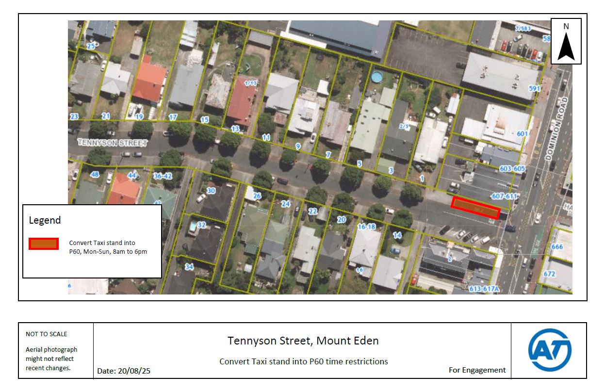
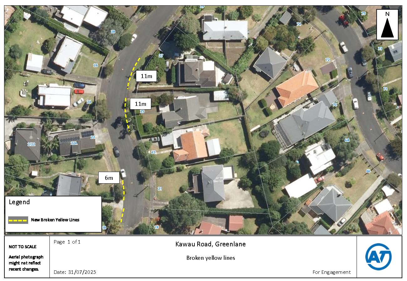
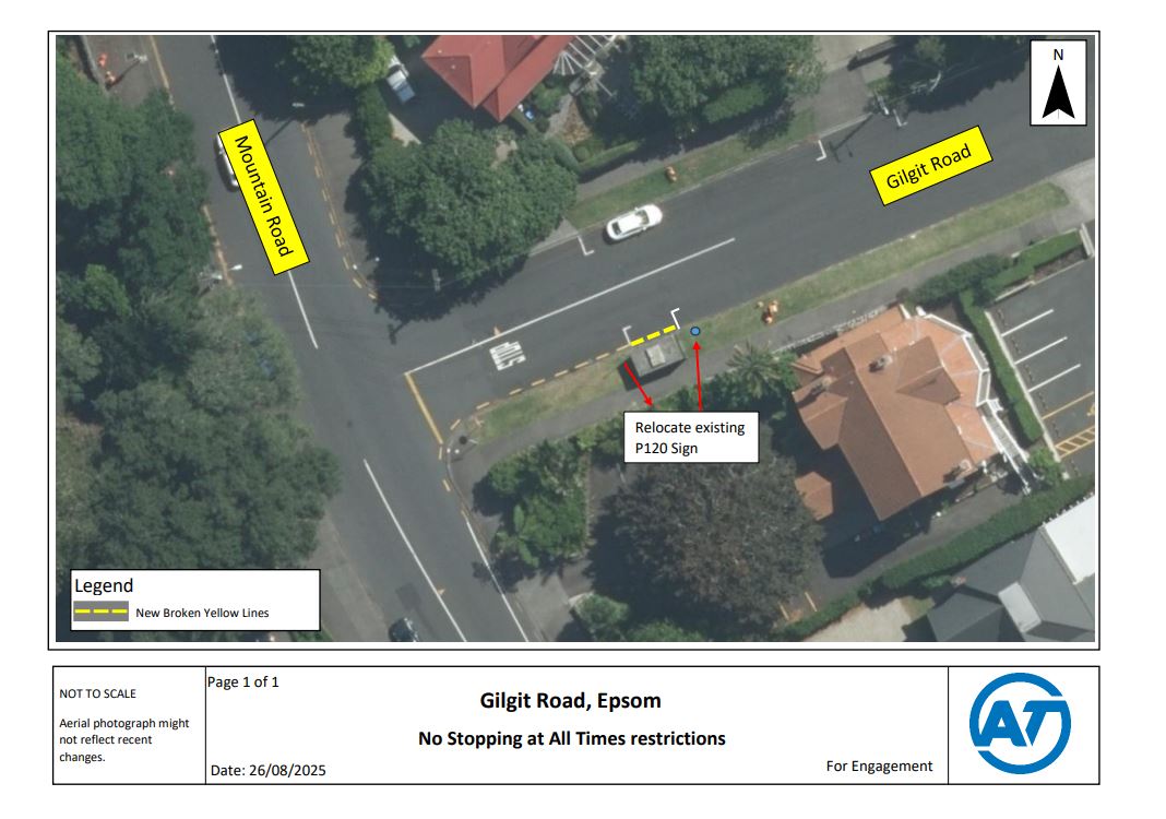
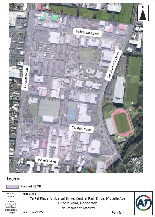
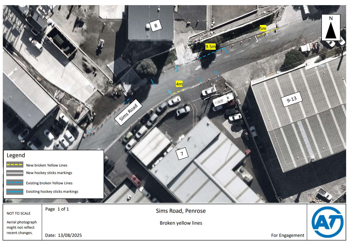
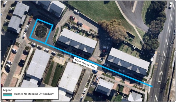
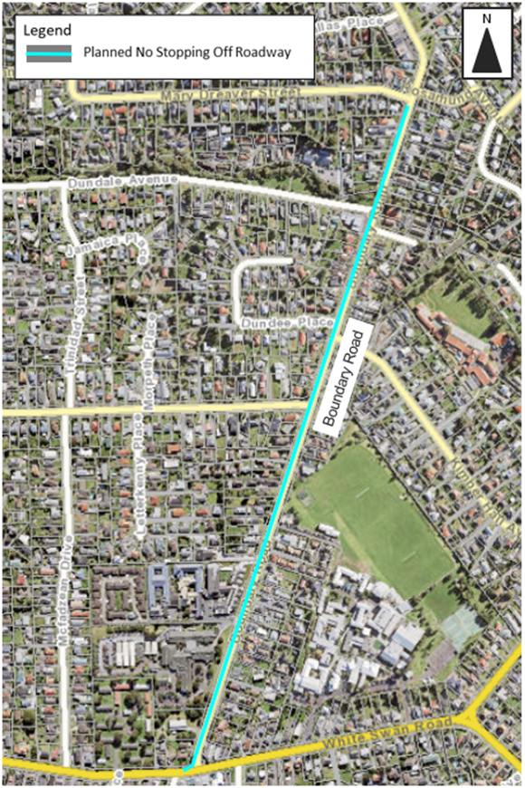
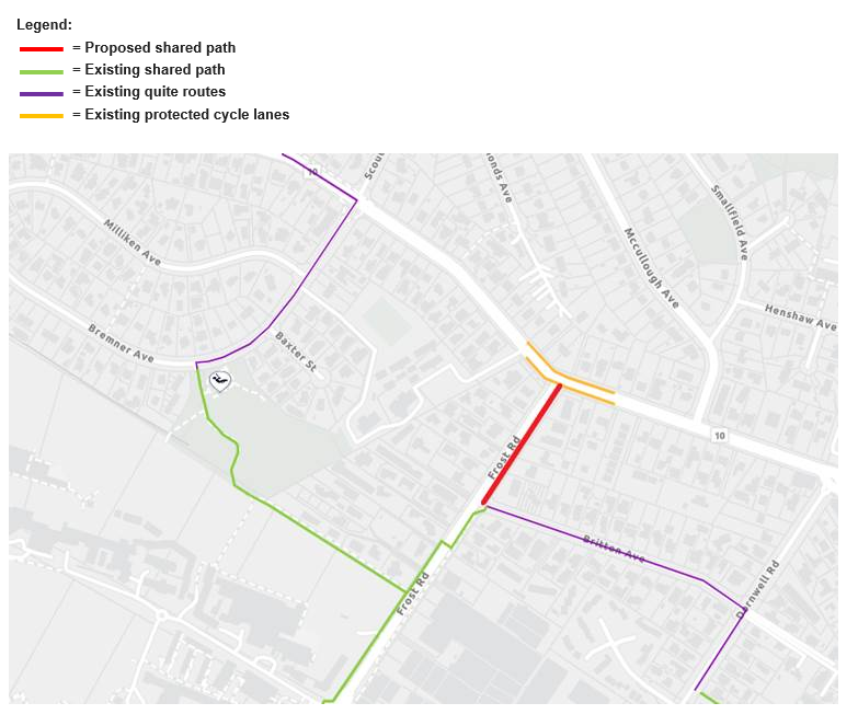
For more information