New Lynn to Avondale shared path New Lynn to Avondale shared path
Auckland Transport (AT) is partnering with the Whau Local Board, Auckland Council, and the NZ Transport Agency to build a new walking and cycling route along the rail corridor between New Lynn and Avondale.
Project status: Construction
Project area: West
Project overview
The 2.9km New Lynn to Avondale Shared Path follows the rail line from New Lynn Station through green spaces to just east of Blockhouse Bay Road.
The path will create a continuous shared path linking New Lynn Train Station, Avondale Train Station, Waterview Shared Path, the Northwestern cycleway, and city centre networks. It will also connect with the Te Whau Pathway, which follows the west side of the Whau River in Avondale, and other local walking and cycling routes.
The path will be mostly off-road and will cross the Whau River on a new purpose-built bridge (which will stand alongside the existing rail bridge). The Whau Local Board has provided significant funding for this bridge.
Features and benefits
- A safer, more appealing route for pedestrians and people on bikes.
- Easier access to local train stations and town centres.
- New landscaping and improved visual appearance of public spaces.
- New wayfinding signage.
- New cycle parking.
- Well lit and designed to promote safety for users and neighbours.
- Reduced traffic congestion and air pollution from vehicles.
View the overall concept plans (PDF 2.5MB).
Cost
The shared path will cost $44.3m. Funding for the project comes from local funding, the Whau Local Board, and the Government through the Urban Cycleways Programme.
Timeline
- April/May 2016 - consultation on the path design.
- August 2018 - complete detailed design.
- June 2019 – detailed design complete and tenders have been received.
- February 2020 - start construction of the shared path.
Shared path route
Following public consultation in 2016, we have adjusted the alignment of the path to include an underpass, bypassing the existing railway crossing.

Changes to the alignment of the shared path following consultation:
- The path will not continue along the eastern side of the railway line past Chalmers Reserve or cross the railway line and road at the Saint Georges Road crossing as originally proposed.
- Instead, an underpass will be constructed, connecting Chalmers Reserve to the western side of the railway line where the path will continue through a Housing New Zealand development and along Saint Georges Road. This change was made because of safety concerns at the Saint Georges Road railway and road crossing.
- The path will now terminate at New Lynn train station on Memorial Drive rather than crossing Clark Street and continuing to Rankin Avenue.
St Georges Road on-street cycle path and shared use path
Auckland Transport (AT) has proposed a new bi-directional cycle path in addition to the existing footpath facility on St Georges Road. These proposed changes are a part of New Lynn to Avondale shared path project.
Proposed changes:
- A 3m wide off-road bi-directional cycle path on west side of St Georges Road between Kelvinside Terrace and rail line;
- Raised pedestrian and cycle crossing at the intersection of St Georges Road and Kelvinside Terrace;
- Removal of on-street parking on St Georges Road where cycle path is proposed. A parking demand survey has been carried out which indicates that on street car park use is low (8%) and the proposed car park removal will not affect current usage along St Georges Road;
- Existing driveway ramps on St Georges Road (west side) to be reconstructed to accommodate proposed bi-directional cycle path;
- Bi-directional cycle path connects with a new 3m wide shared use path at both ends. At the north end, shared use path requires localised widening around existing trees. This end will connect with shared path running parallel to rail line through Housing New Zealand development site (not confirmed yet). At the south end, bi-directional cycle path transitions into a mono directional cycle lane before connecting with the proposed shared use path along the rail corridor.
Download the St George Street on-street cycleway and shared use path map (PDF 1.9MB)
Significance to Māori
In the past, Māori used the Whau River as a portage route between the Manukau and Waitemata Harbours.
Iwi have chosen imagery for the path and the bridge, promoting the importance to the local area of traditional waka portage and harvesting activities along the Whau River and the migration of the kuaka (godwit).
These images will be portrayed in various ways on the bridge and along the path. There will be patterns within the concrete on the bridge structure. In addition, images will be cut out of a metal panel which will run across the bridge, screening it from the adjacent rail bridge.
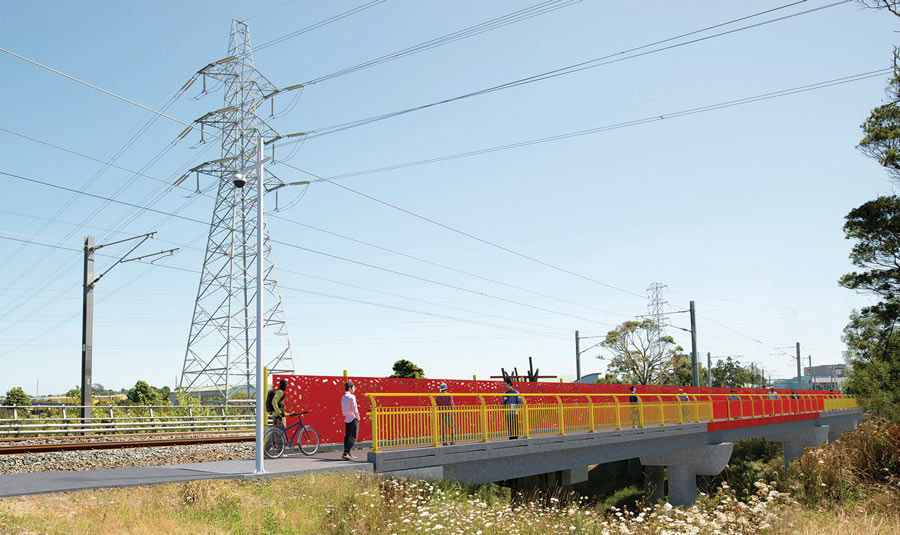
Image: Artist's impression of Whau River bridge (bridge colour indicative only).
Public engagement
Between 15 April and 15 May 2016, we invited feedback to help us improve and refine the design of the shared path.
A total of 205 people responded and many suggestions were made about the design of the path.
Since the 2016 consultation, we have responded to feedback raised. We have also adjusted the path's alignment to include an underpass, bypassing the existing railway crossing.
Feedback report
Read the public feedback and decisions report (PDF 1MB, 55 pages)
Construction update
Construction of the shared path started in November 2019. Our construction crews have navigated several challenges and delays, including:
- Working through the pandemic
- Lockdowns
- Periods of isolation
- Material supply issues.
The path will be open for the public from 1pm on Saturday 4 June, after a blessing by mana whenua and an official opening.