Carrington Road improvements
We are upgrading the essential services on Carrington Road to support local housing development and improve the access and safety of this vital route.
Project details
Start date
June 2026End date
2028Location
Carrington Road, Mount AlbertTransport involved
Walking, driving, bus, train and cyclingOverview
We are upgrading the essential services on behalf of our partners and Carrington Road to support local housing development and improving the access and safety of this vital route that connects Point Chevalier and Mount Albert town centres.
Construction begins in June 2028 to:
- upgrade existing underground services, storm water, gas and utilities
- underground the power on the western side (Unitec side) of Carrington Road
- make Carrington Road safer and more accessible
- increase its capacity
- provide people with improved travel options.
People use Carrington Road to connect with:
- buses
- trains
- SH16
- the Northwestern Cycleway
- local homes, businesses and education providers.
Over the next 10 to 15-plus years, at least 4,000 homes will be built in the area around Unitec campus. Te Kukūnga Waka (Carrington Residential Development) will increase the number of people living locally and using Carrington Road.
To accommodate this substantial growth, the existing services such as storm water, gas, fibre will need to be upgraded, in addition to improvements to the roading infrastructure. You can learn more about these different improvements in the 'Latest updates' section of this page.
We are working with our key partners and the Crown to manage the delivery of this much needed work.
Latest updates
We applied for resource consent for this project, and we requested the application be publicly notified.
This gave everyone the chance to consider the application and make a submission.
We received 7 submissions and the consent was granted on 10 February 2026.
The resource consent covers works associated with the project including:
- road widening
- earthworks
- heritage
- tree works
- construction duration
- construction noise.
Approval to commence was granted April 2026.
Contractor selection
Dempsey Wood has been selected as the main contractor for the delivery of this project. The project contract was awarded in April 2026.
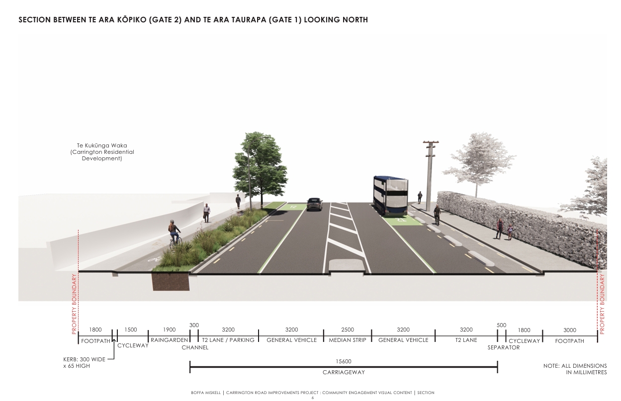
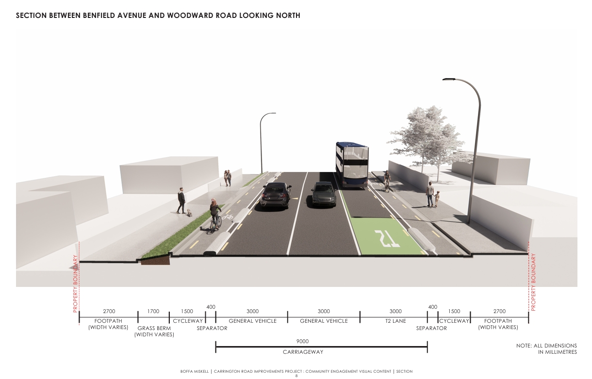
North of Woodward Road we will introduce new parking spaces, available for use outside of the T2 transit lanes’ hours of operation.
Initially the T2 lanes will operate from 7am to 10am and 3pm to 7pm in both directions, Monday to Friday. These hours are likely to be extended in future, in line with growth.
In 2026, Auckland Transport will begin a detailed assessment of parking and transportation in the area. It will consider parking demand over the next 10 years of expected growth.
The resulting Parking Management Plan will be developed in consultation with the community and will identify how we can make best use of kerbside space.
This could mean future changes to what is currently proposed for Carrington Road.
The design of the rail overbridge is currently underway. Once we have more detail, we will share what it will look like and how it will be built.
We’re investigating improvements like:
- widening the overbridge to provide more space for walking and cycling
- raising the cycleway on the western side of the overbridge to footpath level, to match the eastern side
- widening vehicle lanes while retaining the current two southbound and one northbound lane arrangement
- installing higher safety railings where the overbridge crosses the rail line
- installing queue detection technology to improve the intersection’s efficiency.
Once this work is complete and a decision is made, we’ll share with you what the upgraded overbridge will look like and how it will be built.
We’re collaborating with Watercare to incorporate a planned watermain upgrade into our project to cater for the significant housing growth that is coming to the area over the next 10 to 15 years.
By applying a “dig once” philosophy, we can deliver change more efficiently and avoid future disruption for the Carrington Road community.
We’re improving stormwater management along Carrington Road, to better cope with future rain events and a changing climate.
Raingardens will manage and treat water run-off, including from flooding. The raingardens will be a mix of low native grasses, selected ground ferns, groundcover and sedges.
A vegetated swale is planned for Segar Avenue.
A swale is a planted channel that performs a similar function to a raingarden, but rather than capturing and holding run-off, it is used to convey and filter run-off.
The Segar Avenue swale will convey stormwater run-off from Carrington Road.
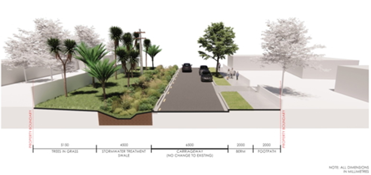
We aim to plant at least two new trees for every tree we remove.
We expect to remove 48 trees to enable the street upgrade. Of these, 34 are on Carrington Road and 14 are on Segar Avenue.
An additional nine small trees will be transplanted from their current location to another.
We will plant tree species such as tī kōuka (cabbage tree), ornamental cherry and pōhutukawa.
Project designs
Project background
The work is funded by the Government through the Infrastructure Acceleration Fund and is managed by National Infrastructure Funding and Financing (NIFF).
NIFF is the New Zealand government’s investor shopfront for private capital investments into public infrastructure.
They:
- work with the private sector, iwi and government agencies to deliver infrastructure projects involving private finance
- connect domestic and international investors with public infrastructure projects
- manage several infrastructure funds.
We’ve listened to your feedback and improved the design by:
- making sure cyclists have safe access in and out of the development and Unitec
- reviewing the entrance to Sutherland Road to ensure drivers have visibility to turn safely
- improving the design of the entrance into Prospero Terrace to make it safer for pedestrians
- closing the end of the access lane at the Woodward Road intersection so it cannot be used as a vehicle cut through
- separating pedestrians and cyclists wherever feasible
- reviewing light phasing at each intersection so that movement along and across Carrington Road is balanced
- making all raised tables a shallow gradient to improve accessibility for people walking and cycling, while enabling traffic to flow freely.
Based on all the feedback received we have made changes to the initial proposal.
From Monday 27 May 2024 to Sunday 23 June 2024, we sought feedback on the preferred option for Carrington Road.
We received 512 comments on the preferred option, focussing on a few key locations.
The Northwestern Cycleway crossing attracted 150 comments.
Sutherland Road intersection received 32 comments and Great North Road intersection received 25 comments.
Top feedback themes included
- raised tables and crossings
- safety improvements
- requests for more planting
- connections and access.
An earlier round of engagement ran from 25 August to 29 September 2023.
We received 367 responses, with strong support for:
- a one-way cycleway on both sides of the road
- bus or transit lanes in both directions, where space allows
- more pedestrian crossings
- more trees
- an upgrade that keeps Carrington Road moving.