Long-term road repairs from Auckland storms Long-term road repairs from Auckland storms
Repairing the damage to our local roads sustained during the 2023 flooding and cyclone events
During the storm events of 2023, more than 2,000 slips and roading issues were reported across the Auckland region. The flood repair programme is expected to take 3 years to complete and will cost around $390 million. We expect to complete most repairs by the end of April 2026. There will be a couple of sites still in construction at that time, but they will be well underway.
Reported sites and slip repairs
There are:
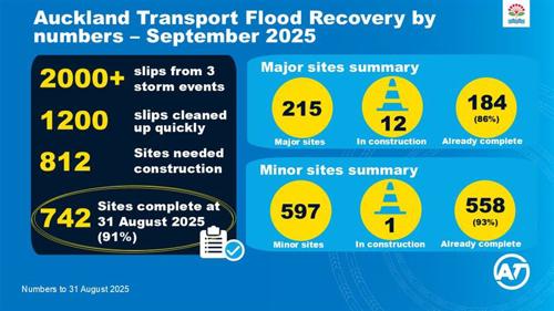
- more than 2,000 sites in total
- 1,200 small issues and slips resolved quickly
- more than 800 sites needing minor to major repairs.
Of the 812 minor and major repairs needed, we have completed 742 to 31 August 2025 (91%).
215 of the 812 sites are categorised as major (costing over $250,000). 184 of the 214 (86%) are now completed.
597 of the 812 sites are categorised as minor (under $250,000). We have now completed 558 of the 597 (93%).
This month we have 12 sites in construction.
The number of sites needing minor to major repairs changes slightly over time as the design and investigation of each site develops.
For details on this month’s progress across the regions, check out our latest report on Auckland-wide news about long-term road repairs.
You can also find information on major road repairs in your community under the following regional sections.

East & South Auckland flood recovery progress
Progress of the repair work in Karaka, Awhitu, Patumahoe, Hunua, Howick, Mellons Bay.
North Rural Auckland flood recovery progress
This page lists updates on the progress of the slip repair work in North Rural Auckland.
North Urban Auckland flood recovery progress
Progress of the repair work in Orewa, Hobsonville, North Shore, Whangaparaoa.
West Auckland flood recovery progress
Progress of the repair work Piha, Karekare, Titirangi, Laingholm, Waiatarua, Green Bay, Muriwai, Te Henga, Waitakere, and other west locations.
Electronic flood alert pilot programme
Following the extreme weather events of early 2023, Auckland Transport (AT) is testing an electronic flood alert system at 3 key sites across Auckland.
We ask for your patience, as sites across the region have sustained significant damage. Locations that have the highest risk, safety needs or are the only access route to a community are being prioritised for attention.
In some locations, we’ve been able to provide a temporary fix, such as one-lane access for residents or the wider community, until we can permanently rebuild the road.
We understand that road damage causes inconvenience to residents, due to detours and road closures. We want to reassure the community that we’ve deployed as many resources as we can, including additional contractors to work on these sites, but some roads will take time to fully repair.
If there are roading issues with a potential safety risk (for example, new slips, cracks in roads, flooding, or trees falling over roads or cycleways), call 09 355 3553 or report the problem online.
Flood recovery updates
Auckland-wide news about long-term repairs
Road repair process and slips
Contact us
- Information on unformed roads
- For bus services that have detours or are suspended due to recent storms, visit Service announcements.
- To report a new issue relating to roads, cycleways, footpaths or transport, please contact us using the online form.
- For transport alerts as they happen, sign up for travel alerts or check out our twitter feed @AT_TravelAlerts.
- For the latest information on state highway closures and disruptions, visit Waka Kotahi Journey Planner.
- To find out whether your bus stop or public transport services are affected, visit Service announcements or download the AT Mobile app.
- For information on affected Auckland Council services and facilities, including parks and walkways, visit Recovery from extreme weather and natural disasters.
- For anyone in need of emergency help, call Auckland Emergency Management on 0800 22 22 00 or, if your life is in danger, call 111.
- For Auckland Emergency Management information, including cordons coordinated by AEM, visit Piha and Muriwai.
- To report or check power outages in your area, visit Vector or Counties Energy.