Northwest transformation Northwest transformation
The Northwest Transformation is the largest urbanisation project in New Zealand. It includes the development a new town centre at Westgate, a new village centre and employment park at Hobsonville, and a residential community and marine industry precinct at Hobsonville Point.
The transformation is being delivered in stages. Auckland Transport (AT) is providing transport infrastructure to support the development.
Project status: Implementation
Project zone: North
Project overview
The Northwest Transformation is a collaboration between AT, Auckland Council, New Zealand Retail Property Group, and the Hobsonville Land Company (a subsidiary of Housing New Zealand).
AT's upgrade of the northwest transport networks aims to deliver:
- Fast, frequent, and convenient public transport options - currently focussed on bus and ferry services but this does not rule out light rail at some time in the future.
- New or upgraded roads.
- Dedicated cycle facilities.
- Quality pedestrian paths.
- New park and ride facilities at Hobsonville Point.
The upgrade has already delivered:
- A new ferry terminal at Hobsonville Point.
- A widened Fred Taylor Drive at Westgate, with cycle lanes, street planting, and reconfigured intersections that connect the existing shopping centre with the new development.
Benefits
- Encourage regional economic growth.
- Support the strategic directions of the Auckland Plan.
- High level of bus services, with bus priority measures to facilitate fast and reliable trip times.
- Improved safety and access of the roading network.
- Increased capacity at intersections for vehicle movements to and from the new motorway network.
Cost
- AT has budgeted $110M between 2012 and 2022 to provide transport infrastructure.
- In addition to AT’s budgeted works, Auckland Council is contributing a further $215M over 10 years.
Milestones
2013 – Start of new Hobsonville ferry service, road construction, and land designation process for Hobsonville Road widening.
2016 - Hobsonville Point Road completed.
2018 to 2020 (expected) - completion of Northside Drive (possibly with the addition of a motorway interchange).
2020 to 2022 (currently indicated) - Hobsonville Road upgrade construction; Brigham Creek Road widening.
Project details
Transport for future urban growth
The new Westgate and Hobsonville Point town centres are being built complete with roading and infrastructure. A ferry terminal is operational at Hobsonville Point and a new bus station is planned to be completed at Westgate in 2017. Fred Taylor Drive, which bounds the new Westgate development to the south and west, has been significantly upgraded, including installation of major watermains to future-proof water supply for predicted population growth.
The other Northwest Transformation projects are being reviewed as part of the transport for future urban growth planning study that will identify a transport network to support Auckland’s new housing and business areas.
As a result, the descriptions we provide here are indicative and provisional. The infrastructure to be built will be more or less as described but the exact scope of the projects (the transport infrastructure options and linkages with the areas they serve) will be determined as a result of the planning now being done as part of the transport for future urban growth project.
Find out more about transport for future urban growth.
Project maps
- View a map of the Northwest Transformation growth area (JPG 96KB)
- View a detailed map of the project area (PDF 3.1MB)
Key facts
- 435 hectares for development, including 167 hectares of the former Hobsonville RNZAF military airbase.
- Westgate town centre - 100 hectares and a further 56 hectares for a range of business uses.
- Development of 80 hectares adjacent to the old Hobsonville commercial area with a small village town centre.
- Community facilities including new library and parks.
- 20,000 new jobs and 5,500 new homes.
- New roads and better transport links.
- New schools.
At Westgate, Auckland Council and New Zealand Retail Property Group (NZRPG) are building a regional town centre that will be a hub for retail and commercial activity in the north-west. Together with Auckland Transport, the partners are creating new infrastructure and a civic heart, including a new town square, modern library and new connecting roads, on 156 hectares.
Regional centre
100 hectares is dedicated to a major mixed-use town centre, larger than Albany. In addition to the new library and town square, developments cater for office, education, administration, leisure, recreation, retail and residential developments. The regional centre will cater for about 5,770 jobs and 7,000 residents.
The remaining 56 hectares will be developed for a range of business uses, estimated to provide about 3,000 new jobs.
Transport and infrastructure
Auckland Transport is providing:
- A number of new roads to support the development of the new Westgate town centre, including an east-west link (Northside Drive), designed to reduce congestion on Fred Taylor Drive and Hobsonville Road.
- A new bus station in the heart of the new town centre.
Construction and upgrade of the roading network around Westgate is a joint activity between AT and the developer.
Northside Drive
Northside Drive is a new road linking Fred Taylor Drive and Trig Road. When built, Northside Drive will provide a new connection between northwest Auckland and the North Shore, catering for future growth of the northern section of the new Westgate town centre.
May 2016 - To date, the new road has been constructed from Fred Taylor Drive (formerly SH16) to the motorway (new SH16). The intention is to bridge across SH16 and extend Northside Drive to Trig Road, to connect with the North Shore via SH18. The new, to-be-built section, is referred to as Northside Drive East.
The final design of this road will be confirmed when the planning for transport for future urban growth is finalised. This may promote the possibility of a new connection between Northside Drive and SH16.
Westgate Town Square
Westgate Town Square - officially known as Te Pumanawa Square - is a large space shared by pedestrians and vehicles, where pedestrians have priority.
The 4,5002-metre square is designed as a place for people to sit, relax and spend time. It features raised and sunken lawns, an artist-designed canopy (to provide shade and shelter), a variety of trees and seating, and outdoor dining areas.
Shared zones remove the traditional distinction between footpath and road, so street furniture and other elements have been placed to slow motorists and remind them that pedestrians have right of way.
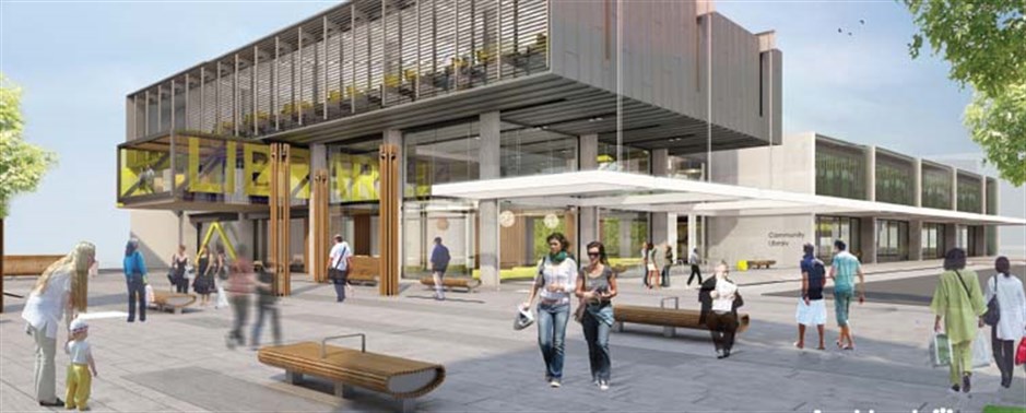
New library

A large regional three-level facility of about 3,500 square metres, the $14 million library will include a state-of-the-art children’s ‘destination’ library, community meeting rooms and spaces, a Citizens’ Advice Bureau and a café.
It will be built using environmentally-sustainable design principles and will be the first building of its type in the country designed to attain a “5 Star Green Star Certification” using the New Zealand Green Building Council’s Customs Tool Framework system. It will feature a green roof as well as a large living wall of plants.
Construction started in 2014 with the new Northwest Shopping Centre (opened in October 2015).
For more information, visit the NZRPG Westgate website.
AT will upgrade the Hobsonville Road corridor when the results of transport for future urban growth are analysed and other related planning is complete. The upgrade will be designed to support a range of new developments in the Hobsonville area between Westgate and Hobsonville Point.
These include:
- Development of 80 hectares adjacent the old Hobsonville commercial area including employment land (67 ha) with a small village town centre (13 ha).
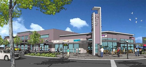
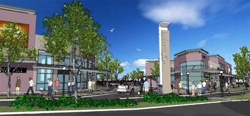
- A 13-hectare expansion of the original village centre to the western side of the road. This includes a supermarket, a number of retail shops, residential apartments, offices and other business users to support the large-scale residential development in Hobsonville Point.
These artist's impressions give an idea of what the area will look like:
Employment
The 67 hectares to be developed adjacent to the original commercial area will cater to high-intensity employment.
An employment park will be developed on Hobsonville Road, between the Brigham Creek Road and Westpark Drive intersections, with an emphasis on quality buildings and open-space environments.
Neil Developments and Brigham Creek Business Park are the 2 landowners that the council is working alongside to advance this development.
Hobsonville Road corridor upgrade
AT plans to undertake a multi-million dollar upgrade of the Hobsonville Road corridor to support these new developments.
The upgrade is designed to accommodate a quality transit network of buses, and includes upgraded intersections, wider footpaths and cycleways. Brigham Creek Road will also be widened.
Timeline
2020 to 2022: Construction on the Hobsonville Road and widening of Brigham Creek Road begins.
A total of 167 hectares of land is being redeveloped on the former Hobsonville RNZAF military airbase.
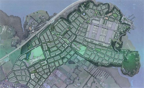
Residential
The majority of the site is proposed for 3,000 residential dwellings, along with new parks, 2 schools and a small area of shops and offices.
The redevelopment is being advanced by Hobsonville Land Company (HLC), a wholly-owned subsidiary of Housing New Zealand Corporation.
Ferry terminal and services
A ferry service operates between the new terminal at The Landing (Hobsonville Point), Beach Haven and downtown Auckland.
The service from Hobsonville Point to Downtown takes 30 minutes.